Montacuto
Montacuto | |
|---|---|
| Comune di Montacuto | |
 | |
show Location of Montacuto | |
 Montacuto Location of Montacuto in Italy | |
| Coordinates: 44°46′N 9°6′E / 44.767°N 9.100°ECoordinates: 44°46′N 9°6′E / 44.767°N 9.100°E | |
| Country | Italy |
| Region | Piedmont |
| Province | Alessandria (AL) |
| Government | |
| • Mayor | Giovanni Carlo Ferrari |
| Area | |
| • Total | 23.7 km2 (9.2 sq mi) |
| Elevation | 525 m (1,722 ft) |
| Population (31 October 2017)[3] | |
| • Total | 263 |
| • Density | 11/km2 (29/sq mi) |
| Demonym(s) | Monteacutesi |
| Time zone | UTC+1 (CET) |
| • Summer (DST) | UTC+2 (CEST) |
| Postal code | 15050 |
| Dialing code | 0131 |


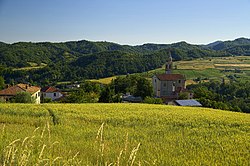
Montacuto is a comune (municipality) in the Province of Alessandria in the Italian region Piedmont, located about 120 kilometres (75 mi) southeast of Turin and about 40 kilometres (25 mi) southeast of Alessandria.
Montacuto borders the following municipalities: Albera Ligure, Cantalupo Ligure, Dernice, Fabbrica Curone, Gremiasco, and San Sebastiano Curone.
References[]
- ^ "Superficie di Comuni Province e Regioni italiane al 9 ottobre 2011". Istat. Retrieved 16 March 2019.
- ^ "Popolazione Residente al 1° Gennaio 2018". Istat. Retrieved 16 March 2019.
- ^ All demographics and other statistics: Italian statistical institute Istat.
| Authority control |
|
|---|
This article on a location in the Province of Alessandria is a stub. You can help Wikipedia by . |
Categories:
- Municipalities of the Province of Alessandria
- Cities and towns in Piedmont
- Province of Alessandria geography stubs