Mundham
| Mundham | |
|---|---|
 St. Peter's Church, Mundham | |
 Mundham Location within Norfolk | |
| Area | 6.31 km2 (2.44 sq mi) |
| Population | 177 |
| • Density | 28/km2 (73/sq mi) |
| OS grid reference | TM335978 |
| • London | 123 Miles |
| Civil parish |
|
| District | |
| Shire county | |
| Region | |
| Country | England |
| Sovereign state | United Kingdom |
| Post town | NORWICH |
| Postcode district | NR14 |
| Police | Norfolk |
| Fire | Norfolk |
| Ambulance | East of England |
| UK Parliament |
|

Mundham is a village and civil parish in the English county of Norfolk. It has a rich history, spanning back over a millennia and a half, and can trace its roots to mid Anglo Saxon England. It covers an area of 6.31 km2 (2.44 sq mi). In 2001, the population was 168 in 63 households,[1] and grew to 177 at the 2011 census.[2]
For the purposes of local government, it falls within the district of South Norfolk.
Location[]
Mundham is located 11 miles SE of Norwich. In the center of Mundham, one of the tributaries of the River Chet has its source, and in the north, Mundham borders onto the Chet itself, In the west, Mundham borders with Seething, a larger Village, while in the north east, Mundham reaches Sisland, a significantly smaller Village. In the south east the far extents of the nearby Town of Loddon reach. In the south Mundham borders Thwaite and in the south west Mundham shares a border with Hedenham and finally in the north, Mundham borders the village of Bergh Apton.
River Chet[]
The River Chet is a small river in South Norfolk, England, a tributary of the River Yare. It rises in Poringland and flows eastwards through Alpington, Bergh Apton, Thurton and Loddon. At Loddon it passes under the A146 through Loddon Mill and into Loddon Staithe. From this point onwards the river is navigable. It then passes Hardley Flood to the north, a nature reserve part-managed by the Norfolk Wildlife Trust. The river finally joins the River Yare one mile west of Reedham at Hardley Cross, erected in 1676,[3] which marks the ancient boundary between the City of Norwich and the Borough of Great Yarmouth. The total navigable length is some 3½ miles.[4] Fishing is permitted between Loddon and Hardley Cross, bream and roach being the most common catch.[5]
History and historical or notable buildings[]
Summary[]
Mundham was created pre-7th century, and St. Peters Church and the original Mundham Manor were built between then and 1086, when Mundham appears in the Doomsday book. In the 12th/13th Century, Mundham was split into Mundham Magna and Munham Parva, and St. Ethelbert's was built for use by Parva, until 1454, when Mundham re-unified, despite this St. Ethelbert's stayed open until 1749. In the 15th Century the current iteration of St. Peter's was built. Throughout the 19th century, the major landowners of Mundham was usually the owner of Mundham house, built prior to 1845, and the lord of the manor in Dickeburgh-Manclere.
Origins[]
Originally, the land of Mundham was a small farming settlement, built on the sandy soil of the river Chet, in the kingdom of East Anglia. The name originates from the pre-7th century anglo saxon name and also suffix -Munda, meaning protector, denoting either a notable resident, or dedicating it a local lord,[6] and the Saxon suffix of -ham or -hamm, means land hemmed in by water, marsh or high land; a river-meadow; a cultivated plot or the edge of woodland or moor,[7] and was created prior to the 7th century A.D., as although the first mention of Mundham and St. Peter's Church is in the original Doomsday book, the name is far older. It is listed as:
"Mundaham / Mundhala:
King's land, in the custody of Godric; also in the charge of William de Noyers; Thorold, Ulfketel and Robert de Vaux from Roger Bigot; Jocelyn from St. Edmund's; Nigel and Ansger from Robert FitzCorbucion; Isaac; Roger FitzRainard; Ralph FitzHagni. ½ church. Horse at the hall."[8]

This is also the first mention of the original Mundham house and St Peter's Church.
11th Century to 18th Century[]
St Peter's Church is easily the oldest building in Mundham, due to having Anglo Saxon foundations, and a beautiful example of a carved Norman doorway. The main body of the church dates from the 15th century, with the bell tower containing the remains of a Norman font. Some time in the 12th/13th Century, Mundham was split into Mundham Magna and Mundham Parva (Greater and Lesser Mundham respectively), roughly halfway along Thwaite Road. The split was marked by the building of a second church, St Ethelbert's, for use by Mundham Parva (despite actually being located in Mundham Magna). St Ethelbert's was not well recorded until well into the 13th century, and its rectors date from 1305 until 1454, when Mundham, as well as the two churches, were reunited, although St. Ethelbert's continued to operate until its closure in 1749, marking the start of Mundham's recorded decline, after which, lands began to be given to other villages, although Mundham was certainly a successful farming settlement prior to this. The St. Peter's church register dates from 1559, and shortly after, in 1563, the churches of Mundham and Seething were merged, forming a benefice, before being fully joined, by order of the council, in 1881. Although as of now, Mundham Parva is larger, originally it was the smaller of the pair, due to a large amount of the land of Magna being added to Seething and Sisland.
19th Century to Present[]
The 19th Century was a busy one for Mundham, the population grew, a large number of houses were built, the church was restored and had areas added to it, and a new faux-Romanesque font was added, clearly to deal with an influx of babies. In 1845, Mundham had a population of 308 people, and 69 houses,[9] although by 1854, Mundham had a population of 293 people, and 70 houses, and consisted of 2.39 sq mi (6.2 km2), which was worth £2316 (£287,980.90 in 2020), and the major landowners were G.S. Kett, who was lord of the manor in Dickeburgh-Manclere, Jonathan Farrow, esquire, the owner and builder of Mundham House, and Edward Clarke, esquire. As well as that, the priest of St. Peters was one J. T. Burt, It was described as a pleasant village, with a rectorial manor belonging with a large area of land and the advowson to the trustees of the Great Hospital, Norwich. The Mundham Poor lands are also mentioned as 3a.2r.16p., with a rent of 30 shillings per year, 20 shillings (of land?) left by Thomas Spooner in 1680, and 10s. (of land?) left by an unknown donor. The land-owning inhabitants of Mundham are listed in the directory, Jonathan Farrow of Mundham house; William Flaxman was the village blacksmith and vict.., who was situated in the Garden House; Henry King and William Smith were both shopkeepers; and Uriah Tibberman lived in Mundham Mill, as a corn miller, finally, Mr Jph. Tillet; Jno. Branch; Edward Broughton; Fred Crane; Richard Fairhead; Michael Roberts and Thos. Tillet, were all farmers.[10]
In 1879, J.T. Burt left his residency as the vicar of Mundham, and Charles Hocking Hicks took his place, a post he held for the next 39 years. By 1881, Mundham had grown to 2.42 sq mi (6.3 km2), and with a population of 295 people and 62 houses, this is the largest population in the recorded history of Mundham. The land had a collected value of £2636 (worth £327,771.01 in 2020), the majority of which was owned by , 4th Viscount Canterbury, who lived, at the time, in Dickeburgh-Manclere.[11]
By 1890, the only aspect of Mundham which had changed was the land ownership, the major owner was by then, Mr Hy. E. Garrod, however, Edward Clarke and his son, Henry, still held large estates here, as well as that, Jonathan Farrow no longer lived in Mundham House, Arthur Ernest Powell, esq, had moved in. Mundham was now officially situated in the Brooke polling district. The White's list for 1890 includes a directory of landowners, excluding all previously mentioned: The farmers were Richard Alexander, John Balls, Thos. Beverly, Alfred Button, Alfred Gilbert, Humphrey Hubert Gilbert and Mrs Ellen Tillet. George Flaxman, William Flaxman's son, was now the village blacksmith; Johnson Goff, miller and farmer; James Harrod, grocer and draper; George Warman, market gardener, fruit dealer, and vict. Garden.[12]
Prior to 1845, the second Mundham house was constructed by Jonathan Farrow, esq, built as a typical large house of the era, it possesses many interesting neoclassical features. Finally, Thwaite was added to the benefice, and then in 1983 they were combined with the parishes of Brooke and Kirstead, forming the Modern Brooke Benefice.
Mundham Magna[]
The area of Mundham Magna is now smaller but denser, although originally was the larger, northern area of Mundham until the reunification in 1454. St Peter's Church, the ruins of St Ethelbert's Church, Mundham house, and the site of the original manor, are situated within Mundham Magna.
St Peter's Church[]


These days, St. Peter's Church is an Anglican church,[13] although it was originally Catholic, as there has been a St Peter's Church on this site, in the extreme west of Mundham for over a Millenia, and it was first listed in the Doomsday book (1086) although it certainly predates by up to 400 years, although it could plausibly be older. The main church is a 15th century building, but it has Saxon foundations, and the Church is most remarkable for its Norman south doorway, which is all that remains of its Norman iteration, with three exquisitely carved members, a festival of scrolls, leaves, zigzags and rolls. The 15th century, main body of the Church is built of flint and stone, and the 15th century tower of three stages with string courses and crocheted pinnacles, as well as a battlemented parapet, turreted corners and gargoyles on each corner of the final stage with pipes to throw rainwater clear of the walls. The arcading of flint on the battlements has the remains of the lettering "SCS PERCRUS". The roof consists of red pantiles on the nave and slates on the chancel, although it was originally thatched.

Upon entering St. Peter's, it has a long and narrow nave, was constructed with using a very rare early example of Scissor beams, and one faces another, plainer, Norman doorway, once the North entrance, it now leads to a vestry. This was built in 1887, for Queen Victoria's golden jubilee, with its own fireplace, this was built at a similar time as the Northern aisle. This was added in 1863, providing a much needed at the time, 50 additional seats. As well as that, it also holds the church's small, Victorian Organ, which is the work of William Hill, one the most highly reputed Organ builders of the 19th century, and uniquely for such a small instrument, it has two full-sized keyboards and a full pedal board. On the East wall is a brass rubbing of the memorial to William Harborne, the first English Ambassador to Constantinople. There are two Tudor South windows in the Nave, and on the outside of the church they have carved heads on the window frame.

The beautifully carved wooden Rood Screen, used to separate the people's church from the Chancel, with carved childrens heads, which was once painted, and the Poppy heads on the ends of the Pews are both 15th century carving, the last three of which on the north side are inscribed with the word 'singers'; and on the right of the Rood screen is where the pulpit (removed in 1962 for safety reasons) was. There is a hourglass holder on the south side of the screen, this was used to time the priests' sermons, and nearby a recess shows the way up to where the Rood loft once was. The 15th century wall plate was once red and white, but has since lost its colour. The Church font, in the Bell tower, is a recent Victorian addition of 1877, but the remains of the original Norman, 13th century, Purbeck Marble font is kept in the corner of the tower, and it is also depicted in a Cotman engraving near the door, as the original font was lost for many years until it was eventually found in a pond in the Otleys (now called Rysa Lodge), likely due to it being used as a feeding trough. As well as the fonts, a Tudor fireplace/wafer oven, one of half a dozen left in Norfolk, and Consecration cross in a southern tower recess was discovered in the 1930's, and opposite are recesses for banners.[14]


The walls of the 15th century main building are painted with saints and other such more Catholic imagery, unfortunately these were painted over at some point, possibly during England's conversion to Protestantism, and all that has been recovered is on North wall of the nave are the remains of the wall painting depicting St. Christopher, although a large part is covered by a memorial to one Robert Grimer, placed long after the fact in 1797, however, the floral border still survives, as well as a scroll, whose inscription is likely an invitation to say a prayer before the image. The Reredos and communion table were carved in September 1908 by Mrs Hicks, wife of Charles Hocking Hicks, and dedicated by one Dean LeFroy. There are three bells in the bell chamber; one of the smallest is the Sanctus bell, a very rare "narrow waisted" design, which was removed from St. Ethelbert's church in Mundham Parva when it was dissolved in 1749, and fell into decay. The other two bells are both Angelus bells, but in Mundham they are known as 'the Gabriel bells'. As well as that, the church contains a rare example of the Royal Arms for George II, dated 1743, and just inside the door on the right is the Holy Water Stoup. The Chancel contains three simple windows, and these have the names of the glaziers scratched on the glass, and the only stained glass in the church is the cartouche of St. Peter's Keys in the east window, behind the Reredos, added in 1953 for the coronation of Queen Elizabeth II. The East end of the church, the Chancel, is raised to honour the altar, this, however, makes the 15th century Piscina (which is contained in a canopied recess) and Sedilia relatively low. As well as that, the credence shelf is mediaeval, and it is very rare, due to the fact that it has notches that hold the chalice upside-down while it drains. Some of the newest additions to the church are; in 1911, in the form of brick steps; and in 1968, the ancient building was finally installed with electric lighting and heating.
Location[]
Loddon Rd, Norwich NR14 6EH Coordinates: 52.530433, 1.426363
Memorials and Notable People[]
As is typical of such an ancient church, St. Peters Church contains many internal burials and memorials of those who have contributed to the church, the village, and the country as a whole.
Henry Arborn[]
The oldest memorial in the building, this metal floor plaque dates from 1538, and is situated at the head of the Chancel. It is written in a medieval cursive style, and is very difficult to read. The entire plaque is transcribed below.
"Of your charitie pray for the soule of Henry Arborn whois bodie lieth buried under this ston @ died in the XXIX yeir of our sovreign lord kyng Henry the VIII on whose soule Jesu have mercy amen."[15]
The symbols shown above represent the symbols on the inscription. This is one of the last examples of the use of prayer clauses in a memorial inscription in Norfolk, for shortly after this prayers for the dead were outlawed. However, this owner of this plaque, Henry Arborn, is related to another resident of Mundham, William Harborne, for having gained a H and E in 80 years was not so unusual at the time, and as Henry was dead by the time William was born, Henry Arborn must be William Harborne's Grandfather.[16]
William Harborne[]
William Harborne is one of the most notable and historically significant residents of Mundham. He acted as the first English ambassador to Constantinople for Elizabeth I until August 1588, leaving it as one of the most powerful positions in the English foreign service, when he retired to, and later died in Mundham, due to the fact that his grandfather, Henry Arborn, had lived and died here. He rests underneath his floor plaque to this day. The plaque reads:
"Behold a dead mans howse who full of dayes, retirde here from the world desert and praise should sitt uppon in vertuous strife, this to instruct and that to wright his life. Heires spare your cost, he needs no tombe in death, who Embassagde for Queene Elizabeth, his next will be when at the generall dome God sends his soule to fetch his bodye home"
Harborne played a key role in preventing the Ottoman Empire from supporting Catholic Spain in the war with Protestant England that was taking place at the time. Harborne was able to persuade the Porte that Spain was a threat to peace for all of Europe. Although he was unable to obtain a military alliance with the Ottomans, the Spanish-Ottoman protocol was not renewed in 1587. The Elizabethan Treaty was renewed and would survive for 343 years with England and Turkey. The Turkish powers were furious; and the Englishman was threatened several times by the French to be turfed out.
The Randall family[]


The next memorial chronologically, Elizabeth Randall was the Granddaughter of William Harborne, esquire, and Elizabeth Harborne (née Drury), the daughter of Gregory Randall and Elizabeth Randall (née Harborne). She was born in 1629 and died in January 1652 at the age of 23. Her memorial reads:
"Elizabethae filia unica Gregorij Randall Generosi & Elizabethae uxoris ejus unius filiarum gulielmi Harborne armigeri hic sepultae fuit hense Jan anno 1652, aetatis suae 23"
"Elizabeth, the only daughter of Gregory Randall, noble and Elizabeth, his wife, one of the daughters of William Harborne, esquire, was buried here Jan. 1652, at the age of 23"
After her death, the brother or son of Gregory Randall, William Randall lost four daughters at birth in August of 1671. Their memorial reads:
"Quatuor infantes filiolae gulielmi randall generosi & Elizabethae uxoris ejus unius filiarum gulielmi cookrade brooke barronetti sunt hic sepultae, in quarum memoriam hunc lapidem posvit earum pater hense augusti 1671"
"Four infant daughters of William Randall, noble, and Elizabeth his wife, one of the daughters of William Cooke, barronet of brooke, are buried here, in memory of which their father laid this stone in August 1671"
If he is Gregory's son, he would have been 17 or younger, his wife was another Elizabeth Randall (née Cooke), whose father was William Cooke, first Baronet of Broome hall. William Cooke had a son, William, who became the second and final Baronet of Broome hall.
For this family tree, maiden names will be used.
| Harborne/Randall Family Tree | |||||||||||||||||||||||||||||||||||||||||||||||||||||||||||||||||||||||||||||||||||||||||||||||||||||||||||||||||||||||||||||||||||||||||||||||||||||||||||||||||||||||||||||||||||||||||||||||||||||||||||||||||||||||||||||||||||||||||||||||||||||||||||||||||||||||||||||||||||||||||||||||||||||||||||||||||||||||||||||||||||||||||||||||||||||||||||||||||||||||||||||||||||||||||||||||||||||||||||
|---|---|---|---|---|---|---|---|---|---|---|---|---|---|---|---|---|---|---|---|---|---|---|---|---|---|---|---|---|---|---|---|---|---|---|---|---|---|---|---|---|---|---|---|---|---|---|---|---|---|---|---|---|---|---|---|---|---|---|---|---|---|---|---|---|---|---|---|---|---|---|---|---|---|---|---|---|---|---|---|---|---|---|---|---|---|---|---|---|---|---|---|---|---|---|---|---|---|---|---|---|---|---|---|---|---|---|---|---|---|---|---|---|---|---|---|---|---|---|---|---|---|---|---|---|---|---|---|---|---|---|---|---|---|---|---|---|---|---|---|---|---|---|---|---|---|---|---|---|---|---|---|---|---|---|---|---|---|---|---|---|---|---|---|---|---|---|---|---|---|---|---|---|---|---|---|---|---|---|---|---|---|---|---|---|---|---|---|---|---|---|---|---|---|---|---|---|---|---|---|---|---|---|---|---|---|---|---|---|---|---|---|---|---|---|---|---|---|---|---|---|---|---|---|---|---|---|---|---|---|---|---|---|---|---|---|---|---|---|---|---|---|---|---|---|---|---|---|---|---|---|---|---|---|---|---|---|---|---|---|---|---|---|---|---|---|---|---|---|---|---|---|---|---|---|---|---|---|---|---|---|---|---|---|---|---|---|---|---|---|---|---|---|---|---|---|---|---|---|---|---|---|---|---|---|---|---|---|---|---|---|---|---|---|---|---|---|---|---|---|---|---|---|---|---|---|---|---|---|---|---|---|---|---|---|---|---|---|---|---|---|---|---|---|---|---|---|---|---|---|---|---|---|---|---|---|---|---|---|---|---|---|---|---|---|---|---|---|---|---|---|---|---|---|---|---|---|---|---|---|---|---|---|---|---|---|---|---|---|---|---|---|---|---|---|---|
| |||||||||||||||||||||||||||||||||||||||||||||||||||||||||||||||||||||||||||||||||||||||||||||||||||||||||||||||||||||||||||||||||||||||||||||||||||||||||||||||||||||||||||||||||||||||||||||||||||||||||||||||||||||||||||||||||||||||||||||||||||||||||||||||||||||||||||||||||||||||||||||||||||||||||||||||||||||||||||||||||||||||||||||||||||||||||||||||||||||||||||||||||||||||||||||||||||||||||||
The Grimer family[]


The Grimers were, in their time, one of the major land owners of Mundham. The first record of one of the Grimers living in Mundham, is that of Robert Greymer born in 1523, his son, William Grymer, born 1545, had 3 children, Ann, Prudence and Robert. Robert Grymer has only the date 1598 associated with him, and a son William Grymer. William later married one Elizabeth Thrower, having two children, Ann, born 1601, and Robert, born 1608, before Elizabeth died in 1621 and he died in 1634. Robert Grimer married Ann Neale on 11/05/1634, and had seven children together, Robert 1637 – 1680, Ann born 1639, Elizabeth 1642 – 1702, William and John born 1644, Thomas born 1647 and Edward born 1652. Their son William Grimer 1644 – 1702 is listed as “of Mundham, Yeoman”. He married an Elizabeth Reeve in Mundham in 1671 and had two children, John born 1677, who died on February 27th 1750, at the age of 73, and Robert born 1690, Elizabeth died in 1735.

William's son Robert Grimer, 1690 – 1759 is recorded as “of Mundham, Gent”. He married Hannah Wrench in 1721 and they had two daughters, Hannah born in 1723 and Elizabeth born in 1734. Their mother Hannah died in 1725 and Robert then married a Mary Clarke by whom they had a son Robert 1740 – 1795.
There are floor inscriptions present in St Peters Church, honouring both wives, Hannah and Mary, his daughter Hannah and his brother John. The inscriptions also show a 'self assigned' coat of arms with three golden eagles on a green shield.
The entry for Robert 1740 – 1795 is listed as “of Mundham, Gent”. He married Hannah Mickelburgh, in 1767 at St Margaret and St Remigius Church, Seething. Their children are listed as Mary born 1767, Robert born 1772, Hannah born 1769 and Elizabeth born 1771. Their father Robert and mother Hannah have a wall mounted memorial in St Peters Church.
For ease of reading, in this family tree, names which appear multiple times will be numbered.
| Grimer Family Tree | |||||||||||||||||||||||||||||||||||||||||||||||||||||||||||||||||||||||||||||||||||||||||||||||||||||||||||||||||||||||||||||||||||||||||||||||||||||||||||||||||||||||||||||||||||||||||||||||||||||||||||||||||||||||||||||||||||||||||||||||||||||||||||||||||||||||||||||||||||||||||||||||||||||||||||||||||||||||||||||||||||||||||||||||||||||||||||||||||||||||||||||||||||||||||||||||||||||||||||||||||||||||||||||||||||||||||||||||||||||||||||||||||||||||||||||||||||||||||||||||||||||||||||||||||||||||||||||||||||||||||||||||||||||||||||||||||||||||||||||||||||||||||||||||||||||||||||||||||||||||||||||||||||||||||||||||||||||||||||||||||||||||||||||||||||||||||||||||||||||||||||||||||||||||||||||||||||||||||||||||||||||||||||||||||||||||||||||||||||||||||||||||||||||||||||||||||||||||||||||||||||||||||||||||||||||||||||||||||||||||||||||||||||||||||||||||||||||||||||||||||||||||||||||||||||||||||||||||||||||||||||||||||||||||||||||||||||||||||||||||||||||||||||||||||||||||||||||||||||||||
|---|---|---|---|---|---|---|---|---|---|---|---|---|---|---|---|---|---|---|---|---|---|---|---|---|---|---|---|---|---|---|---|---|---|---|---|---|---|---|---|---|---|---|---|---|---|---|---|---|---|---|---|---|---|---|---|---|---|---|---|---|---|---|---|---|---|---|---|---|---|---|---|---|---|---|---|---|---|---|---|---|---|---|---|---|---|---|---|---|---|---|---|---|---|---|---|---|---|---|---|---|---|---|---|---|---|---|---|---|---|---|---|---|---|---|---|---|---|---|---|---|---|---|---|---|---|---|---|---|---|---|---|---|---|---|---|---|---|---|---|---|---|---|---|---|---|---|---|---|---|---|---|---|---|---|---|---|---|---|---|---|---|---|---|---|---|---|---|---|---|---|---|---|---|---|---|---|---|---|---|---|---|---|---|---|---|---|---|---|---|---|---|---|---|---|---|---|---|---|---|---|---|---|---|---|---|---|---|---|---|---|---|---|---|---|---|---|---|---|---|---|---|---|---|---|---|---|---|---|---|---|---|---|---|---|---|---|---|---|---|---|---|---|---|---|---|---|---|---|---|---|---|---|---|---|---|---|---|---|---|---|---|---|---|---|---|---|---|---|---|---|---|---|---|---|---|---|---|---|---|---|---|---|---|---|---|---|---|---|---|---|---|---|---|---|---|---|---|---|---|---|---|---|---|---|---|---|---|---|---|---|---|---|---|---|---|---|---|---|---|---|---|---|---|---|---|---|---|---|---|---|---|---|---|---|---|---|---|---|---|---|---|---|---|---|---|---|---|---|---|---|---|---|---|---|---|---|---|---|---|---|---|---|---|---|---|---|---|---|---|---|---|---|---|---|---|---|---|---|---|---|---|---|---|---|---|---|---|---|---|---|---|---|---|---|---|---|---|---|---|---|---|---|---|---|---|---|---|---|---|---|---|---|---|---|---|---|---|---|---|---|---|---|---|---|---|---|---|---|---|---|---|---|---|---|---|---|---|---|---|---|---|---|---|---|---|---|---|---|---|---|---|---|---|---|---|---|---|---|---|---|---|---|---|---|---|---|---|---|---|---|---|---|---|---|---|---|---|---|---|---|---|---|---|---|---|---|---|---|---|---|---|---|---|---|---|---|---|---|---|---|---|---|---|---|---|---|---|---|---|---|---|---|---|---|---|---|---|---|---|---|---|---|---|---|---|---|---|---|---|---|---|---|---|---|---|---|---|---|---|---|---|---|---|---|---|---|---|---|---|---|---|---|---|---|---|---|---|---|---|---|---|---|---|---|---|---|---|---|---|---|---|---|---|---|---|---|---|---|---|---|---|---|---|---|---|---|---|---|---|---|---|---|---|---|---|---|---|---|---|---|---|---|---|---|---|---|---|---|---|---|---|---|---|---|---|---|---|---|---|---|---|---|---|---|---|---|---|---|---|---|---|---|---|---|---|---|---|---|---|---|---|---|---|---|---|---|---|---|---|---|---|---|---|---|---|---|---|---|---|---|---|---|---|---|---|---|---|---|---|---|---|---|---|---|---|---|---|---|---|---|---|---|---|---|---|---|---|---|---|---|---|---|---|---|---|---|---|---|---|---|---|---|---|---|---|---|---|---|---|---|---|---|---|---|---|---|---|---|---|---|---|---|---|---|---|---|---|---|---|---|---|---|---|---|---|---|---|---|---|---|---|---|---|---|---|---|---|---|---|---|---|---|---|---|---|---|---|---|---|---|---|---|---|---|---|---|---|---|---|---|---|---|---|---|---|---|---|---|---|---|---|---|---|---|---|---|---|---|---|---|---|---|---|---|---|---|---|---|---|---|---|---|---|---|---|---|---|---|---|---|---|---|---|---|---|---|---|---|---|---|---|---|---|---|---|---|---|---|---|---|---|---|---|---|---|---|---|---|---|---|---|---|---|---|---|---|---|---|---|---|---|---|---|---|---|---|---|---|---|---|---|---|---|---|---|---|---|---|---|---|---|---|---|---|---|---|---|---|---|---|---|---|---|---|---|---|---|---|---|---|---|---|---|---|---|---|---|---|---|---|---|---|---|---|---|---|---|---|---|---|---|---|---|---|---|---|---|---|---|---|---|---|---|---|---|---|---|---|---|---|---|---|---|---|---|---|---|---|---|---|---|---|---|---|---|---|---|---|---|---|---|---|---|---|---|---|---|---|---|---|---|---|---|---|---|---|---|---|---|---|---|---|---|---|---|---|---|---|---|---|---|---|---|---|---|---|---|---|---|---|---|---|---|---|---|---|---|---|---|
| |||||||||||||||||||||||||||||||||||||||||||||||||||||||||||||||||||||||||||||||||||||||||||||||||||||||||||||||||||||||||||||||||||||||||||||||||||||||||||||||||||||||||||||||||||||||||||||||||||||||||||||||||||||||||||||||||||||||||||||||||||||||||||||||||||||||||||||||||||||||||||||||||||||||||||||||||||||||||||||||||||||||||||||||||||||||||||||||||||||||||||||||||||||||||||||||||||||||||||||||||||||||||||||||||||||||||||||||||||||||||||||||||||||||||||||||||||||||||||||||||||||||||||||||||||||||||||||||||||||||||||||||||||||||||||||||||||||||||||||||||||||||||||||||||||||||||||||||||||||||||||||||||||||||||||||||||||||||||||||||||||||||||||||||||||||||||||||||||||||||||||||||||||||||||||||||||||||||||||||||||||||||||||||||||||||||||||||||||||||||||||||||||||||||||||||||||||||||||||||||||||||||||||||||||||||||||||||||||||||||||||||||||||||||||||||||||||||||||||||||||||||||||||||||||||||||||||||||||||||||||||||||||||||||||||||||||||||||||||||||||||||||||||||||||||||||||||||||||||||||
The War Memorial[]

In St. Peter's Church, on the south wall of the aisle, is the World War One war memorial, carved into Italian marble, it is a fitting memory to those who lost their lives fighting for their country.
The list of the dead goes as follows:
- Alfred William Adams - Private, 7th Norfolks
- Harry Chilvers - Private, 2nd Norfolks
- Albert William Copeman - Private, 9th Norfolks
- Robert Copeman - Lance Corporal, 8th Norfolks
- Edward James Doubleday - Private, 3rd Norfolks
- James Ewles - Private, 1st Suffolks
- Herbert George Fenn - Sergeant, Machine Gun Corps
- Herbert Nichols - Private, 1st Essex
- Harold Thurtle - Private, 1st Essex
"Their Name Liveth for Evermore"
Charles Hocking Hicks[]

Rev. Charles Hicks was vicar of Mundham and Seething from 1879 to 1918, and was named "Honorary Chaplain to the Royal National Mission to the Deep Sea Fishermen". He died on November 18th 1930. During his long stay as vicar, Rev. Hicks oversaw the church undergo many changes, such as the addition of brick steps in 1911 and the new Reredos and Communion table in 1908, carved by his wife.
George Eardley Todd[]

George Todd was the churchwarden of St. Peter's Church from 1923 to 1939, before he left for military service in World War Two, never to return to the position, presumably due to his death. He held the rank of Lieutenant Colonel in the British Army, making him both the only known officer and the highest ranked military personnel to ever reside in Mundham.
St Ethelbert's Church[]

St. Ethelbert's Church was an Anglican church,[17] which was built for the purpose of being used by the newly created Mundham Parva during the split of Mundham in the 12/13th century, and although Mundham reunified in 1454, St. Ethelbert's was not made redundant until 1749, almost 300 years later. St Ethelbert's was not well recorded until well into the 13th century, and its rectors date from 1305 until 1454, when it closed. It is found near the centre of Mundham, the ruins of St Ethelbert's are hidden by a little wooded copse, and due to this, in summer, it is virtually impossible to find the ruin. If searching, you will find the ground falls suddenly away, forming the edge of the former graveyard, then there are three pillars of flint and stone topped by shaggy outcrops of elder, Two form the east wall either side of a window, while the third formed part of the north wall. There are surviving blocks of stone in the former east window outline, and a putlog hole to the right of it. For a building of which virtually nothing now survives, St Ethelbert has a relatively recent redundancy date, the fast decimation of the chapel is mostly credited to looting, this is seen, as many local buildings possess stone and window frames very typical of a chapel of that era. Well into the 19th century it was possible for antiquarians to date it as a 13th century building.[18]
Location[]
Loddon Rd, Norwich NR14 6EJ Coordinates: 52.527897, 1.436276
Mundham House[]

Mundham House is a grade II listed, late 18th century brick house with neoclassical features, and it was built by Jonathan Farrow, of which the first mention is on the Faden's map from 1797. The house was extended and altered in the 19th and 20th centuries. The house has sash windows, with gauged and rubbed brick arches; a central pedimented door; a peacock tail fanlight and an elaborately tiled exterior lavatory dating to c.1880. The stables also date to the 18th or early 19th century and has lunette windows.[19] It also appeared in White's 1854 - 1890, under the ownership of Jonathan Farrow, esq, and then one Arthur Ernest Powell, esq.
Location[]
Thwaite Rd, Norwich NR14 6FD Coordinates: 52.526019, 1.440007
The Original Mundham Manor[]
South east of St. Peter's Church is the site of the original, pre 12th century, Mundham Manor house, originally built both before the split into Magna and Parva in the 13th century, and the reunification in 1454. It was constructed by some of the oldest landowners, although nothing now remains of the main building, the most recent form of the stables were converted into a private residence, and the house's foundations have been discovered in the garden. The last iteration of the house burned down, and was demolished soon after, and although it is thought to appear upon a map from 1797, this has not been verified. The house originates between 1200 and mid Anglo-saxon England.
Mundham Mill[]

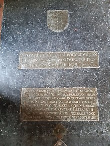
At the top of Mundham Common, there is a building, now a private residence which, up to the 1940's/50's was a sweet shop, and was one of the few businesses situated in Mundham during the 20th century, and behind which is the site of the old Mundham mill, to which it lends the house its name. Like many sites in Mundham, the mill first verifiably appears in the 1797 Faden's map of Mundham, although one is thought to have been on the site since Medieval times. In 1819, the mill was under the ownership of one Mr. William Brown of Sizeland, when, on the 30th July, two children, Amelia and Robert Pitcher, aged 3½ and 4¾ respectively, were killed when hit with the mill sails, and two days later, on August 1st, they were buried in St. Peters Churchyard. The press story reads:
"At Mundham mill, belonging to Mr. W. Brown of Sizeland, two children one aged three, other five playing in yard when sails knocked down girl. Boy ran to her assistance also struck by sails and killed. Girl died soon afterwards.
Essex Herald - 10th August 1819"
The mill reappears in 1826 in the Bryants map, and in 1834 in the Greenwoods map. From 1845 to 1852, the Mill was owned by one William Beverly, and in the 1851 census, his family is: William Beverly, age 51 (employing 1 man) Mary Ann Beverly (42) Mary Ann Beverly (16) William Beverly (13) scholar Michael Beverly (11) scholar Emma Beverly (8) scholar Margrett Beverly (3) scholar
Unfortunately, by 1852, William Beverly was declared insolvent, having owned the mill for seven years, and the mill came under the ownership of a G.S Kett. In April, Beverly's estate was assigned to trust for the benefit of creditors, and in June the mill was auctioned off. By 1854 the mill had come under the ownership of one Uriah Tibbenham, who ran the mill from 1864 to 1872, a span of eight years. The next recorded mention of the Mill is in 1875, under the tenancy of Johnson Goff, but by May 1880, the mill was advertised to be let, although in 1883 he was still the tenant miller there. At the same time, the previously wind powered mill was changed to a wind and steam method. Johnson continued to run the mill, until 20th July 1901, when the mill was put up for auction and bought by him, finally bringing the mill under his ownership, which he continued to run and own until 1908, having done so for the span of 33 years. In 1908, mill was bought by Ezra Upton, who ran the mill, adding an oil engine in 1916, until its demolition in 1936/7, and by 1937 only the broken wall of the roundhouse remained.[20] Behind the modern house and the windmill site is the site of the old miller's house. During or after the second world war, a Mrs Batchlor moved in, and angry at the council for removing many old trees, she planted one of her own in the 1950/60s, whose imposing bulk looks over the road to this day. She died in 1970.
Mundham Parva[]
The area of Mundham Parva is now larger but sparser, although originally was the smaller, southern area of Mundham until the reunification in 1454. Of historical significance, it only contains a large farmhouse, the majority of Seething airfield and the entirety of Seething observatory.
Seething Airfield[]

Contrary to its name, none of Seething Airfield is located inside Seething anymore, the name is due to the fact that originally the airfield extended further south and west, and its close proximity to the Mundham-Seething border, and Seething's moderately (at the time) larger population, and less sparse nature.
Constructed in 1942, for use as an American airbase for the Second World War, the Airfield was originally known as RAF Seething, and found itself host to the 448th Bomb Group, a part of the 2nd Air Division of the 8th American Air Force, and constructed as a base for Liberator bombers. [21]
Other Buildings of Interest[]
Listed Buildings[]
Within Mundham, there are thirteen listed buildings, twelve Grade II listed sites, and one Grade I, that being St. Peter's Church.[22]
Mundham Magna
- St. Peter's Church: Grade I
- Abbey Farmhouse: Grade II
- Elfreder Cottage: Grade II
- Hall Farmhouse: Grade II
- Barn at Hall farm: Grade II
- Barn at Elfreder Cottage: Grade II
- White house Farmhouse: Grade II
- Lower Barn: Grade II
- Mundham House: Grade II
- Stables of Mundham House: Grade II
- Ruins of St Ethelberts: Grade II
Mundham Parva
- The Laurels: Grade II
- Mundham Grange: Grade II
The Garden House[]
Another business situated in Mundham was the public house called "The Garden House", the first recorded mention of which is on a map from 1797, and again in 1854, when it was the site of a blacksmithery owned by William Flaxman, but for most of the 20th century it acted as the local pub until its closure in the 1990s.
The Old School[]
One of the other interesting sites in Mundham, is that of an old school girls finishing school, located on Mundham lane.
The Three Chapels[]
In the mid 19th Century, two chapels were founded on the same site, one Primitive Methodist in 1833,[23] and one Baptist in 1849,[24] whether or not these chapels overlap in their occupancy is unknown. In the late 19th Century, the third chapel was founded, it was a Wesleyan Methodist church, and was founded in 1893, and became Methodist in 1932 due to the Methodist unification, before closing in 1980, after 87 years.[25]
Demography 1801 to 2011[]
| Year | Houses | Families | Population | Males | Females | Area (Acres) |
|---|---|---|---|---|---|---|
| 1801 | 46 | 51 | 242 | 119 | 123 | |
| 1811 | 46 | 56 | 265 | 130 | 135 | |
| 1821 | 44 | 65 | 304 | 161 | 143 | |
| 1831 | 48 | 64 | 314 | 164 | 150 | 1500 |
| 1841 | 70 | -- | 308 | 162 | 146 | ---- |
| 1851 | 70 | -- | 293 | 155 | 138 | 1547 |
| 1861 | 61 | -- | 282 | --- | --- | ---- |
| 1871 | 63 | 67 | 269 | --- | --- | ---- |
| 1881 | 66 | 63 | 295 | 152 | 143 | 1547 |
| 1891 | 64 | 59 | 282 | 158 | 124 | 1562 |
| 1901 | 62 | 52 | 233 | 126 | 107 | 1562[26] |
| 1911 | -- | 59 | 234 | 131 | 103 | |
| 1921 | 59 | 61 | 234 | 123 | 108 | |
| 1931 | 62 | 62 | 218 | 108 | 110 | |
| 1941 | -- | -- | --- | |||
| 1951 | 53 | 53 | 183 | 101 | 82 | |
| 1961 | 54[27] | 54[28] | 164[29] | 82 | 82[30] | |
| 1971 | -- | -- | --- | |||
| 1981 | -- | -- | --- | |||
| 1991 | -- | -- | --- | |||
| 2001 | 63 | 63 | 168 | |||
| 2011 | -- | -- | 177 | |||
| 2021 | 64 | 64 | --- |
References[]
- ^ "Mundham parish information". South Norfolk Council. 4 January 2006. Archived from the original on 10 October 2008. Retrieved 20 June 2009.
- ^ "Parish population 2011". Retrieved 5 September 2015.
- ^ Norwich Boundary Crosses Archived 13 October 2006 at the Wayback Machine
- ^ "River Chet". Loddon.org.uk. Archived from the original on 27 September 2007. Retrieved 10 February 2019.
- ^ "River Chet Waterscape Information". Wayback Machine. 27 September 2007. Archived from the original on 27 September 2007. Retrieved 30 November 2020.
- ^ "Surname Database: Manford Last Name Origin".
- ^ "Key to English Place-names".
- ^ "The Domesday Book Online - Norfolk M-R".
- ^ "Genuki: Norfolk: Mundham, Norfolk".
- ^ History, Gazetteer & Directory of Norfolk. Sheffield: William White. 1854.
 This article incorporates text from this source, which is in the public domain.
- ^ History, Gazetteer & Directory of Norfolk. Sheffield: William White. 1883. This article incorporates text from this source, which is in the public domain.
- ^ History, Gazetteer & Directory of Norfolk. Sheffield: William White. 1890. This article incorporates text from this source, which is in the public domain.
- ^ "Genuki: Mundham, Norfolk".
- ^ "Norfolk Churches".
- ^ "Norfolk Churches".
- ^ "Norfolk Churches".
- ^ "Genuki: Mundham, Norfolk".
- ^ "Mundham St Ethelbert".
- ^ "Mundham House, Mundham, Norfolk".
- ^ "Norfolk Mills - Mundham postmill".
- ^ https://www.seething-airfield.co.uk/history.html
- ^ https://britishlistedbuildings.co.uk/england/mundham-south-norfolk-norfolk#.YbMnFSiTLmV
- ^ "Genuki: Chapel, Mundham, Primitive Methodist, Norfolk".
- ^ "Genuki: Chapel, Mundham, Baptist, Norfolk".
- ^ "Genuki: Chapel, Mundham, Wesleyan Methodist, Norfolk".
- ^ https://www.visionofbritain.org.uk/unit/10123422/cube/AREA_ACRES
- ^ https://www.visionofbritain.org.uk/unit/10123422/cube/HOUSES
- ^ https://www.visionofbritain.org.uk/unit/10123422/cube/HOUSEHOLDS
- ^ https://www.visionofbritain.org.uk/unit/10123422/cube/TOT_POP
- ^ https://www.visionofbritain.org.uk/unit/10123422/cube/GENDER
External links[]
![]() Media related to Mundham at Wikimedia Commons
Media related to Mundham at Wikimedia Commons
- Villages in Norfolk
- Civil parishes in Norfolk
- South Norfolk