Nabta Playa
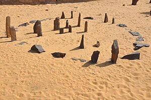 Nabta Playa "calendar circle", reconstructed at Aswan Nubia museum | |
 Nabta Playa Shown within Northeast Africa | |
| Location | Egypt |
|---|---|
| Coordinates | 22°30′29″N 30°43′32″E / 22.507967°N 30.725600°ECoordinates: 22°30′29″N 30°43′32″E / 22.507967°N 30.725600°E |
| Type | Settlement |
| History | |
| Founded | Approximately 7500 BC |
| Periods | Neolithic |


Nabta Playa was once a large internally drained basin in the Nubian Desert, located approximately 800 kilometers south of modern-day Cairo[1] or about 100 kilometers west of Abu Simbel in southern Egypt,[2] 22.51° north, 30.73° east.[3] Today the region is characterized by numerous archaeological sites.[2] The Nabta Playa archaeological site, one of the earliest of the Egyptian Neolithic Period, is dated to circa 7500 BC.[4][5]
Early history[]
Although today the western Egyptian desert is totally dry, this was not always the case. There is good evidence that there were several humid periods in the past (when up to 500 mm of rain would fall per year), the most recent one during the last interglacial and early last glaciation periods which stretched between 130,000 and 70,000 years ago. During this time, the area was a savanna and supported numerous animals such as extinct buffalo and large giraffes, varieties of antelope and gazelle. Beginning around the 10th millennium BCE, this region of the Nubian Desert began to receive more rainfall, filling a lake.[2] Early people may have been attracted to the region due to the source of water.
Archaeological findings may indicate human occupation in the region dating to at least somewhere around the 10th and 8th millennium BC.[2] Fred Wendorf, the site's discoverer, and ethno-linguist Christopher Ehret have suggested that the people who occupied this region at that time were early pastoralists, or like the Saami practiced semi-pastoralism (although this is disputed by other sources because the cattle remains found at Nabta have been shown to be morphologically wild in several studies, and nearby Saharan sites such as in Libya were penning wild Barbary sheep, an animal that was never domesticated). The people of that time consumed and stored wild sorghum, and used ceramics[2] adorned by complicated painted patterns created perhaps by using combs made from fish bone and which belong to a general pottery tradition strongly associated with the southern parts of the Sahara (e.g. of the Khartoum mesolithic and various contemporary sites in Chad) of that period.[2] Analysis of human remains by Fred Wendorf and reported in "Holocene Settlement of the Egyptian Sahara", based on osteological data suggests a sub-Saharan African origin for the site's inhabitants,[6] A dental and skeletal analyses by Joel D. Irish also tentatively suggests a mainly sub-Saharan African affinity and origin for Nabta Playa's inhabitants (with sub-Saharan tendencies most commonly detected), but also possible North African tendencies in some, concluding that, "Henneberg et al. suggest that the Nabta Playa people may have been most similar Negroes from south of the Sahara. The present qualitative dental comparison tentatively supports this conclusion."[7][8] Some researchers, including Christopher Ehret, have suggested a Nilo-Saharan linguistic affinity for the Nabta people.[9]
By the 7th millennium BC, exceedingly large and organized settlements were found in the region, relying on deep wells for sources of water.[2] Huts were constructed in straight rows.[2] Sustenance included fruit, legumes, millets, sorghum and tubers.[2]
Also in the late 7th millennium BC, but a little later than the time referred to above, goats and sheep, apparently imported from Western Asia,[10] appear. Many large hearths also appear.[2]
Organisation[]

Archaeological discoveries reveal that these prehistoric peoples led livelihoods seemingly at a higher level of organization than their contemporaries who lived closer to the Nile Valley.[2] The people of Nabta Playa had above-ground and below-ground stone construction, villages designed in pre-planned arrangements, and deep wells that held water throughout the year.
Findings also indicate that the region was occupied only seasonally, most likely only in the summer period, when the local lake filled with water for grazing cattle.[2] Comparative research indicated that the indigenous inhabitants may have a significantly more advanced knowledge of astronomy and mathematics than previously thought possible.
Religious ties to ancient Egypt[]
By the 6th millennium BC, evidence of a prehistoric religion or cult appears, with a number of sacrificed cattle buried in stone-roofed chambers lined with clay.[2] It has been suggested that the associated cattle cult indicated in Nabta Playa marks an early evolution of Ancient Egypt's Hathor cult. For example, Hathor was worshipped as a nighttime protector in desert regions (see Serabit el-Khadim). To directly quote professors Wendorf and Schild:[2]
... there are many aspects of political and ceremonial life in prehistoric Egypt and the Old Kingdom that reflects a strong impact from Saharan cattle pastoralists ...
Other subterranean complexes are also found in Nabta Playa, one of which included evidence of what Wendorf described as perhaps "the oldest known sculpture in Egypt.[2]
Astronomical observation[]

By the 5th millennium BC these peoples had fashioned what may be among the world's earliest known archeoastronomical devices (roughly contemporary to the Goseck circle in Germany and the Mnajdra megalithic temple complex in Malta). These include alignments of stones that may have indicated the rising of certain stars and a "calendar circle" that indicates the approximate direction of summer solstice sunrise.[11] "Calendar circle" may be a misnomer as the spaces between the pairs of stones in the gates are a bit too wide, and the distances between the gates are too short for accurate calendar measurements."[6] An inventory of Egyptian archaeoastronomical sites for the UNESCO World Heritage Convention evaluated Nabta Playa as having "hypothetical solar and stellar alignments."[12]
Claims for early alignments and star maps[]
Astrophysicist Thomas G. Brophy suggests the hypothesis that the southerly line of three stones inside the Calendar Circle represented the three stars of Orion’s Belt and the other three stones inside the calendar circle represented the shoulders and head stars of Orion as they appeared in the sky. These correspondences were for two dates – circa 4800 BC and at precessional opposition – representing how the sky "moves" long term. Brophy proposes that the circle was constructed and used circa the later date, and the dual date representation was a conceptual representation of the motion of the sky over a precession cycle.
Near the Calendar Circle, which is made of smaller stones, there are alignments of large megalithic stones. The southerly lines of these megaliths, Brophy shows, aligned to the same stars as represented in the Calendar Circle, all at the same epoch, circa 6270 BC. The Calendar Circle correlation with Orion's belt occurred between 6400 BCE and 4900 BC, matching the radio-carbon dating of campfires around the circle.[3]
Recent research[]
A 2007 article by a team of University of Colorado archaeoastronomers and archaeologists (three members had been involved in the original discovery of the site and its astronomical alignment)[13] has responded to the work of Brophy and Rosen, in particular their claims for an alignment with Sirius in 6088 and other alignments which they dated to 6270, saying that these dates were about 1,500 years earlier than the estimated dates. The Sirius alignment in question was originally proposed by Wendorf and Malville,[6] for one of the most prominent alignments of megaliths labelled the "C-line", which they said aligned to the rising of Sirius circa 4820 BCE. Brophy and Rosen showed in 2005 that megalith orientations and star positions reported by Wendorf and Malville were in error, noting that "Given these corrected data, we see that Sirius actually aligned with the C-line circa 6000 BCE. We estimate that 6088 BCE Sirius had a declination of -36.51 degrees, for a rising azimuth exactly on the C-line average".[3] Malville acknowledged the corrections made by Brophy and Rosen, but concluded the C-line of megaliths "may not represent an original set of aligned stele; we refrain from interpreting that alignment."[14]
They also criticised suggestions made by Brophy in his book The Origin Map that there was a representation of the Milky Way as it was in 17,500 BCE and maps of Orion at 16,500 BC, saying "These extremely early dates as well as the proposition that the nomads had contact with extraterrestrial life are inconsistent with the archaeological record. Inference in archaeoastronomy must always be guided and informed by archaeology, especially when substantial field work has been performed in the region.[14]
They propose that the area was first used as what they call a "regional ceremonial centre" around 6100 BC to 5600 BC with people coming from various locations to gather on the dunes surrounding the playa where there is archaeological evidence for gatherings which involved large numbers of cattle bones, as cattle were normally only killed on important occasions. Around 5500 BCE a new, more organised group began to use the site, burying cattle in clay-lined chambers and building other tumuli. Around 4800 BC a stone circle was constructed, with narrow slabs approximately aligned with the summer solstice, near the beginning of the rainy season.
More complex structures followed during a megalith period the researchers dated to between about 4500 BC to 3600 BC. Using their original measurements and measurements by satellite and GPS measurements by Brophy and Rosen they confirmed possible alignments with Sirius, Arcturus, Alpha Centauri and the Belt of Orion. They suggest that there are three pieces of evidence suggesting astronomical observations by the herdsmen using the site, which may have functioned as a necropolis. "The repetitive orientation of megaliths, stele, human burials and cattle burials reveals a very early symbolic connection to the north." Secondly, there is the orientation of the cromlech mentioned above. The third piece of evidence is the fifth millennium alignments of stele to bright stars.[14]
They conclude their report by writing that "The symbolism embedded in the archaeological record of Nabta Playa in the Fifth Millennium BC is very basic, focussed on issues of major practical importance to the nomads: cattle, water, death, earth, sun and stars."[14]
Relative chronology[]
| show |
|---|
See also[]
Notes[]
- ^ Slayman, Andrew L. (May 27, 1998), Neolithic Skywatchers, Archaeological Institute of America
- ^ Jump up to: a b c d e f g h i j k l m n o Wendorf, Fred; Schild, Romuald (November 26, 2000), Late Neolithic megalithic structures at Nabta Playa (Sahara), southwestern Egypt, Comparative Archaeology Web, archived from the original on August 6, 2011
- ^ Jump up to: a b c Brophy, TG; Rosen PA (2005). "Satellite Imagery Measures of the Astronomically Aligned Megaliths at Nabta Playa" (PDF). Mediterranean Archaeology and Archaeometry. 5 (1): 15–24. Archived from the original (PDF) on February 29, 2008.
- ^ Margueron, Jean-Claude (2012). Le Proche-Orient et l'Égypte antiques (in French). Hachette Éducation. p. 380. ISBN 9782011400963.
- ^ Wendorf, Fred; Schild, Romuald (2013). Holocene Settlement of the Egyptian Sahara: Volume 1: The Archaeology of Nabta Playa. Springer Science & Business Media. pp. 51–53. ISBN 9781461506539.
- ^ Jump up to: a b c Wendorf, Fred; Malville, J. McKim (2001), "The Megalith Alignments", in Wendorf, Fred; Schild, Romuald; Nelson, Kit (eds.), In Holocene Settlement of the Egyptian Sahara, vol. I, The archaeology of Nabta Playa, New York: Kluwer Academic/Plenum, pp. 489–502, ISBN 978-0-306-46612-0
- ^ https://www.researchgate.net/publication/232660407_Human_Skeletal_Remains_from_Three_Nabta_Playa_Sites
- ^ Holocene Settlement of the Egyptian Sahara: Volume 1: The Archaeology of Nabta Playa, by By Fred Wendorf, Romuald Schild (chapter 18: Human Skeletal Remains from Three Nabta Playa Sites, by Joel D. Irish), p. 125-128, Kluwer Academic Publishers, 2003
- ^ The Global Prehistory of Human Migration, by Immanuel Ness, p. 103, John Wiley & Sons, 2013
- ^ "Archived copy". Archived from the original on August 6, 2011. Retrieved August 6, 2011.CS1 maint: archived copy as title (link)
- ^ Malville, J. McKim (2015), "Astronomy at Nabta Playa, Egypt", in Ruggles, C.L.N. (ed.), Handbook of Archaeoastronomy and Ethnoastronomy, 2, New York: Springer Science+Business Media, pp. 1079–1091, ISBN 978-1-4614-6140-1
- ^ Belmonte, Juan Antonio (2010), "Ancient Egypt", in Ruggles, Clive; Cotte, Michel (eds.), Heritage Sites of Astronomy and Archaeoastronomy in the context of the UNESCO World Heritage Convention: A Thematic Study, Paris: International Council on Monuments and Sites/International Astronomical Union, pp. 119–129, ISBN 978-2-918086-07-9
- ^ Scott, J (31 March 1998). "Oldest Astronomical Megalith Alignment Discovered in Southern Egypt by Science Team". Boulder, CO: University of Colorado. Archived from the original on 18 May 2014.
- ^ Jump up to: a b c d Malville, J McKim; Schild, R.; Wendorf, F.; Brenmer, R (2007). "Astronomy of Nabta Playa". African Skies/Cieux Africains. 11: 2. Bibcode:2007AfrSk..11....2M.
External links[]
| Wikimedia Commons has media related to Nabta Playa. |
- Article in Scientific American
- Article in Nature
- Ancient Astronomy in Africa
- Megalithic Astronomy at the Ceremonial Center of Nabta Playa
| Authority control |
|
|---|
- Megalithic monuments in the Middle East
- Archaeoastronomy
- Archaeological sites in Egypt
- Kingdom of Kush
- Egyptian calendar
- Prehistoric Egypt