National Capital Region (India)
National Capital Region
NCR | |
|---|---|
Region | |
 Location of the NCR in India | |
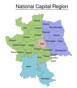 Map of the National Capital Region | |
| Coordinates: 28°39′38″N 77°06′32″E / 28.66056°N 77.10889°ECoordinates: 28°39′38″N 77°06′32″E / 28.66056°N 77.10889°E | |
| Country | |
| States | Haryana Uttar Pradesh Rajasthan |
| Union territory | Delhi |
| Created | 1985[1] |
| Major cities | Faridabad, Ghaziabad, Gurugram, New Delhi, Noida |
| Government | |
| • Regional authority | National Capital Region Planning Board |
| Area | |
| • Total | 55,083 km2 (21,268 sq mi) |
| Population | |
| • Total | 46,069,000 |
| • Density | 840/km2 (2,200/sq mi) |
| Time zone | UTC+05:30 (IST) |
| Website | ncrpb |

The National Capital Region (NCR) is a planning region centred upon the National Capital Territory (NCT) of Delhi in India. It encompasses Delhi and several districts surrounding it from the states of Haryana, Uttar Pradesh and Rajasthan.[4] The NCR and the associated National Capital Region Planning Board were created in 1985 to plan the development of the region and to evolve harmonized policies for the control of land-uses and development of infrastructure in the region.[5] Prominent cities of NCR include Delhi, Faridabad, Ghaziabad, Gurugram, and Noida.
The NCR is a rural-urban region, with a population of over 46,069,000 and an urbanisation level of 62.6%.[3] As well as the cities and towns, the NCR contains ecologically sensitive areas like the Aravalli ridge, forests, wildlife and bird sanctuaries.[6] The Delhi Extended Urban Agglomeration, a part of the NCR, had an estimated GDP of $370 billion (measured in terms of GDP PPP) in 2015–16.[7]
History
The National Capital Region (NCR) and its planning board were created under the National Capital Region Planning Board Act of 1985.[1] That 1985 Act defined the NCR as being the whole of Delhi; the Haryana districts of Gurgaon, Faridabad and Sonipat, Rohtak (then including Jhajjar tehsil) and the Rewari tehsil then in Mahendragarh district; and the Uttar Pradesh districts of Bulandshahr, Muzaffarnagar, Meerut (then including Baghpat tehsil), and Ghaziabad (then including Hapur tehsil), and some part of the Rajasthan district of Alwar.[8][5] The 1985 boundary of the NCR covered an area of 34,144 square kilometres (13,183 sq mi).[3]:3
Prior to the creation of the NCR, an area described as the Delhi Metropolitan Area (DMA) was described in the 1962 Master Plan for Delhi. That plan defined the DMA as comprising the National Capital Territory and the ring towns of Ghaziabad, Faridabad, Ballabhgarh, Gurgaon, Bahadurgarh and Loni, also certain rural areas, which had a population of the somewhat less than 2.1 million in 1951.[9] The following "Master Plan for Delhi", approved in August 1990, added Noida, Bahadurgarh and the then-proposed township of Kundli to the DMA, which consequently covered an area of 3,182 km2.[10]
Gautam Budh Nagar district was created in 1997 out of the existing NCR districts of Ghaziabad and Bulandshahr. The city of Noida was the location of the new district's headquarters.[11] Also in 1997 Baghpat district was created from Baghpat tehsil of Meerut district.[12]
In July 2013, the NCR was expanded to include three more districts, Bhiwani, and Mahendragarh in the state of Haryana, as well as Bharatpur in the state of Rajasthan. This brought the number of districts in the NCR to 19 (outside Delhi NCT), with the total NCR area increasing 34% to 45,887 km2.[13][14] Subsequently, Charkhi Dadri district was separated from Bhiwani district in 2016.[15]
On 9 June 2015 the Government of India approved the inclusion of three more districts in NCR – Jind, Panipat, Karnal in the state of Haryana and Muzaffarnagar in Uttar Pradesh.[16][17][18][19] covering a total area of 50,566 km2.[20] Shamli district of U.P. was added to the NCR in December 2017.[21] As of 2021, there are a total of 24 districts in the NCR, excluding the 11 districts of Delhi.
Proposed extensions
On 9 January 2018, the government of Uttar Pradesh formally proposed the extension of the NCR to cover the districts Aligarh, Bijnor, Hathras and Mathura.[22] It is also pushing to have the district of Agra included in the NCR. Punjab is also forcing to have Patiala, and Mohali included in the NCR. Outskirts of Rajasthan like Bhadra are also included in the Future Extension plans.
Component districts
A total of 24 districts in three neighbouring states of Haryana, Uttar Pradesh and Rajasthan along with whole of the National Capital Territory of Delhi constitute the National Capital Region (NCR) of India.[23]
The areas and populations (per 2011 census, prior to the addition of Muzaffarnagar, Jind, Karnal and Shamli) of these component districts are set out below:[4][3]:3, 6
| State/UT | Districts | Area (km2) |
Population (in thousands) |
|---|---|---|---|
| Delhi | Central Delhi | 1,483 | 16,788 |
| East Delhi | |||
| New Delhi | |||
| North Delhi | |||
| North East Delhi | |||
| North West Delhi | |||
| Shahdara | |||
| South Delhi | |||
| South East Delhi | |||
| South West Delhi | |||
| West Delhi | |||
| Haryana | Bhiwani | 25,327 | 11,031 |
| Charkhi Dadri | |||
| Faridabad | |||
| Gurgaon | |||
| Jhajjar | |||
| Jind | |||
| Karnal | |||
| Mahendragarh | |||
| Nuh | |||
| Palwal | |||
| Panipat | |||
| Rewari | |||
| Rohtak | |||
| Sonipat | |||
| Rajasthan | Alwar | 13,447 [20] |
3,674 |
| Bharatpur | |||
| Uttar Pradesh | Baghpat | 14,727 | 14,576 |
| Bulandshahr | |||
| Gautam Buddh Nagar | |||
| Ghaziabad | |||
| Hapur | |||
| Meerut | |||
| Muzaffarnagar | |||
| Shamli | |||
| Total | 54,984 | 46,069 | |
Regional planning
The planning body for the region is the National Capital Region Planning Board (NCRPB). It has issued two regional plans, the "Regional Plan 2001, National Capital Region" approved in 1988,[24] and the "Regional Plan 2021, National Capital Region" approved in 2005.[25] Topics covered by the 2001 plan included transport, telecommunications, power and water supply, waste and sewerage, education, health, the environment, housing and the "counter magnet" areas. The 2021 plan extended these with the additional topics of social infrastructure, heritage, tourism, rural development, and disaster management.
The 51% of pollution in NCR is caused by the industrial pollution, 27% by vehicles and 8% by crop burning, consequently there are plans to create a 1,600 km long and 5 km wide The Great Green Wall of Aravalli green ecological corridor along Aravalli range from Gujarat to Delhi to be connected to Sivalik hill range with the planting of 1.35 billion (135 crore) new native trees over 10 years.[26] About 46% of the National Capital Region, home to 40 to 50 million people, is not connected to sewage networks. Sewage from these areas flows into stormwater drains that empty directly into the Yamuna.[27]
Transport
The National Capital Region Transport Corporation (NCRTC), a Joint Venture company of the Government of India and states of Haryana, Rajasthan and Uttar Pradesh and the National Capital Territory (NCT) of Delhi, is mandated for implementing the Regional Rapid Transit System (RRTS) project across the National Capital Region (NCR), ensuring a balanced and sustainable urban development through better connectivity and access.
The Union Cabinet approved constitution of the NCRTC under the Companies Act, 1956 in July, 2013 for designing, developing, implementing, financing, operating and maintaining Regional Rapid Transit system (RRTS) in the NCR to provide comfortable and fast transit to the NCR towns and meet the high growth in transport demand. Accordingly, NCRTC has been incorporated on 1 August 2013. Vinay Kumar Singh was appointed as the first regular Managing Director of NCRTC in July 2016.[28]
Out of the 8 identified RRTS Corridors, three were prioritized for implementation by Planning Commission. These three are:
Central National Capital Region
The 2001 regional plan defined the "Delhi Metropolitan Area" (DMA) as including Ghaziabad, Noida, Faridabad, Gurgaon, Kundli and Sonipat. The 2021 plan renamed the area as the "Central National Capital Region" (CNCR), covering about 2,000 km2 (770 sq mi) in addition to the 1,483 km2 (573 sq mi) of the NCT of Delhi.[29]
The 2021 plan estimated the 2001 population of the CNCR outside of Delhi to be over 2.8 million, while Delhi's population was 13.8 million, yielding a total CNCR population of 16.6 million.[30] As of 2016 the most recent population estimates have spanned 25.7 to 26.5 million people.[31][32]
Counter magnets
The 1985 Act (§2.c and §8.f) gives the NCRCB has the ability to select districts outside of the NCR to act as counter magnets, with a view to developing them further.[5]:2, 10 Counter-magnet cities are identified as those that can be developed as alternative centres of growth and attract migrants to them rather than Delhi.[24]:121 The criteria for selecting counter magnet towns are: that they should have their own established roots and potential of growth,[24]:121 and should not be centres of either religious, strategic or environmental importance.[citation needed] The counter magnet cities should be given priority when allocating funding for development of land, housing and infrastructure.[24]:126
These cities, with their distances from the Delhi, are:[4]
In Haryana state
- Hisar, 160 km
- Ambala, 200 km
In Madhya Pradesh state
- Gwalior (particularly Gwalior West), 320 km
In Punjab state
- Patiala, 230 km
In Rajasthan state
In Uttar Pradesh state
In Uttarakhand
- Dehradun, 240 km
See also
References
- ^ Jump up to: a b "Rationale". ncrpb.nic.in. NCR Planning Board. Archived from the original on 16 December 2012. Retrieved 5 March 2013.
The National Capital Region (NCR) in India was constituted under the NCRPB Act, 1985
- ^ "NCR Constituent Areas". National Capital Region Planning Board.
- ^ Jump up to: a b c d "Census 2011" (PDF). National Capital Region Planning Board. National Informatics Centre. p. 3. Archived from the original (PDF) on 6 April 2016. Retrieved 26 March 2016.
- ^ Jump up to: a b c "NCR Constituent Areas". National Capital Region Planning Board. Archived from the original on 24 December 2017.
- ^ Jump up to: a b c "The Gazette of India, National Capital Region Planning Board Act of 1985" (PDF). NCR Planning Board. 1985. Archived from the original (PDF) on 28 August 2012. Retrieved 5 March 2017.
- ^ "NCR expands, planning lags". The Indian Express. 18 January 2014. Archived from the original on 20 March 2017. Retrieved 19 March 2017.
- ^ "With GDP of $370 billion, Delhi-NCR muscles out Mumbai as economic capital of India". The Financial Express. 29 November 2016. Archived from the original on 10 July 2017. Retrieved 14 July 2017.
- ^ "NCR Planning Board Act of 1985" (PDF). 1985.
- ^ "Master Plan for Delhi" (PDF). rgplan.org. Delhi Development Authority. 1 September 1962. Archived (PDF) from the original on 11 September 2016. Retrieved 19 March 2017.
- ^ "Master Plan for Delhi" (PDF). Delhi Development Authority. August 1990. p. 8. Archived (PDF) from the original on 28 August 2017. Retrieved 19 March 2017.
- ^ "Brief Industrial Profile of Gautam Budh Nagar" (PDF). Government of India Micro, Small and Medium Enterprises. 14 August 2012. p. 1. Archived (PDF) from the original on 23 November 2018. Retrieved 28 July 2018.
- ^ "Census of India 2011 – Uttar Pradesh – District Census Handbook – Baghpat" (PDF). Office of the Registrar General & Census Commissioner, India. 2011. p. 9. Archived (PDF) from the original on 14 November 2015. Retrieved 7 July 2016.
- ^ "The Organisation and Administration" (PDF). Ministry of Urban Development. Government of India. p. 32. Archived from the original (PDF) on 8 April 2017. Retrieved 7 April 2017.
Government of India vide Notification dated 1.10.2013 has included Bhiwani and Mahendragarh districts of the State of Haryana and Bharatpur district of the State of Rajasthan
- ^ "3 more districts enter National Capital Region fold – The Times of India". The Times of India. 2 July 2013. Archived from the original on 3 October 2016. Retrieved 4 January 2015.
- ^ "Charki Dadri notified as 22nd district of Haryana". The Times of India. 5 December 2016. Archived from the original on 6 December 2016. Retrieved 13 July 2017.
- ^ "NCR gets bigger; Jind, Karnal and Muzaffarnagar districts added". The Economic Times. Archived from the original on 12 June 2015. Retrieved 28 July 2015.
- ^ "NCR to now include these 3 new districts". Archived from the original on 9 June 2015. Retrieved 9 June 2015.
- ^ Business Standard. "NCR to now include 3 new districts – Part – 2". Archived from the original on 5 March 2016. Retrieved 28 July 2015.
- ^ "Jind and Karnal now at NCR – हरियाणा के 2 और जिले NCR में Amar Ujala". delhincr.amarujala.com. Archived from the original on 21 January 2014.
- ^ Jump up to: a b "Sub-Regional Plan for Haryana Sub-Region of NCR-2021" (PDF). Department of Town & Country Planning. Government of Haryana. 10 June 2016. p. 2. Archived (PDF) from the original on 12 February 2016. Retrieved 7 April 2017.
- ^ "NCR-shamli-inclusion". The Hindu. 5 December 2017.
- ^ Dabas, Harveer (9 January 2018). "UP govt sends proposal to include Bijnor, Mathura, Aligarh & Hathras in NCR". The Times of India. Archived from the original on 10 January 2018. Retrieved 9 January 2018.
- ^ National Capital Region Planning Board Archived 16 December 2012 at the Wayback Machine. Ncrpb.nic.in. Retrieved on 16 July 2013.
- ^ Jump up to: a b c d "Regional Plan 2001, National Capital Region" (PDF). NCR Planning Board. 3 November 1988. Archived (PDF) from the original on 8 March 2017. Retrieved 7 March 2017.
the future interceptors of migratory flow
- ^ "Regional Plan 2021, Background". ncrpb.nic.in. NCR Planning Board. Archived from the original on 18 May 2017. Retrieved 7 March 2017.
- ^ Want govt to build 1600 km green wall along Aravalli, Indian Express, 24 December 2019.
- ^ "No sewerage in 46% of NCR". The Times of India. Archived from the original on 4 May 2014. Retrieved 28 July 2015.
- ^ "Railway officer Vinay Kumar Singh to head NCRTC". The Economic Times. 21 February 2016. Retrieved 25 May 2020.
- ^ "Evaluation Study of DMA Towns in National Capital Region" (PDF). Town and Country Planning Organisation. Ministry of Urban Development. September 2007. Archived from the original (PDF) on 20 March 2017. Retrieved 19 March 2017.
- ^ "Regional Plan 2021 – Chapter 4, Demographic Profile and Settlement Pattern" (PDF). NCR Planning Board. p. 16. Archived (PDF) from the original on 20 March 2017. Retrieved 19 March 2017.
- ^ Demographia (April 2016). Demographia World Urban Areas (PDF) (12th ed.). Archived from the original (PDF) on 3 May 2018. Retrieved 17 November 2016. (excludes Kondli)
- ^ "The World's Cities in 2016" (PDF). United Nations. October 2016. p. 4. Archived (PDF) from the original on 12 January 2017. Retrieved 4 March 2017.
External links
- National Capital Region Planning Board
- Famous Temples in Delhi NCR
- NCR map
- Official area information of districts of India
- Bulandshahr Official Website
- Bhiwani Official Site
- Mahendragarh Official Site
- National Capital Region (India): Counter-Magnet Areas on Indpaedia
- National Capital Region Urban Infrastructure Financing Facility on Asian Development Bank
| Authority control |
|
|---|
- Geography of Delhi
- National Capital Region (India)
- WikiProject India members