[3] Name on the Register[4]
Image
Date listed[5]
Location
City or town
Description
1
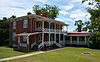
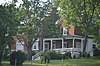
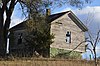
James Alexander House
September 16, 1982 (#82004543 ) North of Spottswood on Almo Chapel Rd. 37°57′53″N 79°12′12″W / 37.964722°N 79.203333°W / 37.964722; -79.203333 (James Alexander House ) Spottswood
2
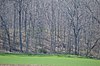
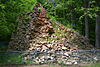
Archeological Site No. AU-154
December 13, 1985 (#85003171 ) Paine Run Hollow Rd. at the mouth of Paine Run Hollow[6] 38°11′56″N 78°47′44″W / 38.198889°N 78.795556°W / 38.198889; -78.795556 (Archeological Site No. AU-154 ) Grottoes
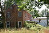
3
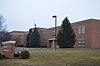
Augusta County Training School
June 19, 1986 (#86001400 ) Cedar Green Rd. 38°08′49″N 79°07′54″W / 38.146944°N 79.131667°W / 38.146944; -79.131667 (Augusta County Training School ) Cedar Green
4
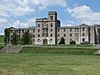
Augusta Military Academy
February 10, 1983 (#83003258 ) North of Staunton on U.S. Route 11 38°14′16″N 78°58′39″W / 38.237778°N 78.977500°W / 38.237778; -78.977500 (Augusta Military Academy ) Fort Defiance
5
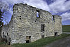
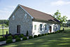
Augusta Stone Church
May 9, 1973 (#73001994 ) U.S. Route 11 38°14′18″N 78°58′32″W / 38.238333°N 78.975556°W / 38.238333; -78.975556 (Augusta Stone Church ) Fort Defiance
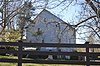
6
Bare House and Mill
November 21, 2002 (#02001364 ) 157 Wilda Rd. 38°01′23″N 79°05′42″W / 38.023056°N 79.095000°W / 38.023056; -79.095000 (Bare House and Mill ) Stuarts Draft
7
Bethel Green
August 26, 1982 (#82004539 ) Howardsville Rd. 38°02′32″N 79°10′33″W / 38.042222°N 79.175833°W / 38.042222; -79.175833 (Bethel Green ) Greenville
8
Blackrock Springs Site
December 13, 1985 (#85003169 ) Source of Paine Run[7] 38°12′30″N 78°45′09″W / 38.208333°N 78.752500°W / 38.208333; -78.752500 (Blackrock Springs Site ) Grottoes
9
Chapel Hill
November 16, 1978 (#78003006 ) East of Mint Spring on White Hill Rd. 38°03′56″N 79°04′17″W / 38.065556°N 79.071389°W / 38.065556; -79.071389 (Chapel Hill ) Mint Spring
10
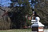
Clover Mount
September 16, 1982 (#82004540 ) West of Greenville on Pilson Rd. 37°59′59″N 79°12′23″W / 37.999722°N 79.206389°W / 37.999722; -79.206389 (Clover Mount ) Greenville
11
Coiner House
March 30, 1978 (#78003005 ) Northwest of Crimora off Rockfish Rd. 38°10′00″N 78°51′54″W / 38.166667°N 78.865000°W / 38.166667; -78.865000 (Coiner House ) Crimora
12
Craigsville School
February 27, 1985 (#85000383 ) Railroad Ave. 38°04′46″N 79°22′47″W / 38.079444°N 79.379722°W / 38.079444; -79.379722 (Craigsville School ) Craigsville
13
Crimora School
February 27, 1985 (#85000384 ) New Hope-Crimora Rd. 38°09′18″N 78°51′09″W / 38.155000°N 78.852500°W / 38.155000; -78.852500 (Crimora School ) Crimora
14
Deerfield School
June 19, 1986 (#86001402 ) Marble Valley Rd. 38°11′41″N 79°24′22″W / 38.194722°N 79.406111°W / 38.194722; -79.406111 (Deerfield School ) Deerfield
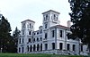
15
Estaline Schoolhouse
February 27, 1985 (#85000385 ) Estaline Valley Rd. 38°03′46″N 79°21′26″W / 38.062778°N 79.357361°W / 38.062778; -79.357361 (Estaline Schoolhouse )
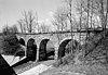
16
Folly
October 25, 1973 (#73001995 ) South of Staunton on U.S. Route 11 38°05′26″N 79°05′41″W / 38.090556°N 79.094722°W / 38.090556; -79.094722 (Folly ) Staunton
17
Glebe Burying Ground
October 1, 1985 (#85002722 ) South of Swoope on Glebe School Rd. 38°06′34″N 79°13′20″W / 38.109306°N 79.222222°W / 38.109306; -79.222222 (Glebe Burying Ground ) Swoope
18
Glebe Schoolhouse
February 27, 1985 (#85000386 ) Glebe School Rd. 38°06′37″N 79°13′15″W / 38.110278°N 79.220833°W / 38.110278; -79.220833 (Glebe Schoolhouse ) Summerdean
19
Greenwood-Afton Rural Historic District
May 6, 2011 (#11000258 ) Roughly 5 miles (8.0 km) to 7 miles (11 km) north and south of Interstate 64 38°01′42″N 78°52′09″W / 38.028333°N 78.869167°W / 38.028333; -78.869167 (Greenwood-Afton Rural Historic District ) Greenwood Boundaries modified on February 8, 2016 . Extends into Albemarle and Nelson counties
20
Hanger Mill
November 8, 1991 (#91001596 ) Junction of U.S. Route 250 and Hangers Mill Rd. 38°13′10″N 79°08′09″W / 38.219444°N 79.135833°W / 38.219444; -79.135833 (Hanger Mill ) Churchville
21
Harnsberger Octagonal Barn
July 8, 1982 (#82004541 ) Snowflake Mill Rd. 38°15′44″N 78°51′50″W / 38.262361°N 78.863889°W / 38.262361; -78.863889 (Harnsberger Octagonal Barn ) Grottoes
22
Harper House
February 1, 2006 (#05001623 ) 3029 U.S. Route 340 38°02′25″N 79°01′10″W / 38.040139°N 79.019583°W / 38.040139; -79.019583 (Harper House ) Stuarts Draft
23
Intervale
February 14, 1985 (#85000296 ) Morris Mill Rd. 38°11′52″N 79°11′20″W / 38.197778°N 79.188889°W / 38.197778; -79.188889 (Intervale ) Swoope
24
Long Glade Farm
January 22, 1996 (#95001560 ) Mt. Solon Rd., south of the junction with Old Quarry Rd. 38°16′54″N 79°04′22″W / 38.281667°N 79.072778°W / 38.281667; -79.072778 (Long Glade Farm ) Mount Solon
25
Maple Front Farm
August 16, 2010 (#10000562 ) 439 Cale Spring Rd. 38°03′33″N 79°14′28″W / 38.059028°N 79.241111°W / 38.059028; -79.241111 (Maple Front Farm ) Middlebrook
26
Middlebrook High School
February 27, 1985 (#85000387 ) Cherry Grove Rd. 38°03′01″N 79°12′45″W / 38.050278°N 79.212500°W / 38.050278; -79.212500 (Middlebrook High School ) Middlebrook
27
Middlebrook Historic District
February 10, 1983 (#83003259 ) Junction of State Route 252 and Mish Barn Rd. 38°03′06″N 79°12′48″W / 38.051694°N 79.213333°W / 38.051694; -79.213333 (Middlebrook Historic District ) Middlebrook
28
Middlebrook School
February 27, 1985 (#85000388 ) Cherry Grove Rd. 38°03′02″N 79°12′44″W / 38.050556°N 79.212222°W / 38.050556; -79.212222 (Middlebrook School ) Middlebrook
29
A. J. Miller House
July 8, 1982 (#82004542 ) Sinking Springs Rd. 38°01′25″N 79°13′56″W / 38.023611°N 79.232222°W / 38.023611; -79.232222 (A. J. Miller House ) Middlebrook
30
Hannah Miller House
May 24, 1979 (#79003028 ) North of Mossy Creek off Mossy Creek Rd. 38°21′34″N 79°01′46″W / 38.359444°N 79.029583°W / 38.359444; -79.029583 (Hannah Miller House ) Mossy Creek
31
Henry Miller House
May 23, 1979 (#79003029 ) East of Mossy Creek on State Route 42 38°21′27″N 79°01′40″W / 38.357500°N 79.027778°W / 38.357500; -79.027778 (Henry Miller House ) Mossy Creek
32
Henry Mish Barn
February 10, 1983 (#83003260 ) North of Middlebrook on Mish Barn Rd. 38°03′54″N 79°13′30″W / 38.065000°N 79.225000°W / 38.065000; -79.225000 (Henry Mish Barn ) Middlebrook
33
Moffett's Creek Schoolhouse
February 27, 1985 (#85000389 ) Mt. Hermon Rd. 38°00′10″N 79°18′27″W / 38.002639°N 79.307500°W / 38.002639; -79.307500 (Moffett's Creek Schoolhouse ) Newport
34
Mt. Airy
August 22, 2012 (#12000538 ) Access road off Technology Dr., southeast of the Augusta County Government Center 38°11′22″N 79°00′44″W / 38.189306°N 79.012361°W / 38.189306; -79.012361 (Mt. Airy ) Verona home of American folk artist Grandma Moses
35
Mt. Meridian Schoolhouse
February 27, 1985 (#85000390 ) Rockfish Rd. 38°15′35″N 78°51′38″W / 38.259722°N 78.860694°W / 38.259722; -78.860694 (Mt. Meridian Schoolhouse ) Mt. Meridian
36
Mount Pleasant
October 30, 1989 (#89001792 ) 879 Middle River Rd. 38°14′36″N 79°05′10″W / 38.243333°N 79.086111°W / 38.243333; -79.086111 (Mount Pleasant ) Staunton
37
Mt. Sidney Historic District
October 30, 1998 (#98001313 ) U.S. Route 11 , Mt. Sidney School Ln., and Pottery Shop Ln.38°15′22″N 78°57′36″W / 38.256111°N 78.960000°W / 38.256111; -78.960000 (Mt. Sidney Historic District ) Mt. Sidney
38
Mt. Sidney School
February 27, 1985 (#85000391 ) U.S. Route 11 38°15′22″N 78°57′43″W / 38.256111°N 78.961944°W / 38.256111; -78.961944 (Mt. Sidney School ) Mt. Sidney
39
Mt. Torry Furnace
February 25, 1974 (#74002231 ) Southwest of Waynesboro on Mt. Torry Rd. in the George Washington National Forest 37°56′43″N 78°57′53″W / 37.945278°N 78.964722°W / 37.945278; -78.964722 (Mt. Torry Furnace ) Sherando
40
Mt. Zion Schoolhouse
February 27, 1985 (#85000392 ) Freemason Run Rd. 38°20′13″N 79°07′36″W / 38.336944°N 79.126667°W / 38.336944; -79.126667 (Mt. Zion Schoolhouse ) Mount Solon
41
New Hope High School
February 27, 1985 (#85000393 ) Battlefield Rd. 38°12′04″N 78°54′14″W / 38.201111°N 78.903889°W / 38.201111; -78.903889 (New Hope High School ) New Hope
42
North River High School
February 27, 1985 (#85000394 ) State Route 42 38°18′54″N 79°04′45″W / 38.315000°N 79.079167°W / 38.315000; -79.079167 (North River High School ) Moscow
43
Old Providence Stone Church
December 5, 1972 (#72001383 ) Junction of Spottswood and Old Providence Rds. 37°57′40″N 79°13′35″W / 37.961111°N 79.226250°W / 37.961111; -79.226250 (Old Providence Stone Church ) Spottswood
44
Paine Run Rockshelter
December 13, 1985 (#85003170 ) Southern side of Paine Run Hollow[8] 38°11′54″N 78°47′34″W / 38.198333°N 78.792778°W / 38.198333; -78.792778 (Paine Run Rockshelter ) Grottoes
45
Lewis Shuey House
February 10, 1983 (#83003261 ) South of Swoope on Shuey Rd. 38°07′07″N 79°13′38″W / 38.118611°N 79.227361°W / 38.118611; -79.227361 (Lewis Shuey House ) Swoope
46
Skyline Drive Historic District
April 28, 1997 (#97000375 ) Shenandoah National Park , from the northern entrance station at Front Royal to the southern entrance station at the Rockfish Gap 38°08′32″N 78°46′48″W / 38.142222°N 78.780000°W / 38.142222; -78.780000 (Skyline Drive Historic District ) Luray
47
Sugar Loaf Farm
July 9, 1991 (#91000884 ) West of the junction of Sugar Loaf and Eidson Creek Rds. 38°06′09″N 79°10′25″W / 38.102500°N 79.173611°W / 38.102500; -79.173611 (Sugar Loaf Farm ) Staunton
48
Swannanoa
October 1, 1969 (#69000221 ) South of the junction of U.S. Route 250 and the Howardsville Turnpike 38°01′41″N 78°52′08″W / 38.028056°N 78.868889°W / 38.028056; -78.868889 (Swannanoa ) Waynesboro Extends into Nelson County
49
May 11, 2018 (#100002438 ) 7 Old Staunton Rd. 38°00′20″N 79°09′19″W / 38.005694°N 79.155139°W / 38.005694; -79.155139 (Fannie Thompson House ) Greenville
50
Tinkling Spring Presbyterian Church
April 11, 1973 (#73001993 ) Tinkling Spring Rd. south of its junction with Lifecore Dr. 38°05′06″N 78°58′57″W / 38.085000°N 78.982500°W / 38.085000; -78.982500 (Tinkling Spring Presbyterian Church ) Fishersville
51
Valley Railroad Stone Bridge
November 19, 1974 (#74002105 ) South of Jolivue off U.S. Route 11 38°05′22″N 79°04′40″W / 38.089444°N 79.077778°W / 38.089444; -79.077778 (Valley Railroad Stone Bridge ) Jolivue
52
Verona School
February 27, 1985 (#85000395 ) U.S. Route 11 38°12′15″N 79°00′26″W / 38.204167°N 79.007222°W / 38.204167; -79.007222 (Verona School ) Verona
53
Walker's Creek Schoolhouse
February 27, 1985 (#85000396 ) Walker Creek Rd. 38°00′57″N 79°19′53″W / 38.015972°N 79.331389°W / 38.015972; -79.331389 (Walker's Creek Schoolhouse ) Newport
54
West View Schoolhouse
February 27, 1985 (#85000397 ) Broad Run and Westview School Rds. 38°16′04″N 78°54′54″W / 38.267778°N 78.915000°W / 38.267778; -78.915000 (West View Schoolhouse ) Weyers Cave
55
Weyers Cave School
February 27, 1985 (#85000398 ) State Route 276 38°17′18″N 78°54′32″W / 38.288333°N 78.908889°W / 38.288333; -78.908889 (Weyers Cave School ) Weyers Cave