National Register of Historic Places listings in Northumberland County, Virginia

Location of Northumberland County in Virginia
This is a list of the National Register of Historic Places listings in Northumberland County, Virginia.
This is intended to be a complete list of the properties and districts on the National Register of Historic Places in Northumberland County, Virginia, United States. The locations of National Register properties and districts for which the latitude and longitude coordinates are included below, may be seen in a Google map.[1]
There are 26 properties and districts listed on the National Register in the county.
- This National Park Service list is complete through NPS recent listings posted February 11, 2022.[2]
Current listings[]
| [3] | Name on the Register[4] | Image | Date listed[5] | Location | City or town | Description |
|---|---|---|---|---|---|---|
| 1 | The Academy |  |
November 18, 1997 (#97001400) |
Junction of Main St. and St. Stephen's Ln. 37°55′13″N 76°28′28″W / 37.920139°N 76.474444°W | Heathsville | |
| 2 | The Anchorage |  |
March 17, 1995 (#95000245) |
Northern side of Balls Neck Rd., 1 mile (1.6 km) east of its junction with Waddeys Rd. 37°47′20″N 76°20′19″W / 37.788861°N 76.338611°W | Kilmarnock | |
| 3 | Bluff Point Graded School No. 3 |  |
June 3, 2009 (#09000396) |
2595 Bluff Point Rd. 37°42′31″N 76°20′12″W / 37.708611°N 76.336528°W | Kilmarnock | |
| 4 | CLAUD W. SOMERS (skipjack) | 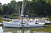 |
October 7, 2005 (#05000526) |
504 Main St. 37°50′38″N 76°16′33″W / 37.843889°N 76.275833°W | Reedville | |
| 5 | Claughton-Wright House | 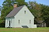 |
May 23, 1997 (#97000491) |
2 miles (3.2 km) northeast of the junction of Melrose and Lewisetta Rds. 37°59′41″N 76°30′46″W / 37.994861°N 76.512639°W | Lewisetta | |
| 6 | Clifton |  |
May 19, 2004 (#04000477) |
49 Clifton Ave. 37°42′49″N 76°22′14″W / 37.713611°N 76.370556°W | Kilmarnock | |
| 7 | Coan Baptist Church |  |
March 17, 1995 (#95000239) |
Coan Church Rd., east of its junction with Coan Stage Rd. 37°55′31″N 76°30′50″W / 37.925278°N 76.513889°W | Heathsville | |
| 8 | Cobbs Hall |  |
July 5, 2001 (#01000699) |
582 Cobbs Hall Ln. 37°44′38″N 76°20′23″W / 37.743889°N 76.339722°W | Kilmarnock | |
| 9 | Ditchley |  |
September 24, 1992 (#92001272) |
Northern side of Ditchley Rd., 2,000 feet (610 m) east of its junction with Apple Grove Rd. 37°44′03″N 76°20′05″W / 37.734167°N 76.334722°W | Kilmarnock | |
| 10 | ELVA C (Deck Boat) |  |
October 4, 2005 (#05001160) |
504 Main St. 37°50′37″N 76°16′33″W / 37.843611°N 76.275833°W | Reedville | |
| 11 | Heathsville Historic District |  |
February 26, 1992 (#92000053) |
U.S. Route 360 at its junction with State Route 201 and Spring Rd. 37°55′07″N 76°28′23″W / 37.918611°N 76.473056°W | Heathsville | |
| 12 | Holley Graded School |  |
December 19, 1990 (#89001934) |
U.S. Route 360 north of its junction with Lake Rd. 37°57′44″N 76°31′09″W / 37.962222°N 76.519028°W | Lottsburg | |
| 13 | Howland Chapel School |  |
January 25, 1991 (#90002206) |
Junction of State Route 201 and Knights Run Rd. 37°52′17″N 76°27′23″W / 37.871250°N 76.456389°W | Heathsville | |
| 14 | Hurstville |  |
September 24, 1992 (#92001264) |
Eastern side of Balls Neck Rd., 3,500 feet (1,100 m) south of its junction with Shiloh School Rd. 37°45′41″N 76°19′11″W / 37.761389°N 76.319722°W | Kilmarnock | |
| 15 | Kirkland Grove Campground |  |
October 15, 1992 (#92001391) |
Kirkland Grove Ln., 1.6 miles (2.6 km) south of Heathsville 37°54′02″N 76°29′08″W / 37.900556°N 76.485556°W | Heathsville | |
| 16 | Oakley |  |
January 27, 1999 (#99000073) |
28 Back St. 37°55′06″N 76°28′28″W / 37.918472°N 76.474444°W | Heathsville | |
| 17 | Reedville Historic District | 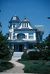 |
August 16, 1984 (#84003556) |
Main St. 37°50′31″N 76°16′34″W / 37.841944°N 76.276111°W | Reedville | |
| 18 | Rice's Hotel |  |
October 15, 1992 (#92001389) |
Junction of Back St. and Judicial Pl. 37°55′01″N 76°28′23″W / 37.916944°N 76.473056°W | Heathsville | |
| 19 | St. Stephen's Church | 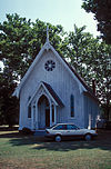 |
December 28, 1979 (#79003060) |
U.S. Route 360 37°55′11″N 76°28′26″W / 37.919722°N 76.473889°W | Heathsville | |
| 20 | Shalango |  |
November 6, 1986 (#86003135) |
Sandy Point Rd. 37°49′23″N 76°19′12″W / 37.823056°N 76.320000°W | Wicomico Church | |
| 21 | Shiloh School |  |
January 22, 1992 (#91001976) |
Junction of Balls Neck and Shiloh School Rds. 37°46′05″N 76°19′50″W / 37.768194°N 76.330417°W | Kilmarnock | |
| 22 | Smith Point Light Station |  |
December 2, 2002 (#02001437) |
37°52′47″N 76°11′01″W / 37.879722°N 76.183611°W | ||
| 23 | Springfield |  |
December 23, 1979 (#79003059) |
U.S. Route 360 37°55′31″N 76°28′48″W / 37.925278°N 76.480000°W | Heathsville | |
| 24 | Sunnyside |  |
May 23, 1996 (#96000580) |
Southern side of U.S. Route 360, east of its junction with State Route 201 37°54′52″N 76°28′02″W / 37.914572°N 76.467361°W | Heathsville | |
| 25 | Versailles |  |
February 27, 1997 (#97000204) |
U.S. Route 360, 0.25 miles (0.40 km) west of its junction with State Route 200 37°53′14″N 76°21′07″W / 37.887222°N 76.351944°W | Burgess | |
| 26 | Wheatland |  |
November 15, 1988 (#87000015) |
Lewisetta Rd. 38°00′02″N 76°30′41″W / 38.000556°N 76.511389°W | Callao |

See also[]
| Wikimedia Commons has media related to National Register of Historic Places in Northumberland County, Virginia. |
- List of National Historic Landmarks in Virginia
- National Register of Historic Places listings in Virginia
References[]
- ^ The latitude and longitude information provided in this table was derived originally from the National Register Information System, which has been found to be fairly accurate for about 99% of listings. Some locations in this table may have been corrected to current GPS standards.
- ^ National Park Service, United States Department of the Interior, "National Register of Historic Places: Weekly List Actions", retrieved February 11, 2022.
- ^ Numbers represent an alphabetical ordering by significant words. Various colorings, defined here, differentiate National Historic Landmarks and historic districts from other NRHP buildings, structures, sites or objects.
- ^ "National Register Information System". National Register of Historic Places. National Park Service. April 24, 2008.
- ^ The eight-digit number below each date is the number assigned to each location in the National Register Information System database, which can be viewed by clicking the number.

Municipalities and communities of Northumberland County, Virginia, United States | ||
|---|---|---|
County seat: Heathsville | ||
| Town |
|  |
| CDP |
| |
| Other communities |
| |
| Footnotes | ‡This populated place also has portions in an adjacent county or counties | |
| ||
Categories:
- National Register of Historic Places in Northumberland County, Virginia
- Lists of National Register of Historic Places in Virginia by county