[3] Name on the Register[4]
Image
Date listed[5]
Location
City or town
Description
1
Upload image May 27, 2021 (#100006575 ) 190-194 2nd St. 37°34′59″N 79°02′54″W / 37.5831°N 79.0482°W / 37.5831; -79.0482 (Amherst Baptist Church ) Amherst
2
Bear Mountain Indian Mission School
February 21, 1997 (#97000152 ) Southwestern corner of the junction of Kenmore and Indian Mission Rds. 37°34′22″N 79°07′37″W / 37.5728°N 79.1269°W / 37.5728; -79.1269 (Bear Mountain Indian Mission School ) Amherst
3
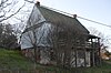
Brick House
February 1, 2006 (#05001620 ) 854 Fletcher's Level Rd. 37°38′38″N 79°01′17″W / 37.6439°N 79.0214°W / 37.6439; -79.0214 (Brick House ) Clifford
4
Brightwells Mill Complex
August 15, 2016 (#16000527 ) 586 Brightwells Mill Rd. 37°27′31″N 79°02′51″W / 37.4586°N 79.0475°W / 37.4586; -79.0475 (Brightwells Mill Complex ) Madison Heights
5
Clifford-New Glasgow Historic District
March 12, 2012 (#12000122 ) State Route 151 and Fletchers Level Rd.37°38′25″N 79°01′20″W / 37.640278°N 79.022222°W / 37.640278; -79.022222 (Clifford-New Glasgow Historic District ) Clifford
6
Dulwich Manor
May 28, 2013 (#13000335 ) 550 U.S. Route 60 37°34′27″N 79°02′30″W / 37.57403°N 79.04167°W / 37.57403; -79.04167 (Dulwich Manor ) Amherst
7
Edge Hill
May 15, 2008 (#08000418 ) 1380 Edgehill Plantation Rd. 37°30′11″N 78°55′33″W / 37.503056°N 78.925833°W / 37.503056; -78.925833 (Edge Hill ) Gladstone
8
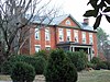
Edgewood
March 14, 2008 (#08000200 ) 591 Puppy Creek Rd. 37°38′38″N 79°09′34″W / 37.643750°N 79.159444°W / 37.643750; -79.159444 (Edgewood ) Amherst
9
Edgewood
August 16, 2006 (#06000706 ) 138 Garland Ave. 37°34′55″N 79°03′20″W / 37.581806°N 79.055417°W / 37.581806; -79.055417 (Edgewood ) Amherst
10
April 20, 2018 (#100002354 ) 925 Buffalo Springs Turnpike 37°38′43″N 79°13′15″W / 37.645278°N 79.220833°W / 37.645278; -79.220833 (El Bethel Methodist Church ) Amherst
11
Elon Village Library
November 22, 2016 (#16000793 ) Corner of Camden and Younger Drs. 37°30′50″N 79°11′40″W / 37.513889°N 79.194444°W / 37.513889; -79.194444 (Elon Village Library ) Amherst
12
April 27, 2018 (#100002391 ) 205 Sandidges Rd. 37°39′44″N 79°08′45″W / 37.662361°N 79.145833°W / 37.662361; -79.145833 (Emmanuel Baptist Church ) Amherst
13
Fairview
June 3, 2009 (#09000391 ) 2416 Lowesville Rd. 37°41′58″N 79°03′56″W / 37.699444°N 79.065556°W / 37.699444; -79.065556 (Fairview ) Amherst
14
Forest Hill
March 22, 2007 (#07000218 ) 713 Indian Creek Rd. 37°42′26″N 79°05′04″W / 37.707222°N 79.084444°W / 37.707222; -79.084444 (Forest Hill ) Amherst
15
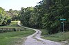
Fort Riverview (44AH91 and 44AH195)
November 16, 1989 (#89001921 ) Hilltop above the James River [6] 37°23′45″N 79°03′55″W / 37.395833°N 79.065278°W / 37.395833; -79.065278 (Fort Riverview (44AH91 and 44AH195) ) Madison Heights
16
Galt's Mill Complex
September 30, 2009 (#09000791 ) 1133 Galt's Mill Rd. 37°26′49″N 79°00′39″W / 37.446944°N 79.010833°W / 37.446944; -79.010833 (Galt's Mill Complex ) Madison Heights
17
Geddes
February 24, 1983 (#83003257 ) Jefferson Trace 37°40′01″N 78°59′14″W / 37.666944°N 78.987222°W / 37.666944; -78.987222 (Geddes ) Clifford
18
The Glebe
May 15, 2008 (#08000419 ) 156 State Route 151 37°37′23″N 79°00′50″W / 37.623056°N 79.013899°W / 37.623056; -79.013899 (The Glebe ) Amherst
19
Hanshill
September 29, 2011 (#11000715 ) 142 Leftwich Rd. 37°28′18″N 79°09′15″W / 37.471667°N 79.154167°W / 37.471667; -79.154167 (Hanshill ) Madison Heights
20
Hite Store
June 6, 1997 (#97000487 ) 0.25 miles (0.40 km) south of the junction of Woodson and Lowesville Rds. 37°43′06″N 79°04′01″W / 37.718472°N 79.066944°W / 37.718472; -79.066944 (Hite Store ) Lowesville
21
Kenmore Farm
February 17, 2015 (#15000012 ) 369 Kenmore Rd. 37°35′08″N 79°04′12″W / 37.585556°N 79.070000°W / 37.585556; -79.070000 (Kenmore Farm ) Amherst
22
Macedonia Methodist Church
February 8, 2012 (#12000017 ) 1408 Coffeytown Rd. 37°46′20″N 79°13′39″W / 37.772361°N 79.227500°W / 37.772361; -79.227500 (Macedonia Methodist Church ) Vesuvius
23
April 2, 2019 (#100003601 ) 123 Phelps Rd. 37°25′52″N 79°07′21″W / 37.431111°N 79.122500°W / 37.431111; -79.122500 (Madison Heights Elementary School ) Madison Heights
24
Mountain View Farm
September 3, 1997 (#96001453 ) 2229 N. U.S. Route 29 37°38′29″N 78°59′08″W / 37.641389°N 78.985556°W / 37.641389; -78.985556 (Mountain View Farm ) Clifford
25
Norfolk Southern Six Mile Bridge No. 58
October 12, 1995 (#95001175 ) Over the James River west of the junction of Mt. Athos Rd. and the Norfolk Southern Railroad tracks 37°23′35″N 79°03′46″W / 37.393056°N 79.062778°W / 37.393056; -79.062778 (Norfolk Southern Six Mile Bridge No. 58 ) Lynchburg
26
Oak Lawn
September 6, 2006 (#06000802 ) 155 Winridge Dr. 37°29′03″N 79°08′59″W / 37.484167°N 79.149722°W / 37.484167; -79.149722 (Oak Lawn ) Madison Heights
27
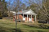
Upload image November 16, 2021 (#100007185 ) 156 Parrtown Rd. 37°40′47″N 79°04′34″W / 37.6797°N 79.0760°W / 37.6797; -79.0760 (Royster C. Parr House ) Amherst vicinity
28
Red Hill Farm
June 9, 1980 (#80004168 ) West of Pedlar Mills on Minors Branch Rd. 37°33′28″N 79°15′53″W / 37.557778°N 79.264722°W / 37.557778; -79.264722 (Red Hill Farm )
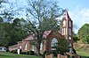
29
November 24, 2017 (#100001849 ) 3788 Buffalo Springs Turnpike 37°33′32″N 79°15′17″W / 37.558889°N 79.254722°W / 37.558889; -79.254722 (St. Luke's Episcopal Church )
30
Speed the Plough
April 30, 2007 (#07000391 ) 389 Fair Lea Ln. 37°32′00″N 79°11′28″W / 37.533333°N 79.191250°W / 37.533333; -79.191250 (Speed the Plough ) Monroe
31
Sweet Briar College Historic District
March 30, 1995 (#95000240 ) Sweet Briar Dr., 0.5 miles west of U.S. Route 29 37°33′14″N 79°04′48″W / 37.553889°N 79.08°W / 37.553889; -79.08 (Sweet Briar College Historic District ) Sweet Briar
32
Sweet Briar House
September 15, 1970 (#70000783 ) Southwest of the junction of U.S. Route 29 and Sweet Briar Rd. 37°33′27″N 79°04′58″W / 37.557500°N 79.082778°W / 37.557500; -79.082778 (Sweet Briar House ) Sweet Briar
33
March 5, 2019 (#100003484 ) 138-140 Union Hill Rd. 37°34′36″N 79°02′55″W / 37.576667°N 79.048611°W / 37.576667; -79.048611 (Thompson's Mill-Amherst Mill Complex ) Amherst
34
Tusculum
November 19, 2004 (#04001244 ) 2077 N. U.S. Route 29 37°38′10″N 78°59′51″W / 37.636111°N 78.997500°W / 37.636111; -78.997500 (Tusculum ) Amherst
35
Winton
May 2, 1974 (#74002104 ) West of State Route 151 37°38′17″N 79°01′27″W / 37.638056°N 79.0241667°W / 37.638056; -79.0241667 (Winton ) Clifford