National Register of Historic Places listings in Pittsylvania County, Virginia

Location of Pittsylvania County in Virginia
This is a list of the National Register of Historic Places listings in Pittsylvania County, Virginia.
This is intended to be a complete list of the properties and districts on the National Register of Historic Places in Pittsylvania County, Virginia, United States. The locations of National Register properties and districts for which the latitude and longitude coordinates are included below, may be seen in an online map.[1]
There are 21 properties and districts listed on the National Register in the county, including 1 National Historic Landmark. Another 2 properties were once listed but have been removed.
- This National Park Service list is complete through NPS recent listings posted February 11, 2022.[2]
Current listings[]


Former listings[]
| [3] | Name on the Register | Image | Date listed | Date removed | Location | City or town | Description |
|---|---|---|---|---|---|---|---|
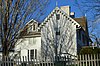
| 1 | Oak Hill |  |
December 28, 1979 (#79003068) | March 19, 2001 | VA 863 | Oak Ridge | Destroyed by fire in 1988 |
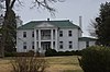
| 2 | Woodlawn |  |
May 26, 2005 (#05000478) | February 21, 2017 | 5321 Henrys Mill Rd. 36°46′31″N 79°09′48″W / 36.775278°N 79.163333°W | Vernon Hill |
See also[]
| Wikimedia Commons has media related to National Register of Historic Places in Pittsylvania County, Virginia. |
- List of National Historic Landmarks in Virginia
- National Register of Historic Places listings in Virginia
References[]
- ^ The latitude and longitude information provided in this table was derived originally from the National Register Information System, which has been found to be fairly accurate for about 99% of listings. Some locations in this table may have been corrected to current GPS standards.
- ^ National Park Service, United States Department of the Interior, "National Register of Historic Places: Weekly List Actions", retrieved February 11, 2022.
- ^ a b Numbers represent an alphabetical ordering by significant words. Various colorings, defined here, differentiate National Historic Landmarks and historic districts from other NRHP buildings, structures, sites or objects.
- ^ "National Register Information System". National Register of Historic Places. National Park Service. April 24, 2008.
- ^ The eight-digit number below each date is the number assigned to each location in the National Register Information System database, which can be viewed by clicking the number.
- ^ "Historical building burns". The News & Advance 2017-04-20: C1, C3: C1.
- ^ NPS
- ^ Virginia Historic Landmarks Commission Staff. National Register of Historic Places Inventory/Nomination: Windsor. National Park Service, 1980-04, 7.

Municipalities and communities of Pittsylvania County, Virginia, United States | ||
|---|---|---|
County seat: Chatham | ||
| Towns |
|  |
| CDPs |
| |
| Unincorporated communities |
| |
| ||
Categories:
- National Register of Historic Places in Pittsylvania County, Virginia
- Lists of National Register of Historic Places in Virginia by county