National Register of Historic Places listings in Falls Church, Virginia
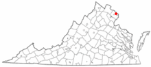
Location of Falls Church in Virginia
This is a list of the National Register of Historic Places listings in Falls Church, Virginia.
This is intended to be a complete list of the properties and districts on the National Register of Historic Places in the independent city of Falls Church, Virginia, United States. The locations of National Register properties and districts for which the latitude and longitude coordinates are included below, may be seen in a Google map.[1]
There are 6 properties and districts listed on the National Register in the city, including 1 National Historic Landmark.
- This National Park Service list is complete through NPS recent listings posted February 11, 2022.[2]
Current listings[]
| [3] | Name on the Register[4] | Image | Date listed[5] | Location | Description |
|---|---|---|---|---|---|
| 1 | Benjamin Banneker: SW-9 Intermediate Boundary Stone |  |
May 11, 1976 (#76002094) |
18th and Van Buren Sts. 38°52′59″N 77°09′33″W / 38.882944°N 77.159083°W |
Extends into Arlington County |
| 2 | Birch House |  |
October 26, 1977 (#77001534) |
312 E. Broad St. 38°52′45″N 77°10′01″W / 38.879036°N 77.167083°W |
|
| 3 | Cherry Hill |  |
July 26, 1973 (#73002210) |
312 Park Ave. 38°53′09″N 77°10′24″W / 38.885833°N 77.173472°W |
|
| 4 | Falls Church |  |
February 26, 1970 (#70000870) |
115 E. Fairfax St. 38°52′51″N 77°10′17″W / 38.880972°N 77.171389°W |
|
| 5 | Mount Hope | 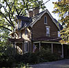 |
October 4, 1984 (#84000037) |
203 Oak St. 38°53′10″N 77°10′54″W / 38.886111°N 77.181667°W |
A brick, Victorian farmhouse built in 1870 by Irish immigrant William Duncan. The home is attached to an earlier structure, built around 1830.[6] |
| 6 | West Cornerstone | 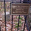 |
February 1, 1991 (#91000014) |
West side of Meridian St., south of the junction with Williamsburg Boulevard 38°53′36″N 77°10′20″W / 38.893333°N 77.172222°W |

See also[]
| Wikimedia Commons has media related to National Register of Historic Places in Falls Church, Virginia. |
- List of National Historic Landmarks in Virginia
- National Register of Historic Places listings in Virginia
References[]
- ^ The latitude and longitude information provided in this table was derived originally from the National Register Information System, which has been found to be fairly accurate for about 99% of listings. Some locations in this table may have been corrected to current GPS standards.
- ^ National Park Service, United States Department of the Interior, "National Register of Historic Places: Weekly List Actions", retrieved February 11, 2022.
- ^ Numbers represent an alphabetical ordering by significant words. Various colorings, defined here, differentiate National Historic Landmarks and historic districts from other NRHP buildings, structures, sites or objects.
- ^ "National Register Information System". National Register of Historic Places. National Park Service. April 24, 2008.
- ^ The eight-digit number below each date is the number assigned to each location in the National Register Information System database, which can be viewed by clicking the number.
- ^ McKeon, Nancy (May 22, 2010). "Falls Church house is Victorian through and through". The Washington Post. p. E01. Retrieved May 30, 2010.

Categories:
- National Register of Historic Places in Falls Church, Virginia
- Lists of National Register of Historic Places in Virginia by city