[3] Name on the Register[4]
Image
Date listed[5]
Location
Description
1
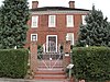
Briarwood
August 22, 2012 (#12000547 ) 1500 Southwick Rd. 36°51′39″N 76°00′50″W / 36.860833°N 76.013889°W / 36.860833; -76.013889 (Briarwood )
2
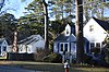
Camp Pendleton-State Military Reservation Historic District
September 26, 2005 (#04000852 ) Roughly bounded by General Booth Boulevard, S. Birdneck Rd., and the Atlantic Ocean 36°48′44″N 75°59′06″W / 36.812222°N 75.985000°W / 36.812222; -75.985000 (Camp Pendleton-State Military Reservation Historic District )
3
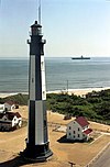
Cape Henry (Second Tower) Light Station
December 2, 2002 (#02001439 ) Atlantic Ave. 36°55′35″N 76°00′26″W / 36.926389°N 76.007222°W / 36.926389; -76.007222 (Cape Henry (Second Tower) Light Station )
4
Cape Henry Lighthouse
October 15, 1966 (#66000910 ) Atlantic Ave. at U.S. Route 60 36°55′33″N 76°00′29″W / 36.925833°N 76.008056°W / 36.925833; -76.008056 (Cape Henry Lighthouse )
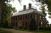
5
Cavalier Hotel
May 19, 2014 (#14000239 ) 4200 Pacific Ave. 36°52′09″N 75°59′01��W / 36.869167°N 75.983611°W / 36.869167; -75.983611 (Cavalier Hotel )
6
April 2, 2019 (#100003606 ) Generally bounded by 42nd St./Cavalier Dr., Hollies Rd., 45th St., and the Atlantic Ocean 36°52′20″N 75°59′02″W / 36.872222°N 75.983889°W / 36.872222; -75.983889 (Cavalier Shores Historic District )
7
de Witt Cottage
June 16, 1988 (#88000748 ) 1106 Atlantic Ave. 36°50′26″N 75°58′21″W / 36.840556°N 75.972500°W / 36.840556; -75.972500 (de Witt Cottage )
8
Ferry Plantation House
January 20, 2005 (#04001545 ) 4136 Cheswick Ln. 36°51′43″N 76°07′05″W / 36.861944°N 76.118056°W / 36.861944; -76.118056 (Ferry Plantation House )
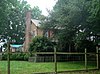
9
Green Hill
February 5, 2013 (#12001273 ) 1721 Lovetts Pond Lane 36°53′58″N 76°03′17″W / 36.899306°N 76.054722°W / 36.899306; -76.054722 (Green Hill )
10
The Hermitage
February 14, 2008 (#08000079 ) 4200 Hermitage 36°53′20″N 76°07′13″W / 36.888889°N 76.120278°W / 36.888889; -76.120278 (The Hermitage )
11
Upload image May 12, 2021 (#100006519 ) 3300 Pacific Ave. 36°51′41″N 75°58′48″W / 36.8613°N 75.9801°W / 36.8613; -75.9801 (Jefferson Manor Motel Apartments )
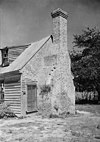
12
Keeling House
June 19, 1973 (#73002297 ) 3157 Adam Keeling Rd. 36°54′02″N 76°04′45″W / 36.900556°N 76.079167°W / 36.900556; -76.079167 (Keeling House )
13
Francis Land House
May 12, 1975 (#75002118 ) 3133 Virginia Beach Boulevard 36°50′32″N 76°04′46″W / 36.842222°N 76.079444°W / 36.842222; -76.079444 (Francis Land House )
14
Dr. John Miller-Masury House
May 23, 1997 (#97000488 ) 515 Wilder Point 36°52′42″N 75°59′31″W / 36.878333°N 75.991944°W / 36.878333; -75.991944 (Dr. John Miller-Masury House )
15
Thomas Murray House
May 19, 2004 (#04000482 ) 3425 S. Crestline Dr. 36°49′33″N 76°12′49″W / 36.825972°N 76.213611°W / 36.825972; -76.213611 (Thomas Murray House )
16
Oceana Neighborhood Historic District
September 18, 2017 (#100001645 ) Indiana, Louisa, Michigan, New York, and Ohio Aves., Middle, Roselynn, and West Lns., Oceana, Southern, and Virginia Beach Boulevards 36°50′28″N 76°00′54″W / 36.841111°N 76.015000°W / 36.841111; -76.015000 (Oceana Neighborhood Historic District )
17
Old Donation Church
April 13, 1972 (#72001534 ) 4449 N. Witch Duck Rd. 36°52′01″N 76°07′44″W / 36.866944°N 76.128889°W / 36.866944; -76.128889 (Old Donation Church )
18
Pembroke Manor
February 26, 1970 (#70000887 ) North of the junction of U.S. Route 58 and Constitution Dr. 36°51′08″N 76°08′02″W / 36.852222°N 76.133889°W / 36.852222; -76.133889 (Pembroke Manor )
19
Pleasant Hall
January 25, 1973 (#73002229 ) 5184 Princess Anne Rd. 36°49′40″N 76°09′44″W / 36.827778°N 76.162222°W / 36.827778; -76.162222 (Pleasant Hall )
20
Seashore State Park Historic District
November 16, 2005 (#05001267 ) 2500 Shore Dr. 36°54′58″N 76°02′26″W / 36.916111°N 76.040556°W / 36.916111; -76.040556 (Seashore State Park Historic District ) Now known as First Landing State Park
21
Shirley Hall
February 5, 1999 (#99000144 ) 1109 S. Bay Shore Dr. 36°52′25″N 76°00′27″W / 36.873611°N 76.007500°W / 36.873611; -76.007500 (Shirley Hall )
22
Thoroughgood House
October 15, 1966 (#66000921 ) 1636 Parish Rd. 36°53′37″N 76°06′48″W / 36.893611°N 76.113333°W / 36.893611; -76.113333 (Thoroughgood House )
23
Virginia Beach Surf & Rescue Museum
July 11, 1979 (#79003304 ) Atlantic Ave. and 24th St. 36°51′08″N 75°58′32″W / 36.852222°N 75.975556°W / 36.852222; -75.975556 (Virginia Beach Surf & Rescue Museum )
24
Upper Wolfsnare
March 26, 1975 (#75002119 ) East of the junction of Potters and London Bridge Rds. 36°50′27″N 76°02′20″W / 36.840833°N 76.038889°W / 36.840833; -76.038889 (Upper Wolfsnare )
25
June 4, 2018 (#100002196 ) Courthouse Dr. and Mattaponi, N. Landing, and Princess Anne Rds. 36°45′04″N 76°03′24″W / 36.751111°N 76.056667°W / 36.751111; -76.056667 (Virginia Beach Courthouse Village and Municipal Center Historic District )
26
Weblin House
November 8, 1974 (#74002248 ) 5588 Moore's Pond Rd. 36°52′31″N 76°09′59″W / 36.875278°N 76.166250°W / 36.875278; -76.166250 (Weblin House )
27
Wishart-Boush House
November 12, 1969 (#69000363 ) East of the junction of Wishart Rd. and Independence Boulevard 36°52′24″N 76°07′37″W / 36.873333°N 76.126944°W / 36.873333; -76.126944 (Wishart-Boush House )
28
Woodhouse House
April 24, 2007 (#07000372 ) 3067 W. Neck Rd. 36°43′41″N 76°03′11″W / 36.728056°N 76.053056°W / 36.728056; -76.053056 (Woodhouse House )