Location of Cherokee County in South Carolina
This is a list of the National Register of Historic Places listings in Cherokee County, South Carolina .
This is intended to be a complete list of the properties and districts on the National Register of Historic Places in Cherokee County , South Carolina , United States . The locations of National Register properties and districts for which the latitude and longitude coordinates are included below, may be seen in a map.[1]
There are 25 properties and districts listed on the National Register in the county. Another 4 properties and districts were once listed but have been removed.
This National Park Service list is complete through NPS recent listings posted February 11, 2022. [2]
Current listings [ ]
[3] Name on the Register[4]
Image
Date listed[5]
Location
City or town
Description
1
Archeological Site 38CK1 Upload image December 10, 1980 (#80003661 ) Address Restricted Gaffney
2
Archeological Site 38CK44 Upload image December 10, 1980 (#80003662 ) Address Restricted Gaffney
3
Archeological Site 38CK45 Upload image December 10, 1980 (#80003663 ) Address Restricted Gaffney
4
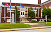
Carnegie Free Library
June 2, 2000 (#00000587 ) 210 N. Limestone St. 35°04′25″N 81°38′54″W / 35.073611°N 81.648333°W / 35.073611; -81.648333 (Carnegie Free Library ) Gaffney
5
Coopersville Ironworks Site (38CK2) and Susan Furnace Site (38CK67) Upload image November 13, 1976 (#76001699 ) Address Restricted Gaffney
6
Cowpens Furnace Site (38CK73)
May 8, 1987 (#87000704 ) Address Restricted Gaffney
7
Cowpens National Battlefield
October 15, 1966 (#66000072 ) 2 miles (3.2 km) east of Chesnee at the junction of South Carolina Highways 11 and 110 35°08′02″N 81°48′40″W / 35.133889°N 81.811111°W / 35.133889; -81.811111 (Cowpens National Battlefield ) Chesnee
8
Winnie Davis Hall
April 29, 1977 (#77001219 ) 1115 College Dr. 35°03′23″N 81°39′00″W / 35.056389°N 81.65°W / 35.056389; -81.65 (Winnie Davis Hall ) Gaffney
9
Ellen Furnace Site (38CK68) Upload image May 8, 1987 (#87000705 ) Address Restricted Gaffney
10
Gaffney Commercial Historic District
March 27, 1986 (#86000602 ) Roughly N. Limestone St. between Cherokee Ave. and E. Meadow St. 35°04′20″N 81°38′50″W / 35.072222°N 81.647222°W / 35.072222; -81.647222 (Gaffney Commercial Historic District ) Gaffney
11
Gaffney Residential Historic District
March 27, 1986 (#86000601 ) Roughly bounded by Floyd Baker Boulevard, Johnson and Thompson Sts., Rutledge and Fairview Aves., and Limestone St. 35°04′01″N 81°38′54″W / 35.066944°N 81.648333°W / 35.066944; -81.648333 (Gaffney Residential Historic District ) Gaffney
12
Zeno Hicks House
February 9, 1989 (#89000002 ) U.S. Route 221 and Mill Gap Rd.35°09′07″N 81°51′21″W / 35.151944°N 81.855833°W / 35.151944; -81.855833 (Zeno Hicks House ) Chesnee
13
Irene Mill Finishing Plant
March 27, 1986 (#86000591 ) Western side of Buford St. between Liberty and Logan Sts. 35°04′28″N 81°38′36″W / 35.074444°N 81.643333°W / 35.074444; -81.643333 (Irene Mill Finishing Plant ) Gaffney
14
Jefferies House
March 27, 1986 (#86000594 ) 306 S. Grannard St. 35°04′16″N 81°39′11″W / 35.071111°N 81.653056°W / 35.071111; -81.653056 (Jefferies House ) Gaffney
15
King's Creek Furnace Site (38CK71) Upload image May 8, 1987 (#87000707 ) Address Restricted
16
Kings Mountain National Military Park
October 15, 1966 (#66000079 ) Northwest of Bethany on South Carolina Highway 161 35°08′16″N 81°23′22″W / 35.137778°N 81.389444°W / 35.137778; -81.389444 (Kings Mountain National Military Park ) Bethany Extends into York County
17
Kings Mountain State Park Historic District
March 14, 2008 (#08000185 ) 1277 Park Rd. 35°07′50″N 81°20′44″W / 35.130579°N 81.345549°W / 35.130579; -81.345549 (Kings Mountain State Park Historic District ) Blacksburg
18
Limestone Springs Historic District
March 27, 1986 (#86000597 ) O'Neal St. extension and Limestone College campus 35°03′14″N 81°38′53″W / 35.053889°N 81.648056°W / 35.053889; -81.648056 (Limestone Springs Historic District ) Gaffney
19
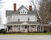
Magness-Humphries House
October 20, 2001 (#01001159 ) 101 Grassy Pond Rd. 35°08′08″N 81°40′26″W / 35.135556°N 81.673889°W / 35.135556; -81.673889 (Magness-Humphries House ) Gaffney
20
Mulberry Chapel Methodist Church
June 21, 2012 (#12000370 ) 582 Asbury Rd. 34°55′48″N 81°39′15″W / 34.93003333°N 81.65416667°W / 34.93003333; -81.65416667 (Mulberry Chapel Methodist Church ) Pacolet vicinity
21
Nesbitt's Limestone Quarry (38CK69) Upload image May 8, 1987 (#87000710 ) Address Restricted Gaffney
22
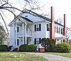
Nuckolls-Jefferies House
April 18, 2007 (#07000336 ) 571 Asbury Rd. 34°55′56″N 81°39′40″W / 34.932096°N 81.661089°W / 34.932096; -81.661089 (Nuckolls-Jefferies House ) Pacolet
23
Settlemyer House
March 27, 1986 (#86000598 ) 915 N. Limehouse St. 35°04′47″N 81°38′36″W / 35.079722°N 81.643333°W / 35.079722; -81.643333 (Settlemyer House ) Gaffney
24
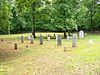
Shiloh Presbyterian Church Cemetery
December 22, 2011 (#11000954 ) Elm St., 0.9 miles (1.4 km) south of U.S. Route 29 35°10′09″N 81°25′57″W / 35.169297°N 81.432442°W / 35.169297; -81.432442 (Shiloh Presbyterian Church Cemetery ) Blacksburg Extends into Cleveland County, North Carolina
25
Thicketty Mountain Ore Pits (38CK74) Upload image May 8, 1987 (#87000711 ) Address Restricted
Former listings [ ]
[3] Name on the Register
Image
Date listed Date removed Location
City or town
Description
1
Upload image March 27, 1986 (#86000593) March 15, 2000 310 W. Buford St. Gaffney Demolished
2
Upload image March 27, 1986 (#86000599) March 15, 2000 217 Marion St. Gaffney Demolished.
3
Upload image March 27, 1986 (#86000596) March 15, 2000 West side of Frederick St. between Hill St. and Johnson St. Gaffney Demolished.
4
Upload image March 27, 1986 (#86000600) March 15, 2000 Floyd Baker Blvd. and Broad St. Gaffney Demolished.
See also [ ] References [ ]
^ The latitude and longitude information provided in this table was derived originally from the National Register Information System, which has been found to be fairly accurate for about 99% of listings. Some locations in this table may have been corrected to current GPS standards.
^ National Park Service, United States Department of the Interior , "National Register of Historic Places: Weekly List Actions" , retrieved February 11, 2022.
^ a b Numbers represent an alphabetical ordering by significant words. Various colorings, defined here , differentiate National Historic Landmarks and historic districts from other NRHP buildings, structures, sites or objects.
^ "National Register Information System" . National Register of Historic Places National Park Service . March 13, 2009.^ The eight-digit number below each date is the number assigned to each location in the National Register Information System database, which can be viewed by clicking the number.
Topics Lists Lists by city Other lists