National Register of Historic Places listings in Franklin County, Washington

Location of Franklin County in Washington
This list presents the full set of buildings, structures, objects, sites, or districts designated on the National Register of Historic Places in Franklin County, Washington, and offers brief descriptive information about each of them. The National Register recognizes places of national, state, or local historic significance across the United States.[1] Out of over 90,000 National Register sites nationwide,[2] Washington is home to approximately 1,500,[3] and 14 of those are found partially or wholly in Franklin County.
This National Park Service list is complete through NPS recent listings posted February 18, 2022.[4]
Current listings[]
| [5] | Name on the Register | Image | Date listed[6] | Location | City or town | Description |
|---|---|---|---|---|---|---|
| 1 | November 16, 1978 (#78002741) |
Address Restricted | Pasco | |||
| 2 | December 15, 1978 (#78002742) |
Address Restricted | ||||
| 3 | Franklin County Courthouse | 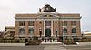 |
February 8, 1978 (#78002740) |
1016 N. 4th Ave.. 46°14′14″N 119°05′44″W / 46.237222°N 119.095556°W | Pasco | |
| 4 | Lower Snake River Archaeological District | October 29, 1984 (#84000471) |
Address Restricted | Pasco | ||
| 5 | Marmes Rockshelter | 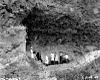 |
October 15, 1966 (#66000745) |
Under Lake Herbert G. West 46°36′52″N 118°12′09″W / 46.6144°N 118.2025°W | ||
| 6 |  |
May 31, 1979 (#79002532) |
Off U.S. 395 46°13′43″N 119°08′04″W / 46.228611°N 119.134444°W | Pasco | ||
| 7 | October 29, 1984 (#84000464) |
Address Restricted | Starbuck | |||
| 8 | 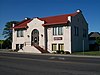 |
August 3, 1982 (#82004212) |
305 N. 4th Ave. 46°13′58″N 119°05′35″W / 46.232778°N 119.093056°W | Pasco | Carnegie Libraries of Washington TR | |
| 9 | Sacajawea State Park |  |
April 24, 2007 (#07000364) |
2503 Sacajawea Park Rd 46°12′00″N 119°02′26″W / 46.2°N 119.040556°W | Pasco | |
| 10 | Savage Island Archeological District | 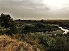 |
August 28, 1976 (#76001881) |
Address Restricted | Richland | |
| 11 | 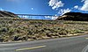 |
December 31, 2018 (#100003280) |
Milepost 270.0, former SP&S RR line 46°32′57″N 118°33′29″W / 46.5491°N 118.5581°W | vicinity | ||
| 12 | 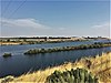 |
August 21, 1980 (#80003999) |
Address Restricted | Pasco | ||
| 13 | Tri-Cities Archaeological District |  |
October 29, 1984 (#84000468) |
Address Restricted | Richland | |
| 14 | Windust Caves Archaeological District |  |
October 29, 1984 (#84000479) |
Address Restricted |
Former listings[]
| [5] | Name on the Register | Image | Date listed | Date removed | Location | City or town | Description |
|---|---|---|---|---|---|---|---|
| 1 | Pasco-Kennewick Bridge | 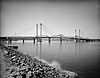 |
March 26, 1979 (#82004213) | July 16, 1990 | Spanned the Columbia River downstream of the Ed Hendler Bridge | Pasco |
See also[]
- National Register of Historic Places listings in Washington state
- Listings in neighboring counties: Adams, Benton, Columbia, Grant, Benton, Walla Walla, Whitman
- List of National Historic Landmarks in Washington (state)
- Historic preservation
- History of Washington (state)
- Index of Washington-related articles
References[]
- ^ Andrus, Patrick W.; Shrimpton, Rebecca H.; et al. (2002), How to Apply the National Register Criteria for Evaluation, National Register Bulletin, National Park Service, U.S. Department of the Interior, retrieved June 20, 2014.
- ^ National Park Service, National Register of Historic Places Program: Research, retrieved January 28, 2015.
- ^ Department of Archaeology and Historic Preservation, Washington Information System for Architectural and Archaeological Records Data (WISAARD), retrieved February 14, 2015.
- ^ National Park Service, United States Department of the Interior, "National Register of Historic Places: Weekly List Actions", retrieved February 18, 2022.
- ^ a b Numbers represent an alphabetical ordering by significant words. Various colorings, defined here, differentiate National Historic Landmarks and historic districts from other NRHP buildings, structures, sites or objects.
- ^ The eight-digit number below each date is the number assigned to each location in the National Register Information System database, which can be viewed by clicking the number.
External links[]
- Washington Department of Archaeology and Historic Preservation, Historic Register program
- National Park Service, National Register of Historic Places site
 Media related to National Register of Historic Places in Franklin County, Washington at Wikimedia Commons
| Lists by county |
|  |
|---|---|---|
| Other lists |
| |
| Topics | |
|---|---|
| Lists by state |
|
| Lists by insular areas | |
| Lists by associated state | |
| Other areas | |
| Related | |
| |
Municipalities and communities of Franklin County, Washington, United States | ||
|---|---|---|
| Cities |  | |
| CDPs | ||
| Unincorporated communities | ||
| Ghost towns | ||
| ||
Categories:
- Lists of National Register of Historic Places in Washington (state) by county
- National Register of Historic Places in Franklin County, Washington