National Register of Historic Places listings in Whatcom County, Washington

Location of Whatcom County in Washington
This is a list of the National Register of Historic Places listings in Whatcom County, Washington.
This is intended to be a complete list of the properties and districts on the National Register of Historic Places in Whatcom County, Washington, United States. Latitude and longitude coordinates are provided for many National Register properties and districts; these locations may be seen together in a map.[1]
There are 74 properties and districts listed on the National Register in the county. Another property was once listed but has been removed.
This National Park Service list is complete through NPS recent listings posted March 11, 2022.[2]
Current listings[]
| [3] | Name on the Register[4] | Image | Date listed[5] | Location | City or town | Description |
|---|---|---|---|---|---|---|
| 1 | Aftermath Clubhouse |  |
December 14, 1978 (#78002785) |
1300 Broadway 48°45′28″N 122°29′24″W / 48.757778°N 122.49°W | Bellingham | Some guess Aftermath Clubhouse to be the first women's clubhouse built in Washington.[6] |
| 2 |  |
December 21, 1990 (#90001866) |
Southeast of Bagley Lakes, Mt. Baker-Snoqualmie NF 48°51′18″N 121°40′59″W / 48.855°N 121.683056°W | Glacier | ||
| 3 |  |
March 7, 2012 (#12000087) |
413 E. Maple St. 48°44′44″N 122°28′41″W / 48.745493°N 122.478143°W | Bellingham | ||
| 4 | B. P. O. E. Building | 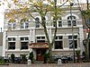 |
March 26, 1992 (#92000282) |
1412-1414 Cornwall Ave. 48°45′05″N 122°28′31″W / 48.751389°N 122.475278°W | Bellingham | Also known as the Elk's Club. |
| 5 |  |
November 21, 1974 (#74001989) |
2001 Eldridge Ave. 48°45′33″N 122°29′43″W / 48.759167°N 122.495278°W | Bellingham | Built by Henry Bacon, first cousin of George. | |
| 6 |  |
December 15, 2004 (#04001371) |
211 W. Holly St. 48°45′09″N 122°28′50″W / 48.7525°N 122.480556°W | Bellingham | The Barlow Building currently houses Goat Mountain Pizza. | |
| 7 | Beaver Pass Shelter |  |
February 10, 1989 (#88003448) |
Beaver Pass, 14 mi (23 km). west of Ross Lake 48°52′20″N 121°14′56″W / 48.872222°N 121.248889°W | Diablo | |
| 8 | 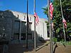 |
December 30, 2011 (#11000987) |
210 Lottie St. 48°45′20″N 122°28′44″W / 48.755517°N 122.478839°W | Bellingham | ||
| 9 | 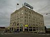 |
December 31, 2013 (#13001032) |
1155 N. State St. 48°44′51″N 122°28′45″W / 48.747440°N 122.479091°W | Bellingham | ||
| 10 | Bellingham National Bank Building |  |
October 13, 1983 (#83004275) |
101-111 E. Holly St. 48°45′00″N 122°28′38″W / 48.75°N 122.477222°W | Bellingham | |
| 11 |  |
April 22, 2003 (#03000306) |
8837 Bethusen Rd. 48°57′43″N 122°30′25″W / 48.961944°N 122.506944°W | Lynden | ||
| 12 |  |
December 4, 1980 (#80004012) |
158 S. Forest St. 48°44′07″N 122°29′38″W / 48.735278°N 122.493889°W | Bellingham | Also known as Wahl House. | |
| 13 | 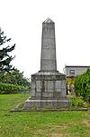 |
May 30, 1975 (#75001881) |
Marine Dr. at U.S./Canada border 49°00′08″N 123°05′17″W / 49.002222°N 123.088056°W | Point Roberts | ||
| 14 |  |
January 4, 2012 (#11001014) |
Roughly bounded by Illinois, W. North, Summer & Ellis Sts. 48°45′55″N 122°28′37″W / 48.765247°N 122.476847°W | Bellingham | ||
| 15 |  |
January 11, 2010 (#09001219) |
Area roughly bounded by H., Halleck, G., and Girard Sts.[7] 48°45′35″N 122°29′02″W / 48.759761°N 122.483789°W | Bellingham | ||
| 16 | Copper Mountain Fire Lookout |  |
February 10, 1989 (#88003446) |
On Copper Mountain, 10 mi (16 km). east of Hannegan Campground 48°54′33″N 121°27′41″W / 48.909167°N 121.461389°W | Newhalem | |
| 17 |  |
December 15, 2004 (#04001370) |
1201-1213 N. State St. 48°44′59″N 122°28′43″W / 48.749722°N 122.478611°W | Bellingham | ||
| 18 |  |
February 10, 1989 (#88003452) |
East of Ross Lake on Lightning Creek Trail, south of Three Fools Trail 48°54′00″N 120°58′46″W / 48.9°N 120.979444°W | |||
| 19 |  |
February 10, 1989 (#88003451) |
On Desolation Peak east of Ross Lake, 6 mi (9.7 km). south of Canada–US border 48°54′42″N 121°00′54″W / 48.911667°N 121.015°W | |||
| 20 | Devil's Corner Cliff Walk |  |
June 7, 1974 (#74000909) |
North of Newhalem in Ross Lake National Recreation Area 48°41′28″N 121°13′23″W / 48.691111°N 121.223056°W | Newhalem | |
| 21 | Diablo Hydroelectric Power Plant |  |
June 30, 1989 (#89000498) |
Off WA 20 at W end of Diablo Lake 48°42′52″N 121°08′04″W / 48.714444°N 121.134444°W | Newhalem | Consists of 520 acres (2.1 km2), 1 building, and 8 structures. |
| 22 | J. J. Donovan House |  |
January 27, 1983 (#83003356) |
1201 Garden St. 48°44′47″N 122°28′31″W / 48.746389°N 122.475278°W | Bellingham | Was used as a women's dormitory by Western Washington University for roughly 25 years. |
| 23 |  |
December 29, 2014 (#14001110) |
Roughly bounded by E. Maple, N. Forest, York, Prospect, Bay & W. Chestnut Sts., Central & Cornwall Aves. 48°45′43″N 122°29′48″W / 48.761944°N 122.496667°W | Bellingham | ||
| 24 |  |
July 27, 1979 (#79002566) |
Eldridge Ave. and environs 48°45′43″N 122°29′48″W / 48.761944°N 122.496667°W | Bellingham | Encompasses 1,500 acres (6.1 km2), 683 buildings, and 1 structure. | |
| 25 |  |
January 27, 1983 (#83003357) |
2915 Eldridge Ave. 48°45′46″N 122°30′29″W / 48.762778°N 122.508056°W | Bellingham | The home currently occupying the site, is the fourth, being built after three others burned. | |
| 26 | Fairhaven Historic District |  |
August 19, 1977 (#77001363) |
Roughly bounded by 10th and 13th Sts., Columbia and Larrabee Aves. 48°43′13″N 122°30′07″W / 48.720278°N 122.501944°W | Bellingham | Roughly bounded by 10th and 13th Sts., Columbia and Larrabee Aves., (85 acres, 16 buildings) |
| 27 |  |
August 3, 1982 (#82004907) |
1105 12th St. 48°43′17″N 122°30′05″W / 48.721389°N 122.501389°W | Bellingham | Carnegie Libraries of Washington TR | |
| 28 |  |
February 10, 1989 (#88003454) |
Hozomeen Lake-Lightning Creek trailhead on E side of Ross Lake 48°59′08���N 121°04′07″W / 48.985556°N 121.068611°W | |||
| 29 | Flatiron Building |  |
January 27, 1983 (#83003358) |
1311-1319 Bay St. 48°45′07″N 122°28′47″W / 48.751944°N 122.479722°W | Bellingham | Bellingham's first "Skyscraper". It was originally built for the Bellingham Bay (B.B.) Furniture Co. |
| 30 | Gamwell House |  |
March 16, 1972 (#72001282) |
1001 16th St. 48°43′26″N 122°29′44″W / 48.723889°N 122.495556°W | Bellingham | |
| 31 |  |
September 17, 1980 (#80004013) |
Mount Baker Hwy. 48°53′16″N 121°56′07″W / 48.887778°N 121.935278°W | Glacier | ||
| 32 |  |
June 30, 1989 (#89000499) |
Off WA 20 at W end of Gorge Lake 48°40′32″N 121°14′25″W / 48.675661°N 121.240274°W | Newhalem | 820 acres (3.3 km2), 1 building, and 6 structures | |
| 33 |  |
May 30, 1975 (#75001879) |
S end of D St. 48°45′14″N 122°29′07″W / 48.753889°N 122.485278°W | Bellingham | Building is currently utilized by Burlington Northern-Santa Fe. | |
| 34 |  |
August 29, 2003 (#01000477) |
1226 N. State St. 48°44′52″N 122°28′35″W / 48.747778°N 122.476389°W | Bellingham | Currently being remodeled. | |
| 35 | Hovander Homestead |  |
October 16, 1974 (#74001990) |
5299 Neilson Rd. 48°49′46″N 122°35′24″W / 48.829444°N 122.59°W | Ferndale | |
| 36 |  |
November 7, 2003 (#03001127) |
1303 Astor St. 48°53′10″N 122°39′39″W / 48.886111°N 122.660833°W | Bellingham | ||
| 37 | February 10, 1989 (#88003450) |
Along US-Canada border between eastern boundary of Ross Lake NRA and western boundary of North Cascades National Park 49°00′04″N 121°31′19″W / 49.001111°N 121.521944°W | ||||
| 38 |  |
June 10, 1991 (#91000708) |
Forest Rd. 11, west of Baker Lake, Mt. Baker National Forest 48°39′42″N 121°42′49″W / 48.661667°N 121.713611°W | Concrete | ||
| 39 | Larrabee House |  |
May 30, 1975 (#75001880) |
405 Fieldston Rd. 48°42′43″N 122°30′26″W / 48.711944°N 122.507222°W | Bellingham | Commissioned by Charles Xavier Larrabee, he did not live to see it built. Also known as Lairmont Manor and Mt. St. Mary's Novitiate. |
| 40 | Leopold Hotel | 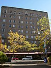 |
February 19, 1982 (#82004306) |
1224 Cornwall Ave. 48°44′57″N 122°28′43″W / 48.749167°N 122.478611°W | Bellingham | The Leopold Hotel currently houses a retirement home. |
| 41 |  |
July 20, 2011 (#11000476) |
444 Front St. 48°56′35″N 122°27′10″W / 48.943056°N 122.452778°W | Lynden | Also known as the Waples Building / Delft Square. Heavily damaged by fire in 2008. | |
| 42 | 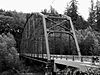 |
July 16, 1982 (#82004305) |
Mosquito Lake Rd. 48°47′05″N 122°06′40″W / 48.784722°N 122.111111°W | Acme | Historic Bridges and Tunnels in Washington TR | |
| 43 |  |
April 29, 1993 (#93000371) |
114 W. Magnolia St. 48°45′05″N 122°28′41″W / 48.751378°N 122.478075°W | Bellingham | Designed by John Graham Sr. | |
| 44 |  |
February 2, 2005 (#04001594) |
1023-1025 N. State St. 48°44′52″N 122°28′52″W / 48.747778°N 122.481111°W | Bellingham | ||
| 45 | 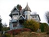 |
November 7, 1977 (#77001364) |
1014 N. Garden St. 48°44′41″N 122°28′38″W / 48.744722°N 122.477222°W | Bellingham | ||
| 46 | Mount Baker Theatre |  |
December 14, 1978 (#78002786) |
106 N. Commercial St. 48°45′08″N 122°28′36″W / 48.752222°N 122.476667°W | Bellingham | Designed by Robert Reamer, designer of the Old Faithful Inn. |
| 47 | MV Plover |  |
June 4, 1997 (#97000551) |
245 Marine Dr.;Blaine Harbor Berth A-11 48°59′37″N 122°45′31″W / 48.993611°N 122.758611°W | Blaine | |
| 48 | Nooksack Falls Hydroelectric Power Plant |  |
December 15, 1988 (#88002735) |
Rt. 542 on Nooksack River 48°54′33″N 121°49′31″W / 48.909167°N 121.825278°W | Glacier | |
| 49 |  |
March 25, 1999 (#99000403) |
310-318 W. Holly St. and 419 Champion St. 48°45′06″N 122°28′54″W / 48.7517°N 122.4817°W | Bellingham | The Oakland Block was recently remodeled to provide low-income housing. | |
| 50 |  |
November 7, 1977 (#77001365) |
516 High St. 48°44′17″N 122°28′58″W / 48.738056°N 122.482778°W | Bellingham | ||
| 51 |  |
July 21, 2015 (#15000456) |
901 N. Forest St. 48°44′37″N 122°28′56″W / 48.7436°N 122.4821°W | Bellingham | ||
| 52 | 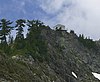 |
July 14, 1987 (#87001189) |
Mt. Baker Ranger District, southwest of the Easton Glacier of Mt. Baker 48°42′59″N 121°51′18″W / 48.716389°N 121.855°W | Sedro-Woolley vicinity | ||
| 53 | Peace Arch |  |
December 13, 1996 (#96001493) |
Peace Arch State Park, US 5 at the Canada–US border 48°59′59″N 122°45′10″W / 48.999722°N 122.752778°W | Blaine | |
| 54 | Perry Creek Shelter | 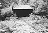 |
February 10, 1989 (#88003447) |
On Little Beaver Trail, 5 mi (8.0 km). west of Ross Lake 48°55′16″N 121°09′21″W / 48.921111°N 121.155833°W | ||
| 55 | Pickett House | 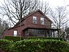 |
December 13, 1971 (#71000881) |
910 Bancroft St. 48°45′23″N 122°29′04″W / 48.756389°N 122.484444°W | Bellingham | The former home of George Pickett is the oldest building in Bellingham. |
| 56 | T. G. Richards and Company Store |  |
August 28, 2003 (#03000861) |
1308 E St. 48°45′17″N 122°29′10″W / 48.754786°N 122.486208°W | Bellingham | Later became the Washington Territorial Courthouse. The oldest brick building in Washington. |
| 57 |  |
November 7, 1977 (#77001366) |
2600 Sunset Dr. 48°45′56″N 122°28′41″W / 48.765556°N 122.478056°W | Bellingham | The home currently provides space for different educational activities. | |
| 58 | Lottie Roth Block |  |
December 12, 1978 (#78002787) |
1106 W. Holly St. 48°45′22��N 122°29′14″W / 48.756111°N 122.487222°W | Bellingham | |
| 59 | 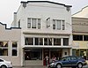 |
February 2, 2005 (#04001593) |
1015-1019 N. State St. 48°44′52″N 122°28′53″W / 48.747778°N 122.481389°W | Bellingham | The Sanitary Meat Market originally occupied 1015-1019 N. State St., now only 1017. | |
| 60 |  |
February 13, 2001 (#01000063) |
Portions of Jersey, Key, Liberty, Mason, Newell, E. Myrtle, E. Laurel, and E. Maple Sts. 48°44′23″N 122°28′32″W / 48.739608°N 122.475472°W | Bellingham | Includes portions of Jersey, Key, Liberty, Mason, Newell, E. Myrtle, E. Laurel, and E. Maple Streets, with 153 buildings. | |
| 61 |  |
June 30, 2000 (#00000697) |
Address Restricted | Blaine | ||
| 62 | Skagit River and Newhalem Creek Hydroelectric Projects | 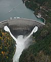 |
April 26, 1996 (#96000416) |
At Newhalem on the Skagit River and at Ross Dam 48°41′50″N 121°11′14″W / 48.697222°N 121.187222°W | Newhalem | 420 acres (1.7 km2), 21 buildings, 5 structures, and 1 object |
| 63 | Sourdough Mountain Lookout |  |
February 10, 1989 (#88003449) |
On Sourdough Mountain, 5 mi (8.0 km). northeast of Diablo 48°44′34″N 121°06′29″W / 48.742778°N 121.108056°W | Diablo | |
| 64 | 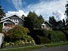 |
February 24, 2010 (#09001296) |
Bounded by Knox, 11th, State, Cedar, 17th, and Highland 48°43′42″N 122°29′52″W / 48.728372°N 122.497747°W | Bellingham | ||
| 65 | U.S. Post Office and Courthouse |  |
April 30, 1979 (#79003157) |
104 W. Magnolia St. 48°45′05″N 122°28′35″W / 48.751389°N 122.476389°W | Bellingham | Formerly the Bellingham Federal Building, the building is now owned by the city. |
| 66 | 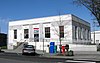 |
August 7, 1991 (#91000648) |
600 Front St. 48°56′34″N 122°27′13″W / 48.942778°N 122.453611°W | Lynden | ||
| 67 | 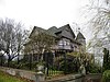 |
December 1, 1988 (#88002744) |
1103 15th St. 48°43′21″N 122°29′49″W / 48.7225°N 122.496944°W | Bellingham | Also known as Wardner Castle, James Wardner only lived in the home for one year. | |
| 68 |  |
December 13, 1996 (#96001494) |
1125 Railroad Ave. 48°44′54″N 122°29′33″W / 48.748333°N 122.4925°W | Bellingham | ||
| 69 | Whatcom Museum of History and Art |  |
April 3, 1970 (#70000648) |
121 Prospect St. 48°45′10″N 122°28′48″W / 48.752778°N 122.48°W | Bellingham | Formerly the Bellingham City Hall. |
| 70 | Wild Goose Pass Tree | June 7, 1991 (#91000706) |
Address Restricted | Glacier | ||
| 71 | Winchester Mountain Lookout |  |
July 14, 1987 (#87001188) |
Mt. Baker Wilderness Area overlooking the N fork of Nooksack River and W fork of Silesia Creek 48°57′25″N 121°38′31″W / 48.956944°N 121.641944°W | Sedro-Woolley vicinity | |
| 72 |  |
February 1, 2010 (#09001297) |
Bounded roughly by Ellis St., Meador Ave., I-5, and Lakeway Dr. 48°44′57″N 122°28′05″W / 48.7493°N 122.468033°W | Bellingham | ||
| 73 | August 10, 2021 (#100006806) |
1200 Chuckanut Dr. 48°41′52″N 122°29′45″W / 48.6979°N 122.4958°W | Bellingham | |||
| 74 | 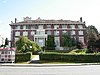 |
April 21, 1977 (#77001367) |
1026 N. Forest St. 48°44′44″N 122°28′41″W / 48.745556°N 122.478056°W | Bellingham |
Former listings[]
| [3] | Name on the Register | Image | Date listed | Date removed | Location | City or town | Description |
|---|---|---|---|---|---|---|---|
| 1 |  |
May 14, 1981 (#81000594) | November 22, 2000 | 1201 Roeder Ave. | Bellingham | Collapsed during a storm in 1986.[8] | |
| 2 |  |
1973 (#73002272) | January 1974 | SR 20 | Newhalem | Listed in 1973 without approval by the Washington State Review Board. They determined it was ineligible for listing, and requested removal. Now a contributing object of the Skagit River and Newhalen Creek Hydroelectric Projects historic district.[9] |
See also[]
- List of National Historic Landmarks in Washington
- National Register of Historic Places listings in Washington state
References[]
| Wikimedia Commons has media related to National Register of Historic Places in Whatcom County, Washington. |
- ^ The latitude and longitude information provided in this table was derived originally from the National Register Information System, which has been found to be fairly accurate for about 99% of listings. Some locations in this table may have been corrected to current GPS standards.
- ^ National Park Service, United States Department of the Interior, "National Register of Historic Places: Weekly List Actions", retrieved March 11, 2022.
- ^ a b Numbers represent an alphabetical ordering by significant words. Various colorings, defined here, differentiate National Historic Landmarks and historic districts from other NRHP buildings, structures, sites or objects.
- ^ "National Register Information System". National Register of Historic Places. National Park Service. April 24, 2008.
- ^ The eight-digit number below each date is the number assigned to each location in the National Register Information System database, which can be viewed by clicking the number.
- ^ Aftermath Clubhouse (1904) 1412 West Holly Street - City of Belligham, WA[permanent dead link]
- ^ Coordinates given are for the intersection of H Street and Girard Street, as resulting from a corresponding search in Google Earth.
- ^ "Citizens Dock was city's principal transit hub | BBJ Today". 31 October 2006.
- ^ NRHP listing 96000416
| Lists by county |
|  |
|---|---|---|
| Other lists |
| |
| Topics | |
|---|---|
| Lists by state |
|
| Lists by insular areas | |
| Lists by associated state | |
| Other areas | |
| Related | |
| |
Municipalities and communities of Whatcom County, Washington, United States | ||
|---|---|---|
| Cities |  | |
| CDPs | ||
| Indian reservations |
| |
| Unincorporated communities |
| |
| Ghost towns | ||
| ||
Categories:
- Lists of National Register of Historic Places in Washington (state) by county
- History of Bellingham, Washington
- National Register of Historic Places in Whatcom County, Washington