National Register of Historic Places listings in Pierce County, Washington

Location of Pierce County in Washington
This is intended to be a complete list of the properties and districts on the National Register of Historic Places in Pierce County, Washington, United States. Latitude and longitude coordinates are provided for many National Register properties and districts; these locations may be seen together in an online map.[1]
There are 192 properties and districts listed on the National Register in the county. 96 of these properties and districts are located in the city of Tacoma, while the remaining 96 properties and districts are listed separately. Another 2 properties were once listed but have been removed.
- This National Park Service list is complete through NPS recent listings posted September 3, 2021.[2]
Pierce County (exclusive of Tacoma)[]
| [3] | Name on the Register[4] | Image | Date listed[5] | Location | City or town | Description |
|---|---|---|---|---|---|---|
| 1 |  |
July 15, 1987 (#87001171) |
9512 Orting Hwy., E. 47°10′12″N 122°13′43″W / 47.170036°N 122.228619°W | Alderton | Rural Public Schools of Washington State MPS | |
| 2 |  |
July 15, 1987 (#87001165) |
Eckenstam-Johnson Rd. 47°09′32″N 122°42′14″W / 47.159022°N 122.703833°W | Anderson Island | Built in 1904, this is the oldest one-room schoolhouse in Pierce County.[6] Rural Public Schools of Washington State MPS | |
| 3 |  |
September 28, 1987 (#87001163) |
3507 Ray Nash Drive NW 47°17′23″N 122°39′44″W / 47.289747°N 122.662242°W | Gig Harbor | This former school was built by the Works Progress Administration in 1938, and is now used as a community center.[7] Rural Public Schools of Washington State MPS | |
| 4 | Ashford Mansion |  |
August 30, 1984 (#84003560) |
Off I-5 46°45′36″N 122°01′26″W / 46.760103°N 122.023797°W | Ashford | Built by Walter and Cora Ashford in a Colonial-Revival style.[8] |
| 5 |  |
February 19, 1982 (#82004276) |
Washington and Emery Streets 47°08′23″N 122°05′50″W / 47.139831°N 122.097181°W | South Prairie | ||
| 6 |  |
February 19, 1982 (#82004277) |
6000 112th St., SW 47°09′21″N 122°31′03″W / 47.15580°N 122.51753°W | Lakewood | The oldest surviving home in Lakewood.[9] | |
| 7 | Camp Muir |  |
March 13, 1991 (#91000176) |
Paradise 46°50′07″N 121°43′58″W / 46.835278°N 121.732778°W | Mount Rainier National Park | Also known as Cloud Camp, is on the southeast slope of the mountain, at 10,062 feet (3,067 m). Named for John Muir.[10] |
| 8 | Chinook Pass Entrance Arch |  |
March 13, 1991 (#91000202) |
Chinook Pass 46°52′20″N 121°30′52″W / 46.872331°N 121.514467°W | Mount Rainier National Park | |
| 9 | Christ Episcopal Church |  |
December 15, 1994 (#94001440) |
210 Fifth St. SW. 47°11′27″N 122°17′53″W / 47.190864°N 122.29795°W | Puyallup | Built in 1927 to replace a smaller church.[11] |
| 10 | Christine Falls Bridge |  |
March 13, 1991 (#91000196) |
Paradise 46°46′51″N 121°46′47″W / 46.780833°N 121.779722°W | Mount Rainier National Park | |
| 11 |  |
June 10, 1974 (#74001976) |
Southeast of Wilkeson at RR tracks 47°06′09″N 122°02′21″W / 47.102372°N 122.039039°W | Wilkeson | These 12-foot (4 m) tall ovens began being built in 1885 for cooking coal into coke.[12] Of the original 160 ovens, 40 still remain.[13] | |
| 12 |  |
March 7, 2012 (#12000088) |
4009 Curran Ln. 47°13′18″N 122°33′43″W / 47.221667°N 122.561978°W | University Place | ||
| 13 |  |
July 15, 1987 (#87001162) |
7700 Steilacoom Blvd. SW 47°10′52″N 122°32′17″W / 47.18115°N 122.537947°W | Lakewood | Also known as the "Little Red Schoolhouse" Rural Public Schools of Washington State MPS | |
| 14 |  |
March 31, 1995 (#95000305) |
1814 A St., Key Peninsula N 47°16′28″N 122°45′33″W / 47.274333°N 122.759247°W | Home | ||
| 15 |  |
March 27, 1973 (#73001884) |
1802 Commercial Street 47°10′27″N 122°35′47″W / 47.174083°N 122.596467°W | Steilacoom | Also known as the Philip Keach House. | |
| 16 | 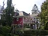 |
May 6, 1993 (#93000369) |
308 E. 133rd Street 47°08′11″N 122°25′41″W / 47.13638°N 122.42796°W | Parkland | ||
| 17 |  |
April 14, 1997 (#97000324) |
1808 E. Valley Hwy. 47°14′28″N 122°13′33″W / 47.241017°N 122.225739°W | Sumner | This Georgian Revival style building served as a school until 1992, when it turned into a corporate office.[14] Rural Public Schools of Washington State MPS | |
| 18 | DuPont Village Historic District |  |
September 10, 1987 (#87001542) |
Roughly bounded by Santa Cruz, Brandywine, DuPont, and Penniman 47°05′49″N 122°37′50″W / 47.096904°N 122.630578°W | Dupont | |
| 19 | Edith Creek Chlorination House |  |
March 13, 1991 (#91000201) |
Paradise 46°47′38″N 121°43′54″W / 46.793953°N 121.731644°W | Mount Rainier National Park | |
| 20 | Elbe Evangelical Lutheran Church |  |
October 8, 1976 (#76001899) |
I-5 46°45′52″N 122°11′39″W / 46.764581°N 122.194289°W | Elbe | The land and lumber to build the church were donated by German immigrants Henry and Clara Lutken. The main building of the church is 24 feet (7.3 m) by 18 feet (5.5 m), but the steeple rises 55 feet (17 m), and is topped with an iron cross.[15] |
| 21 | Ezra Meeker Mansion |  |
August 26, 1971 (#71000879) |
321 Pioneer Ave., E. 47°11′29″N 122°17′23″W / 47.191397°N 122.289692°W | Puyallup | Built in 1875, this 17-room house was the home of Oregon Trail migrant Ezra Meeker.[16] |
| 22 | Fairfax Bridge |  |
July 16, 1982 (#82004273) |
Spans Carbon River, south of Wilkeson 47°02′31″N 122°02′28″W / 47.041944°N 122.041111°W | Melmont | This bridge's deck sits 250 feet (76 m) above the Carbon River, which made it the tallest structure in Washington at the time it was built.[17] Historic Bridges and Tunnels in Washington TR |
| 23 | Fort Nisqually Site |  |
October 16, 1974 (#74001971) |
Northwest of Dupont off I-5 47°06′33″N 122°39′45″W / 47.109058°N 122.662594°W | Dupont | The first European trading post on Puget Sound, established in 1833, the Granary and Factor's house were moved to Point Defiance Park in the 1930s.[18] |
| 24 | Fort Steilacoom |  |
November 25, 1977 (#77001350) |
Northeast of Steilacoom 47°10′48″N 122°33′58″W / 47.18°N 122.566111°W | Steilacoom | Only operating as a fort from 1849 to 1868, the fort was then turned into the Western State Hospital. Today four officer's quarters built around 1858 remain from the original fort.[19] |
| 25 | Fox Island School |  |
July 15, 1987 (#87001167) |
Gway Drive and Ninth Street 47°15′15″N 122°37′13″W / 47.254161°N 122.620308°W | Fox Island | This former school was built in 1934 by the Works Progress Administration, and has served as a community center since 1961, when the island began busing its students to nearby Gig Harbor.[20] Rural Public Schools of Washington State MPS |
| 26 |  |
March 19, 1982 (#82004271) |
140 Oak St., E. 46°51′51″N 122°15′48″W / 46.864217°N 122.263383°W | Eatonville | Also known as Mill House and Eatonville Lumber Company House. | |
| 27 | Glencove Hotel |  |
May 22, 1978 (#78002767) |
West of Gig Harbor off SR 302. 47°20′49″N 122°43′49″W / 47.346886°N 122.730322°W | Gig Harbor | Built in 1897, the building still serves as a hotel.[21] |
| 28 | Gobbler's Knob Fire Lookout |  |
March 13, 1991 (#91000191) |
Nisqually Entrance 46°47′39″N 121°54′48″W / 46.794294°N 121.913375°W | Mount Rainier National Park | |
| 29 |  |
August 15, 2007 (#07000833) |
33514 Mount Tahoma Canyon Rd. 46°45′40″N 121°59′24″W / 46.761111°N 121.99°W | Ashford | A cabin built in 1888 in the Upper Nisqually Valley.[22] | |
| 30 | Holy Trinity Orthodox Church |  |
September 28, 1989 (#89001606) |
433 Long Street 47°06′27″N 122°02′42″W / 47.107461°N 122.044944°W | Wilkeson | Built in 1913, this church features a Russian-style onion dome.[13] |
| 31 |  |
April 12, 1982 (#82004272) |
6th and C Streets 47°16′30″N 122°45′51″W / 47.274883°N 122.764136°W | Home | ||
| 32 | Huckleberry Creek Patrol Cabin | March 13, 1991 (#91000178) |
Sunrise 46°59′41″N 121°37′03″W / 46.994842°N 121.617606°W | Mount Rainier National Park | ||
| 33 | Indian Bar Trail Shelter |  |
March 13, 1991 (#91000179) |
Paradise 46°49′33″N 121°38′19″W / 46.825819°N 121.638594°W | Mount Rainier National Park | |
| 34 | Indian Henry's Patrol Cabin |  |
March 13, 1991 (#91000180) |
Longmire 46°47′39″N 121°50′20″W / 46.794192°N 121.838953°W | Mount Rainier National Park | The structure was stabilized in 1978 with 300 lb (140 kg). footings.[23] |
| 35 | Ipsut Creek Patrol Cabin |  |
March 13, 1991 (#91000181) |
46°58′40″N 121°49′54″W / 46.977881°N 121.831694°W | Mount Rainier National Park | |
| 36 | Lake George Patrol Cabin |  |
March 13, 1991 (#91000182) |
Longmire 46°47′36″N 121°54′07″W / 46.793372°N 121.901864°W | Mount Rainier National Park | |
| 37 |  |
December 16, 2014 (#14001055) |
12317 Gravelly Lake Dr. 47°08′45″N 122°32′19″W / 47.1458°N 122.5386°W | Lakewood | ||
| 38 | 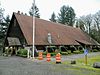 |
September 28, 1987 (#87001164) |
Gig Harbor-Longbranch Road 47°13′05″N 122°45′34″W / 47.218056°N 122.759444°W | Lakebay | Rural Public Schools of Washington State MPS | |
| 39 | Longmire Buildings |  |
May 28, 1987 (#87001338) |
Longmire 46°45′06″N 121°48′42″W / 46.751667°N 121.811667°W | Mount Rainier National Park | Extends into Lewis County |
| 40 | Longmire Historic District |  |
March 13, 1991 (#91000173) |
Longmire 46°44′59″N 121°48′45″W / 46.749722°N 121.8125°W | Mount Rainier National Park | Extends into Lewis County |
| 41 | 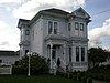 |
March 10, 1980 (#80004401) |
1004 2nd Ave., NW 47°11′34″N 122°18′22″W / 47.192669°N 122.306044°W | Puyallup | ||
| 42 | McMillin Bridge |  |
July 16, 1982 (#82004275) |
Spans Puyallup River on State Route 162 47°07′49″N 122°14′07″W / 47.130217°N 122.235261°W | McMillin | Also known as the Puyallup River Bridge, the bridge was thought to be the longest concrete truss in the country. Historic Bridges and Tunnels in Washington MPS |
| 43 |  |
July 15, 1987 (#87001172) |
State Route 162 47°08′29″N 122°14′05″W / 47.141283°N 122.234706°W | McMillin | This building served as the McMillin School from 1926 to 1963, and now serves as the McMillin Grange. Rural Public Schools of Washington State MPS | |
| 44 |  |
July 15, 1987 (#87001166) |
5115 Thirty-eighth Ave. NW 47°18′18″N 122°35′15″W / 47.305069°N 122.587533°W | Gig Harbor | This one-room building functioned as a schoolhouse from when it was built in 1893 until 1941.[21] Rural Public Schools of Washington State MPS | |
| 45 | Mt. Fremont Fire Lookout |  |
March 13, 1991 (#91000193) |
Sunrise 46°56′03″N 121°40′30″W / 46.934167°N 121.675°W | Mount Rainier National Park | |
| 46 | Mount Rainier National Park |  |
February 18, 1997 (#97000344) |
Longmire 46°52′59″N 121°53′04″W / 46.883056°N 121.884444°W | Mount Rainier National Park | The park is a National Historic Landmark District, which includes 165 contributing structures and buildings.[24] |
| 47 | Mowich Lake Patrol Cabin |  |
March 13, 1991 (#91000183) |
46°56′05″N 121°51′40″W / 46.9348°N 121.861142°W | Mount Rainier National Park | |
| 48 |  |
August 27, 2019 (#100004345) |
12711 Gravelly Lake Dr. SW 47°08′37″N 122°31′57″W / 47.1435°N 122.5326°W | Lakewood | ||
| 49 | Nisqually Entrance Historic District | 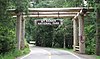 |
March 13, 1991 (#91000172) |
Nisqually Entrance 46°44′27″N 121°55′09″W / 46.740833°N 121.919167°W | Mount Rainier National Park | |
| 50 | North Mowich Trail Shelter | March 13, 1991 (#91000184) |
46°54′55″N 121°53′34″W / 46.915406°N 121.892808°W | Mount Rainier National Park | ||
| 51 |  |
January 27, 1984 (#84003570) |
Park Avenue, S. and Garfield Street 47°08′46″N 122°26′21″W / 47.146244°N 122.4392°W | Parkland | Now known as Harstad Hall | |
| 52 |  |
November 21, 1972 (#72001280) |
1807 Rainier Street 47°10′24″N 122°35′42″W / 47.173331°N 122.595008°W | Steilacoom | Also known as Orrmount, when this home was built in 1857, the first included a wagon shop, which was subsequently moved next door.[25] | |
| 53 |  |
July 28, 1983 (#83003350) |
7473 Riverside Rd., E 47°11′23″N 122°13′08″W / 47.18966°N 122.21882°W | Sumner | ||
| 54 | Paradise Historic District |  |
March 13, 1991 (#91000174) |
Paradise 46°47′10″N 121°44′07″W / 46.786111°N 121.735278°W | Mount Rainier National Park | |
| 55 | Paradise Inn |  |
May 28, 1987 (#87001336) |
Paradise 46°47′13″N 121°43′57″W / 46.786944°N 121.732636°W | Mount Rainier National Park | Opened in 1917, and built in the National Park Service Rustic style of architecture, the Inn was closed in 2005 to undergo major remodeling to conform to safety standards, and scheduled to reopen in 2008.[26] |
| 56 |  |
August 7, 1996 (#96000838) |
12123 A Street 47°08′40″N 122°25′48″W / 47.144311°N 122.429986°W | Parkland | ||
| 57 | Purdy Bridge |  |
July 16, 1982 (#82004274) |
Spans Henderson Bay 47°23′03″N 122°37′41″W / 47.38403°N 122.62817°W | Purdy | Historic Bridges and Tunnels in Washington TR |
| 58 |  |
January 2, 2013 (#12001139) |
1416 14th St., SW. 47°10′40″N 122°18′50″W / 47.17782°N 122.31377°W | Puyallup | ||
| 59 | Red Shield Inn |  |
February 14, 1979 (#79002552) |
Main Street 47°05′50″N 122°36′02″W / 47.09725°N 122.600472°W | Fort Lewis | Now housing the Fort Lewis Military Museum, the 150-room building was originally built in 1919 by the Salvation Army.[13] |
| 60 | Rhodesleigh |  |
January 27, 1983 (#83003352) |
10815 Greendale Dr., SW 47°09′34″N 122°32′03″W / 47.159358°N 122.534047°W | Lakewood | Built in 1922 |
| 61 | Ryan House |  |
June 30, 1976 (#76001900) |
1228 Main Street 47°12′12″N 122°14′19″W / 47.203333°N 122.238611°W | Sumner | Originally a one-room cabin built in the 1860s, Sumner's first mayor added onto the house in 1875 and 1885. The building housed the Sumner Public Library from 1926 to 1979, and now houses the Sumner Historical Society.[27] |
| 62 | St. Andrews Creek Bridge |  |
March 13, 1991 (#91000199) |
Nisqually Entrance 46°50′10″N 121°54′15″W / 46.836053°N 121.904272°W | Mount Rainier National Park | Built in 1931. |
| 63 | St. Andrews Patrol Cabin | March 13, 1991 (#91000188) |
Nisqually Entrance 46°50′10″N 121°54′10″W / 46.836128°N 121.902828°W | Mount Rainier National Park | ||
| 64 |  |
February 14, 1979 (#79002551) |
Address restricted. | Dupont | ||
| 65 | Shriner Peak Fire Lookout |  |
March 13, 1991 (#91000194) |
46°48′50″N 121°31′46″W / 46.813758°N 121.529319°W | Mount Rainier National Park | |
| 66 |  |
June 7, 1991 (#91000707) |
State Route 410 on eastern border of Mt. Rainier National Park 46°59′21″N 121°32′04″W / 46.989167°N 121.534444°W | Crystal Mountain | Also known as Silver Creek Work Center. | |
| 67 |  |
August 31, 2011 (#11000627) |
3207 Harborview Dr. 47°19′51″N 122°34′52″W / 47.330833°N 122.581111°W | Gig Harbor | Owned by the City of Gig Harbor.[28] | |
| 68 | 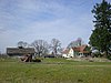 |
March 9, 1995 (#95000194) |
12504 Spanaway Loop Road 47°08′38″N 122°27′35″W / 47.14392°N 122.45966°W | Parkland | Also known as Lakeview Dairy and Schibig Farm. | |
| 69 | South Puyallup River Bridge |  |
March 13, 1991 (#91000198) |
Nisqually Entrance 46°48′29″N 121°53′26″W / 46.808114°N 121.890686°W | Mount Rainier National Park | Built in 1931. |
| 70 | Steilacoom Catholic Church | 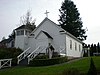 |
July 30, 1974 (#74001972) |
1810 Nisqually Street 47°10′16″N 122°35′37″W / 47.171194°N 122.593586°W | Steilacoom | Also known as the Church of the Immaculate Conception, this church was originally built in 1855 near Fort Steilacoom, but was moved to its present location in Steilacoom in 1864.[29] It was the first Catholic church built in Washington.[30] |
| 71 |  |
November 24, 1975 (#75001865) |
Between Nisqually Street and Puget Sound. 47°10′18″N 122°35′56″W / 47.17154°N 122.598885°W | Steilacoom | Steilacoom was the first incorporated community in Washington in 1853.[31] The Historic District consists of 1,500 acres (6.1 km2) and 38 buildings. | |
| 72 | Summerland Trail Shelter |  |
March 13, 1991 (#91000185) |
Sunrise 46°51′55″N 121°39′28″W / 46.865372°N 121.6578°W | Mount Rainier National Park | |
| 73 | Sunrise Comfort Station | March 13, 1991 (#91000207) |
Sunrise 46°54′40″N 121°39′32″W / 46.911031°N 121.659011°W | Mount Rainier National Park | ||
| 74 | Sunrise Historic District |  |
March 13, 1991 (#91000175) |
Sunrise 46°54′53″N 121°38′32″W / 46.914722°N 121.642222°W | Mount Rainier National Park | |
| 75 | Sunset Park Patrol Cabin |  |
March 13, 1991 (#91000186) |
46°52′58″N 121°53′54″W / 46.882881°N 121.898333°W | Mount Rainier National Park | |
| 76 | Sunset Park Trail Shelter | March 13, 1991 (#91000187) |
46°52′59″N 121°53′49″W / 46.883136°N 121.896883°W | Mount Rainier National Park | ||
| 77 | Suntop Lookout | 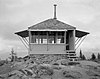 |
July 14, 1987 (#87001192) |
White River Ranger District on Suntop Mountain. 47°02′29″N 121°35′37″W / 47.041297°N 121.5935°W | Enumclaw | Built in 1933, this fire lookout was also used in the Army Aircraft Warning Service during World War II.[32] |
| 78 | Tahoma Vista Comfort Station | March 13, 1991 (#91000205) |
Nisqually Entrance 46°47′43″N 121°52′51″W / 46.795239°N 121.880731°W | Mount Rainier National Park | ||
| 79 | Thornewood | 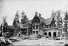 |
March 18, 1982 (#82004283) |
8601 and 8307 N. Thorne Lane, SW and 4 Thornewood Lane, SW 47°07′47″N 122°32′54″W / 47.12962°N 122.548237°W | Lakewood | Consists of three buildings, including Thornewood Castle, which was built from the brick of a dismantled 15th century house imported from England.[33] The Castle was used as a set for the Stephen King film Rose Red.[34] |
| 80 | Tipsoo Lake Comfort Station |  |
March 13, 1991 (#91000206) |
Chinook Pass 46°52′13″N 121°31′09″W / 46.870319°N 121.519114°W | Mount Rainier National Park | |
| 81 | Tolmie Peak Fire Lookout | 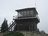 |
March 13, 1991 (#91000195) |
46°57′28″N 121°52′49″W / 46.957847°N 121.880233°W | Mount Rainier National Park | |
| 82 |  |
June 7, 1978 (#78002770) |
East of Wilkeson 47°06′15″N 122°01′54″W / 47.104134°N 122.031591°W | Wilkeson | District consists of 400 acres (1.6 km2), two buildings, five structures, and eight objects. | |
| 83 | White River Bridge | 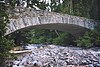 |
March 13, 1991 (#91000200) |
46°53′53″N 121°37′04″W / 46.898194°N 121.617861°W | Mount Rainier National Park | |
| 84 | White River Entrance |  |
March 13, 1991 (#91000177) |
46°54′08″N 121°33′14″W / 46.902222°N 121.553889°W | Mount Rainier National Park | District consists of 49 acres (20 ha) and three buildings. |
| 85 | White River Mess Hall and Dormitory |  |
March 13, 1991 (#91000328) |
46°54′08″N 121°33′16″W / 46.902269°N 121.554339°W | Mount Rainier National Park | |
| 86 | White River Patrol Cabin |  |
March 13, 1991 (#91000190) |
46°54′10″N 121°38′15″W / 46.902661°N 121.637569°W | Mount Rainier National Park | |
| 87 | Wilkeson Arch |  |
August 10, 2000 (#00000973) |
State Route 165, Church St. and Brierhill Blvd. 47°06′38″N 122°03′03″W / 47.110481°N 122.050756°W | Wilkeson | Built in 1925 by the town booster club,[35] the arch was damaged in the 2001 Nisqually earthquake. |
| 88 |  |
July 17, 2013 (#13000507) |
540 Church St. 47°06′15″N 122°02′46″W / 47.104200°N 122.046164°W | Wilkeson | ||
| 89 | Wilkeson School | 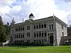 |
October 8, 1976 (#76001905) |
640 Railroad Ave. 47°06′06″N 122°02′33″W / 47.101667°N 122.0425°W | Wilkeson | Also known as Wilkeson Elementary School, it is the oldest used elementary school in Washington.[35] |
| 90 |  |
October 18, 1984 (#84000172) |
1711 Elm Street 47°12′39″N 122°13′51″W / 47.21095°N 122.230931°W | Sumner | Also known as Perfield House. | |
| 91 |  |
October 18, 1984 (#84000179) |
15003 E. Elm Street 47°12′40″N 122°13′44″W / 47.211111°N 122.228889°W | Sumner | Also known as the Moser House. | |
| 92 | Winnifred Street Bridge |  |
March 28, 1995 (#95000259) |
Winnifred St. over the Burlington Northern RR tracks. 47°17′52″N 122°30′43″W / 47.297753°N 122.512067°W | Ruston | Originally built in 1941, it was rebuilt in 2003. Bridges of Washington State MPS |
| 93 | July 15, 1987 (#87001168) |
3409 E. Bay Drive 47°16′08″N 122°34′59″W / 47.268789°N 122.583056°W | Gig Harbor | Was used as a private residence until it burned to the ground in a wood stove accident. Building is no longer in existence. Address listed is of the property owner, not the location of the school property. Lat-long listed are correct for the school property.[7] Rural Public Schools of Washington State MPS | ||
| 94 |  |
August 29, 1997 (#97001083) |
6122 150th St. SW 47°07′11″N 122°31′17″W / 47.119803°N 122.521472°W | Lakewood | Established in 1924. | |
| 95 |  |
October 13, 1983 (#83004260) |
176th Street, E. (Leach Rd.) 47°05′52″N 122°13′27″W / 47.097863°N 122.224099°W | Orting vicinity | Building no longer exists. | |
| 96 | Yakima Park Stockade Group |  |
May 28, 1987 (#87001337) |
Sunrise (Yakima Park) 46°54′49″N 121°38′32″W / 46.913697°N 121.642347°W | Mount Rainier National Park | Founded c. 1935, the district consists of 35 acres (14 ha), three buildings, one structure, and one object. |

Tacoma[]
| [3] | Name on the Register | Image | Date listed[5] | Location | Neighborhood | Description |
|---|---|---|---|---|---|---|
| 1 | May 1, 1991 (#91000537) |
Camp Murray 47°07′32″N 122°33′45″W / 47.125456°N 122.562622°W | Camp Murray | Also known as Building 118, once housed the Washington National Guard Museum. | ||
| 2 | Albers Brothers Mill |  |
March 19, 2002 (#02000247) |
1821 Dock Street 47°14′42″N 122°26′01″W / 47.245066°N 122.433637°W | Built in 1904, with additions in 1912, this building served as a mill until 1944. Now houses apartments.[36] | |
| 3 |  |
May 19, 2009 (#09000218) |
9600 Veterans Dr. SW 47°08′04″N 122°34′40″W / 47.134506°N 122.577703°W | |||
| 4 |  |
July 28, 1999 (#99000919) |
319–323 North I Street 47°15′41″N 122°27′14″W / 47.261389°N 122.453781°W | This Italianate style building was built in 1925.[36] | ||
| 5 |  |
January 23, 2008 (#07001458) |
1308–1310 Fawcett Avenue 47°15′02″N 122°26′33″W / 47.250474°N 122.442555°W | Also known as the Crescent Ballroom, the auditorium was built in 1922 by architect Roland E. Borhek, and held concerts ranging from Rudolph Valentino in 1923, to Nirvana in 1990.[37] | ||
| 6 |  |
November 16, 2006 (#06001214) |
705 Dock Street 47°15′29″N 122°28′13″W / 47.257931°N 122.470406°W | The building was built in 1900, and is home to the Working Waterfront Maritime Museum.[38] | ||
| 7 |  |
June 15, 2007 (#07001459) |
701 N. 10th 47°16′04″N 122°27′42″W / 47.26773°N 122.46158°W | Built in 1909. | ||
| 8 | Blue Mouse Theatre |  |
January 13, 2010 (#09001235) |
2611 N. Proctor St. 47°16′18″N 122°29′19″W / 47.271628°N 122.488731°W | ||
| 9 |  |
November 23, 1979 (#79002553) |
100 S. 9th Street 47°15′20″N 122°26′15″W / 47.255569°N 122.437386°W | Built in 1919. | ||
| 10 | Browns Point Lighthouse & Keeper's Cottage |  |
March 29, 1989 (#89000208) |
201 Tulalip, NE. 47°18′22″N 122°26′33″W / 47.305983°N 122.442406°W | Built in 1933 | |
| 11 |  |
December 20, 2016 (#16000882) |
Roughly bounded by N. Steele, N. 8th, N. Pine & N. 21st Sts. 47°15′40″N 122°28′15″W / 47.261108°N 122.470883°W | |||
| 12 |  |
March 16, 1995 (#95000222) |
1602 S. G St. 47°14′51″N 122°26′38″W / 47.247411°N 122.443814°W | Built in 1890, this building was originally built as the Hillside Grocery.[36] | ||
| 13 |  |
March 16, 1995 (#95000226) |
712–716 6th Ave. 47°15′27″N 122°26′45″W / 47.257411°N 122.445956°W | Built in 1925, the building originally housed three separate business, the Hob Nob Restaurant now occupies the entire building.[39] | ||
| 14 |  |
December 13, 1977 (#77001354) |
Northwest of Tacoma on Salmon Beach 47°17′37″N 122°31′44″W / 47.293594°N 122.5289°W | Salmon Beach | Also known as Walter Crooks Cabin. | |
| 15 |  |
March 7, 1973 (#73001885) |
Point Defiance Park 47°18′12″N 122°31′38″W / 47.30321°N 122.52726°W | Point Defiance Park | Also known as Western Washington Forest Industries Museum, the museum is designed to look like an actual logging camp.[40] | |
| 16 |  |
December 24, 2013 (#13000998) |
601 S. 8th St. 47°15′21″N 122°26′44″W / 47.255845°N 122.445567°W | Now home to Tacoma Public Schools headquarters | ||
| 17 | City Waterway Bridge |  |
July 16, 1982 (#82004278) |
11th Avenue, spans Thea Foss Waterway. 47°15′14″N 122°25′57″W / 47.254014°N 122.432381°W | Built in 1911, it is also known as Murray Morgan Bridge. Historic Bridges and Tunnels in Washington TR | |
| 18 |  |
April 21, 2014 (#14000167) |
2101 S. Tacoma Way 47°13′55″N 122°27′52″W / 47.231816°N 122.464473°W | Now known as Bob's Java Jive | ||
| 19 |  |
October 10, 2017 (#100001723) |
Roughly bounded by N. Union Ave., N. Pine, N. 21st, N. Alder, N. 8th & N. 18th Sts. 47°15′46″N 122°28′32″W / 47.262717°N 122.475607°W | |||
| 20 |  |
December 29, 2014 (#14001108) |
3713 N. 19th St. 47°16′00″N 122°29′13″W / 47.2666°N 122.4869°W | |||
| 21 |  |
July 20, 1977 (#77001351) |
9 St. Helens Street 47°15′49″N 122°26′41″W / 47.263703°N 122.444833°W | Built in 1888. | ||
| 22 | East 34th Street Bridge |  |
July 16, 1982 (#82004279) |
East 34th Street from Pacific Avenue to A Street 47°14′19″N 122°25′55″W / 47.238496°N 122.431902°W | Built in 1937. Historic Bridges and Tunnels in Washington TR | |
| 23 | Engine House No. 4 |  |
October 18, 1984 (#84002425) |
220–224 E. 26th Street 47°14′19″N 122°25′45″W / 47.238522°N 122.429242°W | Built in 1911. No longer in service as a fire station, today it is used by the City of Tacoma's traffic signal division.[36] | |
| 24 | Engine House No. 8 |  |
May 2, 1986 (#86000968) |
4301 S. L St 47°13′06″N 122°26′52″W / 47.218456°N 122.447683°W | Built in 1909. This station was replaced in 2006 with a larger facility, and is now a private residence. | |
| 25 | Engine House No. 9 |  |
July 30, 1975 (#75001866) |
611 N. Pine Street 47°15′23″N 122°28′20″W / 47.256364°N 122.472136°W | Built in 1907. This station was replaced in the 1960s with a larger facility, and is now a private fire service-themed bar and grill. | |
| 26 | Engine House No. 11 |  |
May 2, 1986 (#86000965) |
3802 McKinley Avenue 47°13′23″N 122°25′11″W / 47.223086°N 122.419767°W | Built in 1909, this is still an active fire station. | |
| 27 | Engine House No. 13 |  |
May 2, 1986 (#86000964) |
3825 N. Twenty-fifth Street 47°16′14″N 122°29′15″W / 47.270469°N 122.487464°W | Built in 1907, this is still an active fire station. | |
| 28 |  |
May 2, 1986 (#86000980) |
415 S. Tacoma Avenue 47°15′34″N 122°26′41″W / 47.259564°N 122.444611°W | Built in 1928, this facility is still as the fire alarm dispatch center today. | ||
| 29 | Fire Station No. 1 |  |
May 2, 1986 (#86000974) |
425 S. Tacoma Avenue 47°15′32″N 122°26′40″W / 47.259022°N 122.444486°W | Built in 1919, this building has not served as a fire station in decades, but is still owned by the fire department and used for storage purposes. It is adjacent to the Fire Alarm Station. | |
| 30 | Fire Station No. 2 | 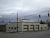 |
May 2, 1986 (#86000972) |
2701 S. Tacoma Avenue 47°14′11″N 122°26′21″W / 47.236319°N 122.439042°W | Built in 1907 and heavily remodeled in 1935, this is still an active fire station. | |
| 31 | Fire Station No. 5 |  |
May 2, 1986 (#86000971) |
1453 S. 12th Street 47°15′03″N 122°27′19″W / 47.250706°N 122.455278°W | Built in 1935, this is still an active fire station. It was renumbered as Fire Station No. 4 when the previous station 4 was closed. | |
| 32 | Fire Station No. 10 |  |
May 2, 1986 (#86000966) |
7247 S. Park Avenue 47°11′26″N 122°26′25″W / 47.190522°N 122.440186°W | Built in 1928, this is still an active fire station.. | |
| 33 | Fire Station No. 14 |  |
May 2, 1986 (#86000962) |
4701 N. 41st Street 47°17′10″N 122°29′56″W / 47.286089°N 122.49895°W | Built in 1928, this is still an active fire station.. | |
| 34 | Fire Station No. 15 |  |
May 2, 1986 (#86000961) |
3510 E. 11th Street 47°16′31″N 122°23′47″W / 47.2754°N 122.396368°W | This Mediterranean style fire station, built in 1928, was closed in 2006 when Engine 15 was relocated to southeast Tacoma. The building is still owned by the Fire Department and is used for storage.[36] | |
| 35 |  |
December 2, 1983 (#83004254) |
Marine Park on Ruston Way 47°17′20″N 122°29′22″W / 47.288792°N 122.489403°W | Built in 1929, retired from active duty in 1985. | ||
| 36 | Fireboat Station |  |
May 2, 1986 (#86000978) |
302 E. 11th Street 47°15′16″N 122°25′51″W / 47.254456°N 122.430789°W | Built in 1928 as part of a project that built three other stations, as well as the Fire Alarm Station. While the fireboats are still housed here, the station itself is no longer staffed.[36] | |
| 37 | Fort Nisqually Granary and Factor's House | 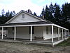 |
April 15, 1970 (#70000647) |
Point Defiance Park 47°18′13″N 122°31′58″W / 47.303476°N 122.532685°W | Point Defiance Park | Both buildings have been moved to Point Defiance Park, and a replica of the original Fort Nisqually as a living museum. |
| 38 |  |
January 27, 1983 (#83003349) |
4301 N. Stevens 47°17′17″N 122°29′39″W / 47.287939°N 122.494078°W | Originally built in 1922, for John Weyerhauser and his wife, the building now houses a Baptist seminary. | ||
| 39 |  |
March 10, 1995 (#95000230) |
1510 Tacoma Ave., S. 47°14′53″N 122°26′32″W / 47.248033°N 122.442356°W | This Queen Anne Style home was built in 1902. It has since been subdivided to accommodate two residences.[36] | ||
| 40 |  |
March 10, 1995 (#95000223) |
1610 S. G St. 47°14′50″N 122°26′38″W / 47.247142°N 122.44395°W | Built in 1911, this house once served as the rectory for the Japanese Methodist Church on the same block.[36] | ||
| 41 |  |
March 10, 1995 (#95000220) |
2314 S. Ainsworth Ave. 47°14′21″N 122°27′18″W / 47.239094°N 122.454867°W | Built in 1926. | ||
| 42 |  |
March 10, 1995 (#95000225) |
2326 S. L St. 47°14′17″N 122°26′56″W / 47.237986°N 122.4488°W | Built in 1904. | ||
| 43 |  |
March 10, 1995 (#95000221) |
605 S. G St. 47°15′28″N 122°26′44″W / 47.257858°N 122.445556°W | A Stick Style home built in 1906, also called the James Agnew Residence.[39] | ||
| 44 |  |
March 10, 1995 (#95000224) |
708 S. 8th St. 47°15′19″N 122°26′53″W / 47.25535°N 122.447961°W | Built in 1908, it is also known as the Buren/Holden Apartments[39] | ||
| 45 |  |
March 10, 1995 (#95000229) |
802–804 S. G St. 47°15′20″N 122°26′45″W / 47.255608°N 122.445711°W | Built in 1890, it is also known as the Thomas Carroll Double House.[39] | ||
| 46 | MV Kalakala (ferry) |  |
March 22, 2006 (#06000177) |
Hylebos Creek Waterway, 1801 Taylor Way 47°16′31″N 122°23′12″W / 47.27514°N 122.38662°W | Built in 1926, it is an Art Deco styled ferry that served the Washington State Ferry System from 1935 to 1967.[41] | |
| 47 | 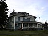 |
November 2, 2007 (#07001385) |
2902 N. Cedar Street 47°16′26″N 122°28′34″W / 47.27395°N 122.47623°W | NRHP ID# 07001385 | ||
| 48 |  |
November 30, 2005 (#05001352) |
717 Tacoma Ave. S 47°15′29″N 122°26′42″W / 47.258008°N 122.444906°W | This Classical Revival building, built in 1918, served as a funeral home until 2004.[36] | ||
| 49 |  |
November 2, 2007 (#07001386) |
1302–1306 S. Fawcett Avenue 47°15′02″N 122°26′33″W / 47.250663°N 122.442581°W | Built in 1918, in 1942 the building was merged with the next door Auditorium Dance Hall to form a single venue.[42] | ||
| 50 | Masonic Temple Building-Temple Theater |  |
April 29, 1993 (#93000357) |
47 St. Helens Avenue 47°15′43″N 122°26′39″W / 47.262081°N 122.444189°W | Built in 1927, this Art Deco building houses Washington's largest dancefloor.[43] | |
| 51 | McChord Field Historic District | December 12, 2008 (#08001026) |
McChord Air Force Base 47°08′24″N 122°28′45″W / 47.139917°N 122.479108°W | |||
| 52 |  |
March 16, 1995 (#95000227) |
920 S. 9th Street 47°15′12″N 122°27′27″W / 47.253236°N 122.457497°W | Built in 1909. | ||
| 53 |  |
August 23, 1985 (#85001810) |
402 N. Sheridan Avenue 47°15′32″N 122°27′25″W / 47.258903°N 122.456911°W | Built in 1902, this Gothic style home became an alcoholism treatment center in the 1930s. It is now apartments.[36] | ||
| 54 | National Bank of Tacoma |  |
August 2, 2006 (#06000671) |
1123 Pacific Ave 47°15′11″N 122°26′19″W / 47.25313°N 122.43855°W | Built in 1922, the building is now home to the Tacoma Art Museum.[44] | |
| 55 | Nihon Go Gakko |  |
August 30, 1984 (#84003568) |
1715 S. Tacoma Ave. 47°14′52″N 122°26′30″W / 47.24785°N 122.441564°W | Also known as the Japanese Language School, the building was built in 1922, and used to gather Japanese residents during World War II, before sending them to internment camps.[45] The building was demolished in 2004 after standing vacant since the 1940s. | |
| 56 |  |
April 25, 2001 (#01000429) |
2416 S. C Street 47°14′21″N 122°26′10″W / 47.23905°N 122.436236°W | Built in 1911. | ||
| 57 | North 21st Street Bridge |  |
July 16, 1982 (#82004280) |
Spans Buckley Gulch, N. Fife and Oakes 47°16′03″N 122°28′11″W / 47.267419°N 122.469647°W | Built in 1910. Historic Bridges and Tunnels in Washington TR | |
| 58 | North 23rd Street Bridge |  |
July 16, 1982 (#82004281) |
Spans Buckley Gulch, N. Fife and Oakes 47°16′40″N 122°28′14″W / 47.277861°N 122.470467°W | Built in 1909. Historic Bridges and Tunnels in Washington TR | |
| 59 | North Slope Historic District |  |
March 28, 2003 (#03000160) |
Area bounded by Division Ave., N. Grant Ave, N. Steele St., and N. I St. 47°15′41″N 122°27′45″W / 47.261439°N 122.462511°W | Consists of 2,280 acres (9.2 km2), 698 buildings, and 211 structures. | |
| 60 | Northern Pacific Office Building |  |
May 4, 1976 (#76001901) |
Northeastern corner of 7th St. and Pacific Ave. 47°15′27″N 122°26′17″W / 47.25755°N 122.438025°W | Built in 1891, part of the building was demolished and turned into a park in 1920, when Northern Pacific's offices were transferred to Seattle.[46] | |
| 61 | Old City Hall |  |
May 17, 1974 (#74001973) |
7th Avenue between Commerce and Pacific Avenue 47°15′27″N 122°26′19″W / 47.257464°N 122.438556°W | This Renaissance style building, designed by E.A. Hatherton, served as Tacoma's City Hall from 1893 to 1959.[47] | |
| 62 | Old City Hall Historic District |  |
December 23, 1977 (#77001352) |
Roughly bounded by St. Helens Ave., Court C, freeway spur, 7th and 9th Streets. 47°15′22″N 122°26′30″W / 47.256239°N 122.441547°W | Consists of 165 acres (0.67 km2), 20 buildings, and one structure. | |
| 63 |  |
July 31, 1978 (#78002768) |
S. 25th St. between C St. and Jefferson Avenue 47°14′18″N 122°26′11″W / 47.238286°N 122.436378°W | Founded in 1888, the brewery closed in 1916, after Washington passed laws prohibiting alcohol.[48] The site consists of thirteen buildings. | ||
| 64 | Pacific National Bank Building |  |
March 7, 1980 (#80004008) |
1302 Pacific Avenue 47°15′05″N 122°26′12″W / 47.251292°N 122.436769°W | Built in 1891, the building by Burnham and Root was also known as the Luzon Building. Demolished September 2009.[49] | |
| 65 | Pantages Theatre |  |
November 7, 1976 (#76001902) |
901 and 909 Broadway 47°15′19″N 122°26′22″W / 47.255219°N 122.439503°W | Built in 1916, it is the oldest remaining of several theaters built for Alexander Pantages.[50][44] | |
| 66 | Perkins Building |  |
November 22, 2000 (#00001444) |
1101 A Street 47°15′46″N 122°26′05″W / 47.2628°N 122.434797°W | Built in 1907. | |
| 67 |  |
August 28, 2017 (#100001518) |
5715 Roberts Garden Rd. 47°18′18″N 122°31′02″W / 47.305103°N 122.517255°W | Point Defiance Park | ||
| 68 |  |
January 8, 2014 (#13001060) |
5801 Trolley Lane 47°18′21″N 122°31′02″W / 47.305859°N 122.517166°W | Point Defiance Park | ||
| 69 | Pythian Temple |  |
August 23, 1985 (#85001811) |
924–926½ Broadway 47°15′17″N 122°26′23″W / 47.254858°N 122.439639°W | Built in 1906. | |
| 70 |  |
November 21, 1978 (#78002769) |
740 St. Helens Avenue 47°15′22″N 122°26′26″W / 47.256122°N 122.440419°W | Built in 1930, this Art Deco building now houses the Tacoma City Hall. | ||
| 71 | Henry A. and Birdella Rhodes House |  |
August 2, 2006 (#06000670) |
701 North J Street 47°15′49″N 122°27′34″W / 47.263743°N 122.459377°W | This Queen Anne Style home was built in 1901.[36] | |
| 72 | Rialto Theater |  |
August 21, 1992 (#92001041) |
310 9th Street 47°15′18″N 122°26′24″W / 47.255042°N 122.439903°W | Built in 1918, this is a Beaux-Arts style theater.[51] | |
| 73 | William Ross Rust House |  |
August 23, 1985 (#85001806) |
1001 N. I Street 47°15′59″N 122°27′41″W / 47.266481°N 122.461328°W | Built in 1905 for William Ross Rust, then President of the Tacoma Smelter and Refining Company. | |
| 74 | St. Peter's Episcopal Church |  |
November 5, 1974 (#74001974) |
Starr between 29th and 30th Streets 47°16′28″N 122°27′45″W / 47.274317°N 122.462439°W | Built in 1873, it is the oldest building in Tacoma. | |
| 75 |  |
August 12, 1999 (#99001008) |
1411–1423 Pacific Avenue 47°14′57″N 122°28′35″W / 47.249231°N 122.476503°W | Built in 1907. | ||
| 76 |  |
March 16, 1995 (#95000228) |
1002 S. 12th Street 47°15′04″N 122°26′57″W / 47.251036°N 122.449061°W | Built in 1911. | ||
| 77 |  |
November 7, 1976 (#76001903) |
2306 N. 30th Street 47°16′28″N 122°28′00″W / 47.274514°N 122.466667°W | Built in 1901, as a fraternal lodge by the Slavonian Benevolent Society.[52] | ||
| 78 |  |
May 8, 1986 (#86001020) |
Area bounded by west side of S. J St. between S. Seventh and S. Eighth Streets 47°15′21″N 122°27′04″W / 47.255758°N 122.451136°W | Includes less than 1-acre (4,000 m2), and eight buildings, seven of which are in the Queene Anne style.[39] | ||
| 79 |  |
November 21, 1985 (#85002920) |
1501–1505 Pacific Avenue 47°14′57″N 122°26′09″W / 47.249261°N 122.4358°W | Built in 1889. | ||
| 80 | Stadium-Seminary Historic District |  |
May 26, 1977 (#77001353) |
Roughly bounded by 1st, I, and 10th Streets and shoreline. 47°16′02″N 122°27′18″W / 47.267347°N 122.455006°W | Encompasses 2,000 acres (8.1 km2) and 402 buildings. | |
| 81 |  |
August 23, 1985 (#85001809) |
1101 Fawcett Avenue 47°15′11″N 122°26′28″W / 47.252978°N 122.441114°W | Built in 1901. | ||
| 82 |  |
October 22, 2001 (#01001162) |
1015–1021 A Street 47°15′46″N 122°26′05″W / 47.2628°N 122.434797°W | Also known as the Weyerhaeuser Headquarters Building. | ||
| 83 |  |
December 7, 2010 (#10000994) |
2602 S. Holgate St. 47°14′16″N 122°26′15″W / 47.237778°N 122.4375°W | |||
| 84 | Tacoma Mausoleum |  |
April 21, 2000 (#00000405) |
5302 S. Junett Street 47°12′33″N 122°28′28″W / 47.209178°N 122.474322°W | Built in 1910. | |
| 85 | Tacoma Narrows Bridge Ruins |  |
August 31, 1992 (#92001068) |
State Route 16 over the Tacoma Narrows 47°16′02″N 122°33′02″W / 47.26735°N 122.55043°W | Tacoma Narrows | Built in 1940, but collapsed just four months later during a windstorm. |
| 86 |  |
May 30, 1991 (#91000657) |
1102 S. A Street 47°15′11″N 122°26′10″W / 47.253044°N 122.436222°W | Built in 1910. | ||
| 87 |  |
April 2, 1980 (#80004009) |
Roughly bounded by railroad tracks, 15th, 23rd and Market Streets 47°14′43″N 122°26′17″W / 47.245387°N 122.438080°W | Consists of 26.5 acres (10.7 ha) and 34 buildings. The building shown here is The Swiss. | ||
| 88 | Union Passenger Station |  |
March 15, 1974 (#74001975) |
1713 Pacific Avenue 47°14′45″N 122°26′11″W / 47.245922°N 122.436335°W | The station was completed in 1911 from a design by Reed and Stem, the same architects that designed Grand Central Station in New York City.[53] | |
| 89 |  |
May 16, 1994 (#94000420) |
405 6th Avenue 47°15′31″N 122°26′32″W / 47.258742°N 122.442242°W | Built in 1927. | ||
| 90 |  |
June 29, 2009 (#09000508) |
1019 Pacific Ave. 47°15′13″N 122°26′18″W / 47.253633°N 122.438242°W | |||
| 91 |  |
August 23, 2006 (#06000729) |
3701 N. 26th Street 47°16′16″N 122°29′12″W / 47.27119°N 122.48663°W | Also known as Washington-Hoyt Elementary School. | ||
| 92 |  |
December 13, 2016 (#16000856) |
Triangle area bounded by Division and 6th Aves., and South M St. 47°15′33″N 122°27′33″W / 47.259173°N 122.459045°W | |||
| 93 |  |
December 26, 2012 (#12001100) |
1120 S. 39th St. 47°15′37″N 122°26′57″W / 47.26027°N 122.44909°W | |||
| 94 | Wright Park and Seymour Conservatory |  |
October 8, 1976 (#76001904) |
Division Ave. to 6th Ave., between S. G and I Street 47°15′37″N 122°26′57″W / 47.26027°N 122.44909°W | Wright Park was established in 1886, the conservatory was added in 1907.[54] | |
| 95 |  |
January 27, 1983 (#83003353) |
714 Market Street 47°15′26″N 122°26′29″W / 47.257155°N 122.441365°W | Built in 1908. | ||
| 96 |  |
August 23, 1985 (#85001807) |
519 S. G Street 47°15′31″N 122°26′45″W / 47.258578°N 122.445811°W | Built in 1888. |
Former listings[]
| [3] | Name on the Register | Image | Date listed | Date removed | Location | City or town | Description |
|---|---|---|---|---|---|---|---|
| 1 |  |
July 16, 1982 (#82004282) | Unknown | Dock Street | Tacoma | ||
| 2 |  |
April 14, 1983 (#83003351) | July 16, 1990 | 1302–1356 Pacific Ave. | Tacoma | ||
| 3 | February 18, 1975 (#75001867) | July 16, 1990 | 1156 S. Fawcett St. | Tacoma |
See also[]
| Wikimedia Commons has media related to National Register of Historic Places in Pierce County, Washington. |
- List of National Historic Landmarks in Washington
- National Register of Historic Places listings in Washington state
References[]
- ^ The latitude and longitude information provided in this table was derived originally from the National Register Information System, which has been found to be fairly accurate for about 99% of listings. Some locations in this table may have been corrected to current GPS standards.
- ^ National Park Service, United States Department of the Interior, "National Register of Historic Places: Weekly List Actions", retrieved September 3, 2021.
- ^ Jump up to: a b c Numbers represent an alphabetical ordering by significant words. Various colorings, defined here, differentiate National Historic Landmarks and historic districts from other NRHP buildings, structures, sites or objects.
- ^ "National Register Information System". National Register of Historic Places. National Park Service. April 24, 2008.
- ^ Jump up to: a b The eight-digit number below each date is the number assigned to each location in the National Register Information System database, which can be viewed by clicking the number.
- ^ Galentine 2006, p. 105
- ^ Jump up to: a b Roberts 1999, p. 289
- ^ "Ashford Mansion - Introduction". Retrieved 2008-02-19.
- ^ Dunkelberger 2005, p. 23
- ^ Filley 1996, p. 221
- ^ Price, p. 34
- ^ Roberts 1999, p. 311
- ^ Jump up to: a b c Kirk 1995, p. 341
- ^ "Sumner Walking Tour" (PDF). Archived from the original (PDF) on 2007-11-07. Retrieved 2008-02-19.
- ^ Filley 1996, p. 14
- ^ Kirk 1995, p. 320
- ^ Holstine 2005, p. 204
- ^ Halliday 2000, p. 55
- ^ "Historic Fort Steilacoom". Retrieved 2008-02-24.
- ^ Roberts 1999, p. 287
- ^ Jump up to: a b Roberts 1999, p. 290
- ^ "Upper Nisqually Valley Community Plan" (PDF). Archived from the original (PDF) on 2007-10-16. Retrieved 2008-02-19.
- ^ Filley 1996, p. 135
- ^ "Mount Rainier Historic Structures". Retrieved 2008-02-23.
- ^ Roberts 1999, p. 299
- ^ Samson 2006, p. 311
- ^ "City of Sumner - Ryan House". Archived from the original on 2007-11-07. Retrieved 2008-02-19.
- ^ "Archived copy". Archived from the original on 2011-08-17. Retrieved 2011-09-10.CS1 maint: archived copy as title (link)
- ^ Dunkelberger, p. 16
- ^ Roberts 1999, p. 298
- ^ Roberts 1999, p. 296
- ^ "American Memory from the Library of Congress". Retrieved 2008-03-20.
- ^ Coulombe 2005, p. 268
- ^ Dunkelberger 2005, p. 51
- ^ Jump up to: a b Candy Hatcher (October 25, 2000). "Evergreen Journal: Double life of an old ghost town". Retrieved 2008-02-19.
- ^ Jump up to: a b c d e f g h i j k "Tacoma Historic Property Inventory". Archived from the original on 2007-08-21. Retrieved 2008-03-01.
- ^ John Gillie (February 19, 2008). "Fresh start for historic venue". The News Tribune. Retrieved 2008-02-19.[dead link]
- ^ Kelly Kearsley (February 17, 2007). "Shoring up the waterfront museum's home". The News Tribune. Archived from the original on August 8, 2007. Retrieved 2008-02-19.
- ^ Jump up to: a b c d e Landmarks Preservation Commission. "Hilltop Web Version" (PDF). Retrieved 2008-02-19.
- ^ Filley 1996, p. 18
- ^ Wootton 2007, p. 42
- ^ "Minutes: Landmarks Preservation Commission" (PDF). Retrieved 2008-02-23.[dead link]
- ^ Roberts 1999, p. 308
- ^ Jump up to: a b Kirk 1995, p. 336
- ^ "University to commemorate Japanese Language School". November 13, 2003. Archived from the original on August 14, 2007. Retrieved 2008-02-19.
- ^ Kirk 1995, p. 337
- ^ "The Tacoma Historical Society". Retrieved 2008-02-19.
- ^ Ed Murrieta (July 27, 2005). "Toast of Tacoma". Archived from the original on 2008-03-10. Retrieved 2008-02-19.CS1 maint: bot: original URL status unknown (link) .
- ^ Todd Matthews, Luzon's Last Dawn Archived 2009-10-18 at the Wayback Machine, Tacoma News-Tribune, September 26, 2009. Accessed online September 28, 2009.
- ^ Grau 1910, p. 143
- ^ Roberts 1999, p. 304
- ^ Kirk 1995, p. 338
- ^ Kirk 1995, p. 335
- ^ Kirk 1995, p. 340
Sources[]
- Coulombe, Charles A. (2005). Haunted Castles of the World: Ghostly Legends and Phenomena from Keeps and Fortresses Around the Globe, Globe Pequot, ISBN 1-59228-534-1.
- Dunkelberger, Steve; Neary, Walter (2005). Lakewood, Arcadia Publishing, ISBN 0-7385-3045-X.
- Filley, Bette (1996). The Big Fact Book About Mount Rainier, Dunamis House, ISBN 1-880405-06-7.
- Galentine, Elizabeth (2006). Anderson Island, Arcadia Publishing, ISBN 0-7385-4854-5.
- Grau, Robert (1910). The Business Man in the Amusement World: A Volume of Progress in the Field of the Theatre, Broadway Publishing Co.
- Halliday, Jan; Chehak, Gail (2000). Native Peoples of the Northwest: A Traveler's Guide to Land, Art, and Culture, Sasquatch Books, ISBN 1-57061-241-2.
- Holstine, Craig; Hobbs, Richard (2005). Spanning Washington: Historic Highway Bridges of the Evergreen State, Washington State University Press, ISBN 0-87422-281-8.
- Kirk, Ruth; Alexander, Carmela (1995). Exploring Washington's Past: A Road Guide to History, University of Washington Press, ISBN 0-295-97443-5.
- Price, Lori; Anderson, Ruth (2002). Puyallup: A Pioneer Paradise, Arcadia Publishing, ISBN 0-7385-2374-7.
- Roberts, George; Roberts, Jan (1999). Discover Historic Washington State, Gem Guides Book Company, ISBN 1-889786-07-1.
- Samson, Karl (2006). Frommer's Washington State, Frommer's, ISBN 0-470-03684-2.
- Smith, Giselle (2004). Best Places Northwest: The Best Restaurants, Lodgings, and a Complete Guide to the Region, Sasquatch Books, ISBN 1-57061-417-2.
- Wootton, Sharon; Savage, Maggie (2007). You Know You're in Washington When...: 101 Quintessential Places, People, Events, Customs, Lingo, and Eats of the Evergreen State, Globe Pequot, ISBN 0-7627-4301-8.
| show U.S. National Register of Historic Places in Washington state |
|---|

| show Municipalities and communities of Pierce County, Washington, United States |
|---|

| show U.S. National Register of Historic Places |
|---|
Categories:
- National Register of Historic Places in Pierce County, Washington
- Buildings and structures in Pierce County, Washington
- Lists of National Register of Historic Places in Washington (state) by county