[3] Name on the Register[4]
Image
Date listed[5]
Location
City or town
Description
1
March 15, 1982 (#82002273 ) 1502 Pacific Ave. 36°58′31″N 122°01′31″W / 36.975278°N 122.025278°W / 36.975278; -122.025278 (Bank of Santa Cruz County ) Santa Cruz Following the 1989 Loma Prieta earthquake , most of the building was demolished. The two stone-faced exterior walls, however, were saved. A new structure was built behind them.
2
March 30, 1992 (#92000259 ) 8041 Soquel Dr. 36°58′39″N 121°53′58″W / 36.9775°N 121.899444°W / 36.9775; -121.899444 (Bayview Hotel ) Aptos Built in 1878
3
Godfrey M. Bockius House
July 13, 1989 (#89000937 ) 322 E. Beach St. 36°54′58″N 121°44′51″W / 36.916111°N 121.7475°W / 36.916111; -121.7475 (Godfrey M. Bockius House ) Watsonville
4
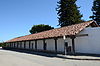
Branciforte Adobe
January 31, 1979 (#79000552 ) 1351 N. Branciforte Ave. 36°59′23″N 122°00′35″W / 36.989722°N 122.009722°W / 36.989722; -122.009722 (Branciforte Adobe ) Santa Cruz
5
Upload image June 25, 1981 (#81000178 ) Address Restricted Santa Cruz
6
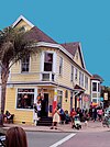
California Powder Works Bridge
February 27, 2015 (#15000279 ) Spanning San Lorenzo River at Keystone Way, Paradise Park 37°00′38″N 122°02′42″W / 37.0106°N 122.045°W / 37.0106; -122.045 (California Powder Works Bridge ) Santa Cruz
7
March 20, 1986 (#86000456 ) 315-321 Main St. 36°57′56″N 122°01′20″W / 36.965556°N 122.022222°W / 36.965556; -122.022222 (Carmelita Court ) Santa Cruz
8
Jose Joaquin Castro Adobe
December 12, 1976 (#76000531 ) NW of Watsonville at 184 Old Adobe Rd. 36°56′46″N 121°48′40″W / 36.946111°N 121.811111°W / 36.946111; -121.811111 (Jose Joaquin Castro Adobe ) Watsonville
9
January 28, 1982 (#82002274 ) 412-420 Lincoln St. 36°58′20″N 122°01′49″W / 36.972222°N 122.030278°W / 36.972222; -122.030278 (Cope Row Houses ) Santa Cruz located in the Santa Cruz Downtown Historic District
10
Cowell Lime Works Historic District
November 21, 2007 (#07001220 ) University of California, Santa Cruz campus; High St. and Glen Coolidge Dr. 36°58′41″N 122°03′08″W / 36.978102°N 122.052132°W / 36.978102; -122.052132 (Cowell Lime Works Historic District ) Santa Cruz On ranch land once owned by the Henry Cowell family, now part of the University of California, Santa Cruz campus
11
April 27, 1992 (#92000422 ) 1 Center St. 37°00′38″N 122°11′31″W / 37.010556°N 122.191944°W / 37.010556; -122.191944 (Davenport Jail ) Davenport
12
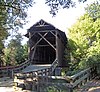
Felton Covered Bridge
June 19, 1973 (#73000451 ) Covered Bridge Road 37°03′03″N 122°04′15″W / 37.050797°N 122.070956°W / 37.050797; -122.070956 (Felton Covered Bridge ) Felton An 1890s wooden covered Brown truss bridge, tallest covered bridge in the U.S., entrance to Felton for 45 years, part of park now.
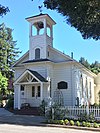
13
Felton Presbyterian Church
April 6, 1978 (#78000774 ) 6299 Gushee St. 37°03′10″N 122°04′24″W / 37.052778°N 122.073333°W / 37.052778; -122.073333 (Felton Presbyterian Church ) Felton
14
March 26, 1992 (#92000268 ) 705 Woodrow Ave. 36°57′29″N 122°02′16″W / 36.958056°N 122.037778°W / 36.958056; -122.037778 ��� (Garfield Park Branch Library ) Santa Cruz
15
Glen Canyon Covered Bridge
May 17, 1984 (#84001194 ) Branciforte Dr. 37°00′00″N 122°00′08″W / 37.0°N 122.002222°W / 37.0; -122.002222 (Glen Canyon Covered Bridge ) Santa Cruz demolished
16
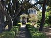
Golden Gate Villa
July 24, 1975 (#75000482 ) 924 3rd St. 36°58′02″N 122°01′18″W / 36.967222°N 122.021667°W / 36.967222; -122.021667 (Golden Gate Villa ) Santa Cruz
17
Grace Episcopal Church
December 19, 2006 (#06001158 ) 12547 CA 9 37°07′00″N 122°07′11″W / 37.116667°N 122.119722°W / 37.116667; -122.119722 (Grace Episcopal Church ) Boulder Creek
18
Headquarters Administration Building
December 22, 2015 (#15000914 ) 21600 Big Basin Way, Big Basin Redwoods State Park 37°10′19″N 122°13′20″W / 37.172070°N 122.222281°W / 37.172070; -122.222281 (Headquarters Administration Building ) Boulder Creek
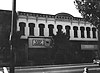
19
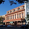
Hihn Building
March 20, 1973 (#73000450 ) 201 Monterey Ave. 36°58′23″N 121°56′58″W / 36.973056°N 121.949444°W / 36.973056; -121.949444 (Hihn Building ) Capitola
20
A. J. Hinds House
August 25, 1983 (#83001241 ) 529 Chestnut St. 36°58′25″N 122°01′48″W / 36.973611°N 122.03°W / 36.973611; -122.03 (A. J. Hinds House ) Santa Cruz located in the Santa Cruz Downtown Historic District
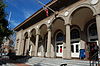
21
Hotel Metropole
May 23, 1979 (#79000553 ) 1111 Pacific Ave. 36°58′19″N 122°01′29″W / 36.971944°N 122.024722°W / 36.971944; -122.024722 (Hotel Metropole ) Santa Cruz demolished after 1989 Loma Prieta earthquake
22
Judge Lee House
June 30, 1980 (#80000868 ) 128 E. Beach St. 36°54′42″N 121°45′13″W / 36.911667°N 121.753611°W / 36.911667; -121.753611 (Judge Lee House ) Watsonville
23
September 24, 1992 (#92001278 ) 406 Main St. 36°54′37″N 121°45′19″W / 36.910278°N 121.755278°W / 36.910278; -121.755278 (Lettunich Building ) Watsonville
24
July 10, 1975 (#75000483 ) 105 Mentel Ave. 36°58′38″N 121°59′57″W / 36.977222°N 121.999167°W / 36.977222; -121.999167 (Live Oak Ranch ) Santa Cruz
25
Looff Carousel and Roller Coaster on the Santa Cruz Beach Boardwalk
February 27, 1987 (#87000764 ) Along Beach St. 36°57′52″N 122°00′51″W / 36.964444°N 122.014167°W / 36.964444; -122.014167 (Looff Carousel and Roller Coaster on the Santa Cruz Beach Boardwalk ) Santa Cruz
26
Upload image September 24, 2014 (#14000662 ) 7, 8, 9, 10, 14, 15 & 16 Sky Meadow Ln. 37°10′57″N 122°12′20″W / 37.182432°N 122.205580°W / 37.182432; -122.205580 (Lower Sky Meadow Residential Area Historic District ) Boulder Creek
27
February 2, 1984 (#84001195 ) 335 East Lake 36°54′57″N 121°45′06″W / 36.915833°N 121.751667°W / 36.915833; -121.751667 (Madison House ) Watsonville
28
August 18, 1983 (#83001242 ) 418-424 Main St. 36°54′38″N 121°45′21″W / 36.910556°N 121.755833°W / 36.910556; -121.755833 (Mansion House Hotel ) Watsonville
29
Mission Hill Area Historic District
May 17, 1976 (#76000530 ) Mission St. 36°58′39″N 122°01′43″W / 36.9775°N 122.028611°W / 36.9775; -122.028611 (Mission Hill Area Historic District ) Santa Cruz The present Holy Cross Church was built in 1889, on the site of the original Mission Santa Cruz
30
Neary-Rodriguez Adobe
February 24, 1975 (#75000484 ) 130-134 School St. 36°58′40″N 122°01′39″W / 36.977778°N 122.0275°W / 36.977778; -122.0275 (Neary-Rodriguez Adobe ) Santa Cruz part of the Mission Hill Area Historic District
31
Octagon Building
March 24, 1971 (#71000193 ) Corner of Front and Cooper Sts. 36°58′29″N 122°01′29″W / 36.974722°N 122.024722°W / 36.974722; -122.024722 (Octagon Building ) Santa Cruz
32
January 22, 1988 (#87000626 ) Blue Gum Ave., Capitola Ave., Riverview Ave., Riverview Dr., and Wharf Rd. 36°58′27″N 121°57′12″W / 36.974167°N 121.953333°W / 36.974167; -121.953333 (Old Riverview Historic District ) Capitola
33
Upload image August 4, 1983 (#83004369 ) CA 9 37°06′02″N 122°05′58″W / 37.100556°N 122.099444°W / 37.100556; -122.099444 (Phillipshurst-Riverwood ) Ben Lomond
34
Redman House
July 28, 2004 (#04000734 ) 1635 W. Beach Dr. 36°53′47″N 121°46′33″W / 36.896389°N 121.775833°W / 36.896389; -121.775833 (Redman House ) Watsonville
35
Rispin Mansion
March 14, 1991 (#91000286 ) 2200 Wharf Rd. 36°58′43″N 121°57′22″W / 36.978611°N 121.956111°W / 36.978611; -121.956111 (Rispin Mansion ) Capitola
36
January 9, 1998 (#97001634 ) 363 Ocean St. 36°58′24″N 122°01′02″W / 36.973333°N 122.017222°W / 36.973333; -122.017222 (Elias H. Robinson House ) Santa Cruz
37
Upload image June 20, 2008 (#08000528 ) Address Restricted Santa Cruz
38
July 27, 1989 (#89001005 ) Roughly Rincon St., Church St., Chestnut St., Walnut St., Cedar St., Laurel St., Myrtle St., and Lincoln St. 36°58′15″N 122°02′23″W / 36.970833°N 122.039722°W / 36.970833; -122.039722 (Santa Cruz Downtown Historic District ) Santa Cruz An 1870s house, typical of this Historic District
39
Hiram D. Scott House
April 13, 1977 (#77000348 ) 4603 Scotts Valley Drive 37°02′57″N 122°01′02″W / 37.049167°N 122.017222°W / 37.049167; -122.017222 (Hiram D. Scott House ) Scotts Valley
40
May 1, 1987 (#87000623 ) Roughly bounded by San Jose Ave., Capitola Ave., and Esplanade 36°58′21″N 121°57′40″W / 36.9725°N 121.961111°W / 36.9725; -121.961111 (Six Sisters-Lawn Way Historic District ) Capitola
41
April 7, 1983 (#83001243 ) 331–341 Main St. 36°54′34″N 121°45′20″W / 36.909444°N 121.755556°W / 36.909444; -121.755556 (Stoesser Block and Annex ) Watsonville Demolished prior to 2000.[6]
42
January 11, 1985 (#85000139 ) 850 Front St. 36°58′36″N 122°01′35″W / 36.976767°N 122.026416°W / 36.976767; -122.026416 (US Post Office-Santa Cruz Main ) Santa Cruz
43
Valencia Hall
September 20, 1984 (#84001201 ) Valencia Rd. 36°59′47″N 121°51′55″W / 36.996389°N 121.865278°W / 36.996389; -121.865278 (Valencia Hall ) Aptos
44
Venetian Court Apartments
April 2, 1987 (#87000574 ) 1500 Wharf Rd. 36°58′22″N 121°57′08″W / 36.972778°N 121.952222°W / 36.972778; -121.952222 (Venetian Court Apartments ) Capitola 1924 condominuiums
45
April 27, 1992 (#92000423 ) 842-846 Front St. 36°58′34″N 122°01′29″W / 36.976111°N 122.024722°W / 36.976111; -122.024722 (Veterans Memorial Building ) Santa Cruz
46
August 22, 1983 (#83001244 ) Bounded by Main, Peck, Union, and E. Beach Cts. 36°54′37″N 121°45′17″W / 36.910278°N 121.754722°W / 36.910278; -121.754722 (Watsonville City Plaza ) Watsonville
47
May 28, 1976 (#76000532 ) Address Restricted Watsonville
48
October 12, 2017 (#100001730 ) 9500 Central Ave. 37°05′26″N 122°05′24″W / 37.090682°N 122.090059°W / 37.090682; -122.090059 (Wee Kirk ) Ben Lomond