Neil's Harbour, Nova Scotia
This article on a place of local interest appears to contain only a small amount of verifiable information, may not be notable, or may overly focus on local-interest trivia. |
Neil's Harbour
Gaelic: Acarsaid Nèill | |
|---|---|
 The Neil's Harbour Lighthouse | |
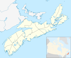 Neil's Harbour Location of Neil's Harbour, Nova Scotia | |
| Coordinates: 46°48′21″N 60°19′12″W / 46.80583°N 60.32000°WCoordinates: 46°48′21″N 60°19′12″W / 46.80583°N 60.32000°W | |
| Country | |
| Province | |
| Municipality | Municipality of the County of Victoria |
| Time zone | UTC−4 (AST) |
| • Summer (DST) | UTC−3 (ADT) |
| Canadian Postal Code | B0C 1N0 |
| Area code(s) | 902 |
| Telephone Exchange | 336 |
| NTS Map | 011K16 |
| GNBC Code | CBBFE |
Neil's Harbour is an unincorporated area in the Municipality of the County of Victoria, Cape Breton Island, Nova Scotia, Canada.
Artifacts indicate that it have been originally settled by the Acadians. It is named after Neil McLennan.

Victoria Co-Op Fisheries Ltd., Neil's Harbour's largest employer which is located in neighbouring New Haven.
The town has an operating Anglican church and a non-operational Presbyterian church.
The population is approximately 300 permanent residents. There are a few cottages, but mostly there are local residents who work in the lobster/crab and fishing industry.
The first school was constructed in 1878. The Cabot Education Centre lies on the west side of the village on the Cabot Trail.
Subdivisions of Nova Scotia | |
|---|---|
| Counties | |
| County municipalities | |
| Regional municipalities | |
| District municipalities | |
| Towns | |
| Villages | |
| Economic regions | |
| Lists | |
| |
Categories:
- Places of local interest needing cleanup
- Communities in Victoria County, Nova Scotia
- General Service Areas in Nova Scotia