Oltedalsvatnet
| Oltedalsvatnet | |
|---|---|
 | |
 Oltedalsvatnet Location of the lake | |
| Location | Gjesdal, Rogaland |
| Coordinates | 58°48′53″N 6°00′48″E / 58.8146°N 6.0133°ECoordinates: 58°48′53″N 6°00′48″E / 58.8146°N 6.0133°E |
| Primary outflows | Oltedalsåna river |
| Basin countries | Norway |
| Max. length | 4 kilometres (2.5 mi) |
| Max. width | 1.5 kilometres (0.93 mi) |
| Surface area | 3.12 km2 (1.20 sq mi) |
| Water volume | 28,800,000 m3 (23,300 acre⋅ft; 37,700,000 cu yd) |
| Shore length1 | 16.61 kilometres (10.32 mi) |
| Surface elevation | 101.5 to 112.5 metres (333 to 369 ft) |
| References | NVE |
| 1 Shore length is not a well-defined measure. | |


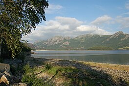
Oltedalsvatnet is a lake in the municipality of Gjesdal in Rogaland county, Norway.[1] The 3.12-square-kilometre (1.20 sq mi) lake lies just south of the village of Oltedal. It is a reservoir along the river Oltedalsåna that is used to store water for the . The lake sits at an elevation of 101.5 to 112.5 metres (333 to 369 ft) and it holds about 28,800,000 cubic metres (23,300 acre⋅ft; 37,700,000 cu yd).[2]
See also[]
- List of lakes in Norway
References[]
- ^ "Oltedalsvatnet, Gjesdal (Rogaland)" (in Norwegian). yr.no. Retrieved 2016-03-07.
- ^ "Search Oltedalsvatnet > Vannkraft > Magasin > Details" (in Norwegian). NVE Atlas. Archived from the original on 2015-06-26.
This Rogaland location article is a stub. You can help Wikipedia by . |
Categories:
- Gjesdal
- Lakes of Rogaland
- Rogaland geography stubs