Park County, Wyoming
Park County | |
|---|---|
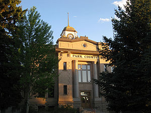 Park County Courthouse in Cody | |
 Flag | |
 Location within the U.S. state of Wyoming | |
 Wyoming's location within the U.S. | |
| Coordinates: 44°29′N 109°34′W / 44.49°N 109.56°W | |
| Country | |
| State | |
| Founded | February 15, 1909 (established) 1911 (organized) |
| Named for | Yellowstone National Park |
| Seat | Cody |
| Largest city | Cody |
| Area | |
| • Total | 6,967 sq mi (18,040 km2) |
| • Land | 6,942 sq mi (17,980 km2) |
| • Water | 25 sq mi (60 km2) 0.4%% |
| Population (2010) | |
| • Total | 28,205 |
| • Estimate (2019) | 29,194 |
| • Density | 4.0/sq mi (1.6/km2) |
| Time zone | UTC−7 (Mountain) |
| • Summer (DST) | UTC−6 (MDT) |
| Congressional district | At-large |
| Website | parkcounty-wy |

Park County is a county in the U.S. state of Wyoming. As of the 2010 United States Census, the population was 28,205.[1] The county seat is Cody.[2]
Park County is a mecca for tourists. The county has over 53 percent of Yellowstone National Park's land area.[3] Many attractions abound, including the Buffalo Bill Historical Center, the Cody Stampede Rodeo, the , and the western museum, .
History[]
Wyoming gained separate territorial status in 1868. Before that, most of the state's area was included in either Laramie County (part of the Dakota Territory) or as unorganized territory within the Dakota Territory. Wyoming Territory was established on July 25, 1868, at which time Laramie County was assigned to this jurisdiction. The area now known as Park County was established as Carter County, then Sweetwater County. In 1884 it was assigned to Fremont County; this continued until 1896, when it was assigned to Big Horn County.
Wyoming achieved statehood in 1890. The area of present-day Park Continued as part of Big Horn County until 1909, when Park County was authorized. The county governing structure was put in place during 1911;[4] a courthouse was constructed 1911–1912. An addition to the building was completed in 1983, and the complete building was restored in 1985. [5] The county was named for Yellowstone National Park which is mostly within the limits of Park County.[6]
Immigrants from Ireland and Germany settled in what would become Park County in the 1870s.[7] Immigrants from England were the largest immigrant group in Park County in the late 1800s and early 1900s.[8] In 1911 when the county was organized the largest population group in the county were first generation English immigrants and their Wyoming-born children. Many English immigrants who had settled in Wyoming and become American citizens remained connected to England, many of the children of these English immigrants who had been born and raised in Wyoming joined the Canadian military in order to fight alongside Britain during World War I, and subsequently, when America joined the war many volunteered to join the United States military before the U.S. officially instituted a draft.[9]
In 1913, Hot Springs County was created from portions of Park County, Big Horn County, and Fremont County. Park County also had minor boundary adjustments in 1929 and 1931, but otherwise its boundaries have remained unchanged.
Geography[]
Much of Park County is held under state or federal control. Most of the Shoshone National Forest, the first national forest, and a portion of Yellowstone National Park, the first national park, fall within Park County boundaries. Three rivers flow through Park County: the Greybull and Shoshone Rivers which are tributaries to the Big Horn River, and the Clark's Fork River which flows into the Yellowstone River.[5]
According to the US Census Bureau, the county has a total area of 6,967 square miles (18,040 km2), of which 6,942 square miles (17,980 km2) is land and 25 square miles (65 km2) (0.4%) is water.[10]
Adjacent counties[]
- Park County, Montana – north
- Carbon County, Montana – northeast
- Big Horn County – east
- Washakie County – east-southeast
- Hot Springs County – southeast
- Fremont County – south
- Teton County – southwest
- Gallatin County, Montana – northwest
National protected areas[]
- Bridger-Teton National Forest (part)
- Shoshone National Forest (part)
- Yellowstone National Park (part)
Major highways[]
 U.S. Highway 14
 U.S. Highway 14A
 U.S. Highway 16
 U.S. Highway 20
 U.S. Highway 191
 U.S. Highway 212
 U.S. Highway 287
 Wyoming Highway 120
 Wyoming Highway 296
Demographics[]
| Historical population | |||
|---|---|---|---|
| Census | Pop. | %± | |
| 1910 | 4,909 | — | |
| 1920 | 7,298 | 48.7% | |
| 1930 | 8,207 | 12.5% | |
| 1940 | 10,976 | 33.7% | |
| 1950 | 15,182 | 38.3% | |
| 1960 | 16,874 | 11.1% | |
| 1970 | 17,752 | 5.2% | |
| 1980 | 21,639 | 21.9% | |
| 1990 | 23,178 | 7.1% | |
| 2000 | 25,786 | 11.3% | |
| 2010 | 28,205 | 9.4% | |
| 2020 (est.) | 29,331 | [11] | 4.0% |
| US Decennial Census[12] 1870–2000[13] 2010–2016[1] | |||
2000 census[]
As of the 2000 United States Census,[14] there were 25,786 people, 10,312 households, and 7,094 families in the county. The population density was 4 people per square mile (1/km2). There were 11,869 housing units at an average density of 2 per square mile (1/km2). The racial makeup of the county was 96.46% White, 0.09% Black or African American, 0.47% Native American, 0.44% Asian, 0.05% Pacific Islander, 1.41% from other races, and 1.08% from two or more races. 3.72% of the population were Hispanic or Latino of any race. 26.3% were of German and 13.3% English ancestry.
There were 10,312 households, out of which 30.10% had children under the age of 18 living with them, 58.90% were married couples living together, 7.10% had a female householder with no husband present, and 31.20% were non-families. 26.20% of all households were made up of individuals, and 10.00% had someone living alone who was 65 years of age or older. The average household size was 2.42 and the average family size was 2.92.
The county population contained 24.40% under the age of 18, 9.10% from 18 to 24, 25.20% from 25 to 44, 26.70% from 45 to 64, and 14.50% who were 65 years of age or older. The median age was 40 years. For every 100 females there were 95.00 males. For every 100 females age 18 and over, there were 93.10 males.
The median income for a household in the county was $35,829, and the median income for a family was $41,406. Males had a median income of $33,452 versus $20,500 for females. The per capita income for the county was $18,020. About 8.40% of families and 12.70% of the population were below the poverty line, including 16.60% of those under age 18 and 8.30% of those age 65 or over.
2010 census[]
As of the 2010 United States Census, there were 28,205 people, 11,885 households, and 7,777 families in the county.[15] The population density was 4.1 inhabitants per square mile (1.6/km2). There were 13,562 housing units at an average density of 2.0 per square mile (0.77/km2).[16] The racial makeup of the county was 95.6% white, 0.6% Asian, 0.6% American Indian, 0.2% black or African American, 0.1% Pacific islander, 1.4% from other races, and 1.6% from two or more races. Those of Hispanic or Latino origin made up 4.8% of the population.[15] In terms of ancestry, 31.7% were German, 16.3% were English, 15.4% were Irish, and 6.3% were American.[17]
Of the 11,885 households, 26.1% had children under the age of 18 living with them, 54.9% were married couples living together, 7.2% had a female householder with no husband present, 34.6% were non-families, and 28.5% of all households were made up of individuals. The average household size was 2.29 and the average family size was 2.81. The median age was 43.6 years.[15]
The median income for a household in the county was $46,637 and the median income for a family was $58,297. Males had a median income of $40,036 versus $27,450 for females. The per capita income for the county was $26,203. About 5.5% of families and 9.0% of the population were below the poverty line, including 14.2% of those under age 18 and 6.4% of those age 65 or over.[18]
Communities[]
Cities[]
Towns[]
Census-designated places[]
Unincorporated communities[]
Former communities[]
Politics[]
Like almost all of Wyoming, Park County is overwhelmingly Republican. It was most recently carried by a Democrat in 1964 when Lyndon Johnson beat Barry Goldwater by forty-seven votes. Since then, no Democrat has passed thirty-one percent of the county’s vote.
See also[]
References[]
- ^ Jump up to: a b "State & County QuickFacts". US Census Bureau. Archived from the original on June 6, 2011. Retrieved January 25, 2014.
- ^ "Find a County". National Association of Counties. Archived from the original on May 31, 2011. Retrieved June 7, 2011.
- ^ "Census 2000 Summary File 1 (SF 1) 100-Percent Data ." US Census Bureau.
- ^ Long, John H., ed. (2004). "Wyoming: Individual County Chronologies". Wyoming Atlas of Historical County Boundaries. The Newberry Library. Retrieved January 11, 2019.
- ^ Jump up to: a b History of Park County (accessed 11 January 2019)
- ^ Urbanek, Mae (1988). Wyoming Place Names. Missoula MT: Mountain Press Pub. Co. ISBN 0-87842-204-8.
- ^ Wyoming: A Source Book by Roy Allen Jordan and Brett DeBoer; University Press of Colorado, 1996 - pg. 56
- ^ Peopling the High Plains: Wyoming's European Heritage by Gordon Olaf Hendrickson, pg. 2
- ^ Peopling the High Plains: Wyoming's European Heritage by Gordon Olaf Hendrickson, pg. 27
- ^ "2010 Census Gazetteer Files". US Census Bureau. August 22, 2012. Retrieved August 18, 2015.
- ^ "Population and Housing Unit Estimates". Retrieved September 5, 2021.
- ^ "US Decennial Census". US Census Bureau. Retrieved August 18, 2015.
- ^ "Historical Decennial Census Population for Wyoming Counties, Cities, and Towns". Wyoming Department of Administration & Information, Division of Economic Analysis. Retrieved January 25, 2014.
- ^ "U.S. Census website". US Census Bureau. Retrieved May 14, 2011.
- ^ Jump up to: a b c "Profile of General Population and Housing Characteristics: 2010 Demographic Profile Data". US Census Bureau. Archived from the original on February 13, 2020. Retrieved January 12, 2016.
- ^ "Population, Housing Units, Area, and Density: 2010 - County". US Census Bureau. Archived from the original on February 13, 2020. Retrieved January 12, 2016.
- ^ "Selected Social Characteristics in the US – 2006-2010 American Community Survey 5-Year Estimates". US Census Bureau. Archived from the original on February 13, 2020. Retrieved January 12, 2016.
- ^ "Selected Economic Characteristics – 2006-2010 American Community Survey 5-Year Estimates". US Census Bureau. Archived from the original on February 13, 2020. Retrieved January 12, 2016.
- ^ Badger Basin Google Maps (accessed 11 January 2019)
- ^ Canyon Village WY Google Maps (accessed 11 January 2019)
- ^ Devils Den WY Google Maps (accessed 11 January 2019)
- ^ Dry Creek WY Google Maps (accessed 11 January 2019)
- ^ Dumbell WY Google Maps (accessed 11 January 2019)
- ^ Elk Basin WY Google Maps (accessed 11 January 2019)
- ^ Fossil Forest WY Google Maps (accessed 11 January 2019)
- ^ Kirwin WY Google Maps (accessed 11 January 2019)
- ^ Pahaska Tepee WY Google Maps (accessed 11 January 2019)
- ^ Tower Junction WY Google Maps (accessed 11 January 2019)
- ^ Willwood WY Google Maps (accessed 11 January 2019)
- ^ Leip, David. "Atlas of US Presidential Elections". uselectionatlas.org. Retrieved April 5, 2018.
External links[]
| Wikimedia Commons has media related to Park County, Wyoming. |
- Buffalo Bill's Cody/Yellowstone Country - Official Web Site of the Park County Travel Council
- Cody Chamber of Commerce
- Park County Archives
| show Places adjacent to Park County, Wyoming |
|---|
| show Municipalities and communities of Park County, Wyoming, United States |
|---|


- Wyoming counties
- Park County, Wyoming
- 1911 establishments in Wyoming
- Populated places established in 1911