[3] Name on the Register
Image
Date listed[4]
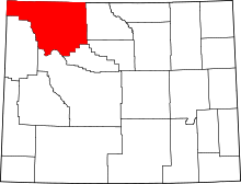
Location
City or town
Description
1
Absaroka Mountain Lodge
October 30, 2003 (#03001105 ) 1231 North Fork Highway 44°27′26″N 109°47′25″W / 44.457222°N 109.790278°W / 44.457222; -109.790278 (Absaroka Mountain Lodge ) Cody
2
Anderson Lodge
September 14, 1987 (#87001548 ) Greybull Ranger District, Shoshone National Forest 44°06′06″N 109°25′56″W / 44.101667°N 109.432222°W / 44.101667; -109.432222 (Anderson Lodge ) Meeteetse
3
Quintin Blair House Upload image September 27, 1991 (#91000998 ) 5588 Greybull Highway 44°30′34″N 109°00′05″W / 44.509334°N 109.001307°W / 44.509334; -109.001307 (Quintin Blair House ) Cody
4
Buffalo Bill Boyhood Home
June 5, 1975 (#75001906 ) 720 Sheridan Ave. 44°31′27″N 109°04′25″W / 44.5241715°N 109.0737033°W / 44.5241715; -109.0737033 (Buffalo Bill Boyhood Home ) Cody
5
Buffalo Bill Dam
August 12, 1971 (#71000890 ) 7 miles west of Cody 44°30′05″N 109°10′57″W / 44.501389°N 109.1825°W / 44.501389; -109.1825 (Buffalo Bill Dam ) Cody
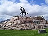
6
Buffalo Bill Statue
December 31, 1974 (#74002319 ) 720 Sheridan Ave. 44°31′33″N 109°04′26″W / 44.525833°N 109.073889°W / 44.525833; -109.073889 (Buffalo Bill Statue ) Cody
7
Clay Butte Lookout
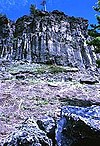
January 8, 2014 (#13001065 ) Approx. 1/2 mi. N. of jct. of US 212 and FS Rd. 142 44°56′40″N 109°37′36″W / 44.944392°N 109.626573°W / 44.944392; -109.626573 (Clay Butte Lookout ) Clark vicinityFire lookout tower built 1941-43, started by the Civilian Conservation Corps
8
Colter's Hell
August 14, 1973 (#73001937 ) West of Cody on U.S. Route 14 44°30′53″N 109°07′02″W / 44.514722°N 109.117222°W / 44.514722; -109.117222 (Colter's Hell ) Cody A square mile of steam vents and hot springs on the Shoshone River . When John Colter saw it in 1807, it had active geysers. His account of that visit was the first description by a white man of a place in Wyoming.[5]
9
Dead Indian Campsite Upload image May 3, 1974 (#74002030 ) Sunlight Basin Road[6] Cody
10
Downtown Cody Historic District
August 15, 1983 (#83003361 ) 1155 to 1313 and 1192 to 1286 Sheridan Ave. 44°31′34″N 109°04′21″W / 44.526111°N 109.0725°W / 44.526111; -109.0725 (Downtown Cody Historic District ) Cody
11
Elephant Head Lodge Upload image October 30, 2003 (#03001107 ) 1170 North Fork Highway 44°27′18″N 109°48′13″W / 44.455°N 109.803611°W / 44.455; -109.803611 (Elephant Head Lodge ) Cody
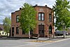
12
First National Bank of Meeteetse
September 5, 1990 (#90001388 ) 1033 Park Ave. 44°09′25″N 108°52′21″W / 44.157051°N 108.872433°W / 44.157051; -108.872433 (First National Bank of Meeteetse ) Meeteetse
13
Fort Yellowstone
July 31, 2003 (#03001032 ) Mammoth Hot Springs and Norris, Wyoming; Gardiner, Montana, near Buffalo Lake, Idaho 44°58′30″N 110°41′53″W / 44.975°N 110.698056°W / 44.975; -110.698056 (Fort Yellowstone ) Mammoth Hot Springs
14
Goff Creek Lodge Upload image October 30, 2003 (#03001108 ) 995 E. Yellowstone Highway 44°27′19″N 109°50′12″W / 44.455278°N 109.836667°W / 44.455278; -109.836667 (Goff Creek Lodge ) Cody
15
Grand Loop Road Historic District
December 23, 2003 (#03001345 ) Grand Loop Rd. 44°38′16″N 110°36′54″W / 44.637778°N 110.615°W / 44.637778; -110.615 (Grand Loop Road Historic District ) Yellowstone National Park
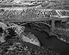
16
Hayden Arch Bridge
February 22, 1985 (#85000430 ) Old US Routes 14 /16 (Cody Yellowstone Highway) 44°30′37″N 109°08′48″W / 44.510278°N 109.146667°W / 44.510278; -109.146667 (Hayden Arch Bridge ) Cody
17
Heart Mountain Relocation Center
December 19, 1985 (#85003167 ) ½ mile from Wyoming Alt. 14 between Cody and Powell/1500 Road 19 44°40′14″N 108°56′35″W / 44.670556°N 108.943056°W / 44.670556; -108.943056 (Heart Mountain Relocation Center ) Ralston
18
Horner Site Upload image October 15, 1966 (#66000758 ) On a bluff overlooking the confluence of Sage Creek and the Shoshone River , 5 miles (8.0 km) east of Cody[7] 44°33′21″N 108°59′39″W / 44.5558°N 108.9942°W / 44.5558; -108.9942 (Horner Site ) Cody
19
Irma Hotel
April 3, 1973 (#73001936 ) 1192 Sheridan Ave. 44°31′35″N 109°03′26″W / 44.526389°N 109.057222°W / 44.526389; -109.057222 (Irma Hotel ) Cody
20
Lamar Buffalo Ranch
December 7, 1982 (#82001835 ) East of Mammoth Hot Springs on Northeast Entrance Rd. 44°53′32″N 110°14′23″W / 44.892222°N 110.239722°W / 44.892222; -110.239722 (Lamar Buffalo Ranch ) Mammoth Hot Springs
21
Mammoth Hot Springs Historic District
March 20, 2002 (#02000257 ) North Entrance Rd. and Mammoth-Norris Rd. 44°58′37″N 110°41′52″W / 44.976944°N 110.697778°W / 44.976944; -110.697778 (Mammoth Hot Springs Historic District ) Yellowstone National Park
22
Mummy Cave
February 18, 1981 (#81000611 ) U.S. Routes 14 /16 /20 near the eastern entrance of Yellowstone National Park [8] 44°27′39″N 109°44′10″W / 44.4607°N 109.736°W / 44.4607; -109.736 (Mummy Cave ) Cody
23
Norris Museum/Norris Comfort Station
July 21, 1983 (#83003362 ) Grand Loop Rd. 44°43′34″N 110°42′21″W / 44.726111°N 110.705833°W / 44.726111; -110.705833 (Norris Museum/Norris Comfort Station ) Yellowstone National Park
24
Norris, Madison, and Fishing Bridge Museums
May 28, 1987 (#87001445 ) Norris Geyser Basin, Madison Junction, and Fishing Bridge 44°38′38″N 110°38′49″W / 44.643889°N 110.646944°W / 44.643889; -110.646944 (Norris, Madison, and Fishing Bridge Museums ) Yellowstone National Park
25
North Entrance Road Historic District
May 22, 2002 (#02000530 ) Yellowstone National Park 45°00′24″N 110°41′58″W / 45.006667°N 110.699444°W / 45.006667; -110.699444 (North Entrance Road Historic District ) Yellowstone National Park
26
Obsidian Cliff
June 19, 1996 (#96000973 ) Approximately 13 miles south of Mammoth; eastern side of U.S. Route 89 , south of Obsidian Cliff Kiosk 44°48′28″N 110°41′52″W / 44.807778°N 110.697778°W / 44.807778; -110.697778 (Obsidian Cliff ) Mammoth
27
Obsidian Cliff Kiosk
July 9, 1982 (#82001719 ) Yellowstone National Park 44°49′20″N 110°44′02″W / 44.822222°N 110.733889°W / 44.822222; -110.733889 (Obsidian Cliff Kiosk ) Mammoth
28
Pagoda Creek Upload image December 22, 2017 (#100001914 ) Address Restricted Wapiti
29
Pahaska Tepee
March 20, 1973 (#73001938 ) 2 miles east of eastern entrance to Yellowstone National Park on U.S. Route 14 44°30′10″N 109°57′42″W / 44.502778°N 109.961667°W / 44.502778; -109.961667 (Pahaska Tepee ) Cody
30
Pioneer School
October 5, 1993 (#93001011 ) County Road 1-AG north of Badger Basin 44°58′23″N 109°05′00″W / 44.973056°N 109.083333°W / 44.973056; -109.083333 (Pioneer School ) Clark
31
Ralston Community Clubhouse
July 23, 1998 (#98000907 ) 969 Carbon St. 44°43′11″N 108°52′05″W / 44.719646°N 108.867991°W / 44.719646; -108.867991 (Ralston Community Clubhouse ) Ralston
32
Red Lodge-Cooke City Approach Road Historic District
May 8, 2014 (#14000219 ) US 212 44°56′31″N 109°35′47″W / 44.941823°N 109.596287°W / 44.941823; -109.596287 (Red Lodge-Cooke City Approach Road Historic District ) Red Lodge Extends into Carbon County, Montana and Park County, Montana
33
Red Star Lodge and Sawmill Upload image October 30, 2003 (#03001106 ) 349 Yellowstone Highway 44°29′49″N 109°56′04″W / 44.496944°N 109.934444°W / 44.496944; -109.934444 (Red Star Lodge and Sawmill ) Cody
34
Roosevelt Lodge Historic District
April 4, 1983 (#83003363 ) Grand Loop Rd. 44°54′47″N 110°24′56″W / 44.913056°N 110.415556°W / 44.913056; -110.415556 (Roosevelt Lodge Historic District ) Yellowstone National Park
35
Stock Center
January 1, 1976 (#76001960 ) 836 Sheridan Ave. 44°31′31″N 109°04′11″W / 44.525278°N 109.069722°W / 44.525278; -109.069722 (Stock Center ) Cody
36
Paul Stock House
January 27, 2000 (#99001727 ) 1300 Sunset Dr. 44°31′24″N 109°04′50″W / 44.523333°N 109.080556°W / 44.523333; -109.080556 (Paul Stock House ) Cody
37
T E Ranch Headquarters Upload image April 3, 1973 (#73001939 ) 30 miles southwest of Cody on South Fork Rd. 44°16′53″N 109°29′35″W / 44.281389°N 109.493056°W / 44.281389; -109.493056 (T E Ranch Headquarters ) Cody
38
US Post Office-Powell Main
May 22, 1987 (#87000787 ) 270 N. Bent St. 44°45′19″N 108°45′27″W / 44.755278°N 108.7575°W / 44.755278; -108.7575 (US Post Office-Powell Main ) Powell
39
US Post Office-Yellowstone Main
May 19, 1987 (#87000789 ) Mammoth, off Grand Loop Rd. 44°58′37″N 110°41′52″W / 44.976944°N 110.697778°W / 44.976944; -110.697778 (US Post Office-Yellowstone Main ) Yellowstone National Park
40
UXU Ranch Upload image May 24, 2003 (#03000581 ) 1710 N. Fork Highway, Shoshone National Forest 44°27′18″N 109°42′53″W / 44.455°N 109.714735°W / 44.455; -109.714735 (UXU Ranch ) Wapiti
41
Wapiti Ranger Station
October 15, 1966 (#66000759 ) Shoshone National Forest 44°27′57″N 109°36′58″W / 44.465833°N 109.616111°W / 44.465833; -109.616111 (Wapiti Ranger Station ) Wapiti