[2] Name on the Register
Image
Date listed[3]
Location
City or town
Description
1
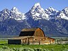
4 Lazy F Dude Ranch
April 23, 1990 (#90000611 ) Off Teton Park Rd. 43°40′03″N 110°42′27″W / 43.6675°N 110.7075°W / 43.6675; -110.7075 (4 Lazy F Dude Ranch ) Moose
2
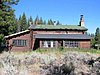
AMK Ranch
April 23, 1990 (#90000615 ) Off U.S. Routes 27 /89 43°56′20″N 110°38′30″W / 43.9389°N 110.6417°W / 43.9389; -110.6417 (AMK Ranch ) Moran
3
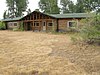
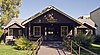
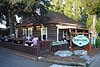
Alpenhof Lodge
August 9, 2016 (#16000520 ) 3255 W. Village Dr. 43°35′16″N 110°49′34″W / 43.5879°N 110.8261°W / 43.5879; -110.8261 (Alpenhof Lodge ) Teton Village
4
Bar B C Dude Ranch
April 23, 1990 (#90000624 ) Off Teton Park Rd. 43°41′42″N 110°41′42″W / 43.695°N 110.695°W / 43.695; -110.695 (Bar B C Dude Ranch ) Moose
5
The Brinkerhoff
April 23, 1990 (#90000622 ) Teton Park Rd. 43°51′03″N 110°35′35″W / 43.8508°N 110.5931°W / 43.8508; -110.5931 (The Brinkerhoff ) Moose
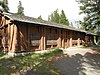
6
Cascade Canyon Barn
August 18, 1998 (#98001023 ) Cascade Canyon 5 miles upstream from Jenny Lake 43°46′05″N 110°49′22″W / 43.7681°N 110.8228°W / 43.7681; -110.8228 (Cascade Canyon Barn ) Moose
7
Andy Chambers Ranch Historic District
April 23, 1990 (#90000623 ) Mormon Row east of Moose 43°39′29″N 110°39′41″W / 43.6581°N 110.6614°W / 43.6581; -110.6614 (Andy Chambers Ranch Historic District ) Moose
8
Chapel of the Transfiguration
April 10, 1980 (#80004055 ) Grand Teton National Park 43°39′37″N 110°42′52″W / 43.6603°N 110.7144°W / 43.6603; -110.7144 (Chapel of the Transfiguration ) Moose
9
Cunningham Cabin
October 2, 1973 (#73000225 ) Northeast of Moose off U.S. Routes 26 /89 /187 in Grand Teton National Park 43°46′44″N 110°33′28″W / 43.7789°N 110.5578°W / 43.7789; -110.5578 (Cunningham Cabin ) Moose
10
Upload image April 27, 2021 (#100005445 ) 1 Kinky Creek Rd. 43°24′44″N 110°09′41″W / 43.4123°N 110.1613°W / 43.4123; -110.1613 (Darwin Ranch ) Cora vicinity
11
Death Canyon Barn
August 25, 1998 (#98001024 ) 5 miles northwest of Phelps Lake near Alaska Basin 43°39′53″N 110°49′45″W / 43.6647°N 110.8292°W / 43.6647; -110.8292 (Death Canyon Barn ) Moose
12
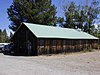
Double Diamond Dude Ranch Dining Hall
August 18, 1998 (#98001028 ) 5 miles north of Moose, western side of Teton Park Rd. and Cottonwood Creek 43°42′07″N 110°44′05″W / 43.7019°N 110.7347°W / 43.7019; -110.7347 (Double Diamond Dude Ranch Dining Hall ) Moose
13
Flat Creek Ranch Upload image December 31, 2001 (#01001428 ) Approximately 12 miles east and north 43°31′40″N 110°32′33″W / 43.5278°N 110.5425°W / 43.5278; -110.5425 (Flat Creek Ranch ) Jackson
14
Game Creek Upload image December 2, 2019 (#100004708 ) Address Restricted Jackson vicinity
15
Gap Puche Cabin Upload image June 18, 1990 (#90000889 ) Gros Ventre R. Rd. east of Grizzly Lake 43°36′32″N 110°27′15″W / 43.6089°N 110.4542°W / 43.6089; -110.4542 (Gap Puche Cabin ) Jackson
16
George Washington Memorial Park
December 5, 2003 (#03001250 ) Between Cache, Center, Broadway, and Deloney 43°28′48″N 110°45′42″W / 43.480°N 110.7617°W / 43.480; -110.7617 (George Washington Memorial Park ) Jackson
17
Hardeman Barns
April 28, 2015 (#15000190 ) 5450 W. WY 22 43°29′52″N 110°52′12″W / 43.4978°N 110.8699°W / 43.4978; -110.8699 (Hardeman Barns ) Wilson
18
Highlands Historic District
August 19, 1998 (#98001029 ) 5 miles north of park headquarters, ¼ mile west of Teton Park Rd. 43°42′32″N 110°43′45″W / 43.7089°N 110.7292°W / 43.7089; -110.7292 (Highlands Historic District ) Moose
19
Huckleberry Mountain Fire Lookout Upload image July 8, 1983 (#83003365 ) Off U.S. Routes 89 /287 44°04′57″N 110°35′50″W / 44.0825°N 110.5972°W / 44.0825; -110.5972 (Huckleberry Mountain Fire Lookout ) Teton National Forest
20
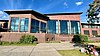
Huff Memorial Library
December 5, 2003 (#03001253 ) 320 S. King St. 43°28′41″N 110°45′37″W / 43.4781°N 110.7603°W / 43.4781; -110.7603 (Huff Memorial Library ) Jackson
21
Hunter Hereford Ranch Historic District
August 24, 1998 (#98001031 ) Southeastern corner of park, south of Shadow Mountain along Aspen Ridge 43°40′33″N 110°36′36″W / 43.6759°N 110.6099°W / 43.6759; -110.6099 (Hunter Hereford Ranch Historic District ) Moose
22
Jackson Hole American Legion Post No. 43
September 12, 2003 (#03000939 ) 182 N. Cache 43°28′55″N 110°45′40″W / 43.4819°N 110.7611°W / 43.4819; -110.7611 (Jackson Hole American Legion Post No. 43 ) Jackson
23
Jackson Lake Lodge
July 31, 2003 (#03001039 ) Teton Park Road 43°52′50″N 110°34′32″W / 43.880556°N 110.575556°W / 43.880556; -110.575556 (Jackson Lake Lodge ) Moran
24
Jackson Lake Ranger Station
April 23, 1990 (#90000620 ) Off Teton Park Rd. 43°52′18″N 110°34′14″W / 43.871667°N 110.570556°W / 43.871667; -110.570556 (Jackson Lake Ranger Station ) Moose
25
Jenny Lake Boat Concession Facilities
August 24, 1998 (#98001032 ) Southern end of Jenny Lake 43°45′04″N 110°43′31″W / 43.751111°N 110.725278°W / 43.751111; -110.725278 (Jenny Lake Boat Concession Facilities ) Moose
26
Jenny Lake CCC Camp NP-4
July 7, 2006 (#98001033 ) ¼ mile south of Jenny Lake on the western side of Cottonwood Creek 43°44′58″N 110°43′28″W / 43.749444°N 110.724444°W / 43.749444; -110.724444 (Jenny Lake CCC Camp NP-4 ) Moose
27
Jenny Lake Ranger Station Historic District
April 23, 1990 (#90000610 ) Jenny Lake Rd. 43°45′13″N 110°43′19″W / 43.753611°N 110.721944°W / 43.753611; -110.721944 (Jenny Lake Ranger Station Historic District ) Moose
28
Kimmel Kabins
April 23, 1990 (#90000612 ) Off Teton Park Rd. 43°44′38″N 110°43′38″W / 43.743889°N 110.727222°W / 43.743889; -110.727222 (Kimmel Kabins ) Moose
29
Lake Fish Hatchery Historic District
December 7, 1982 (#85001416 ) Yellowstone National Park 44°32′58″N 110°24′13″W / 44.549444°N 110.403611°W / 44.549444; -110.403611 (Lake Fish Hatchery Historic District )
30
Lake Hotel
May 16, 1991 (#91000637 ) Northwestern shore of Lake Yellowstone 44°32′59″N 110°24′00″W / 44.549722°N 110.4°W / 44.549722; -110.4 (Lake Hotel ) Yellowstone National Park
31
Leigh Lake Ranger Patrol Cabin
April 23, 1990 (#90000618 ) Off Teton Park Teton Rd. at Lehigh Lake 43°49′36″N 110°44′16″W / 43.826667°N 110.737778°W / 43.826667; -110.737778 (Leigh Lake Ranger Patrol Cabin ) Moose
32
Geraldine Lucas Homestead-Fabian Place Historic District
August 24, 1998 (#98001034 ) 4.5 miles north of Moose 43°43′16″N 110°44′03″W / 43.721111°N 110.734167°W / 43.721111; -110.734167 (Geraldine Lucas Homestead-Fabian Place Historic District ) Moose
33
Madison Museum
July 9, 1982 (#82001720 ) Yellowstone National Park 44°38′32″N 110°51′41″W / 44.642222°N 110.861389°W / 44.642222; -110.861389 (Madison Museum )
34
Manges Cabin
August 19, 1998 (#98001035 ) Southern end of park southeast of Taggart Lake 43°41′54″N 110°43′59″W / 43.698333°N 110.733056°W / 43.698333; -110.733056 (Manges Cabin ) Moose
35
Menor's Ferry
April 16, 1969 (#69000016 ) Across the Snake River just above park headquarters, Grand Teton National Park 43°39′30″N 110°42′29″W / 43.658333°N 110.708056°W / 43.658333; -110.708056 (Menor's Ferry ) Moose
36
Miller Cabin
April 16, 1969 (#69000195 ) 1 mile northeast of Jackson 43°29′20″N 110°44′16″W / 43.488889°N 110.737778°W / 43.488889; -110.737778 (Miller Cabin ) Jackson
37
Grace and Robert Miller Ranch
November 11, 2002 (#01001454 ) 1 mile northeast of Jackson 43°29′22″N 110°44′12″W / 43.489444°N 110.736667°W / 43.489444; -110.736667 (Grace and Robert Miller Ranch ) Jackson
38
Moose Entrance Kiosk
April 23, 1990 (#90000619 ) Teton Park Rd. 43°39′30″N 110°43′09″W / 43.658333°N 110.719167°W / 43.658333; -110.719167 (Moose Entrance Kiosk ) Moose
39
Moran Bay Patrol Cabin Upload image August 25, 1998 (#98001037 ) Northern bank of Moran Bay on Jackson Lake 43°39′53″N 110°49′45″W / 43.664722°N 110.829167°W / 43.664722; -110.829167 (Moran Bay Patrol Cabin ) Moose Destroyed by forest fire in 2000[4]
40
Mormon Row Historic District
June 5, 1997 (#97000495 ) Roughly east of U.S. Routes 26 /89 /187 from Antelope Flats to Grand Teton National Park -Teton National Forest border 43°39′24″N 110°37′06″W / 43.656667°N 110.618333°W / 43.656667; -110.618333 (Mormon Row Historic District ) Moose
41
Murie Ranch Historic District
August 24, 1998 (#98001039 ) ½ mile southwest of park headquarters 43°39′02″N 110°43′37″W / 43.650556°N 110.726944°W / 43.650556; -110.726944 (Murie Ranch Historic District ) Moose
42
Murie Residence
April 23, 1990 (#90000616 ) Off Moose Wilson Rd. 43°39′00″N 110°43′37″W / 43.65°N 110.726944°W / 43.65; -110.726944 (Murie Residence ) Moose
43
Norris, Madison, and Fishing Bridge Museums
May 28, 1987 (#87001445 ) Norris Geyser Basin, Madison Junction, and Fishing Bridge 44°38′38″N 110°38′49″W / 44.643889°N 110.646944°W / 44.643889; -110.646944 (Norris, Madison, and Fishing Bridge Museums ) Yellowstone National Park
44
Old Administrative Area Historic District
April 23, 1990 (#90000621 ) Off Teton Park Rd. 43°41′10″N 110°44′08″W / 43.686111°N 110.735556°W / 43.686111; -110.735556 (Old Administrative Area Historic District ) Moose
45
Old Faithful Historic District
December 7, 1982 (#82001839 ) Both sides of Grand Loop Rd. at Old Faithful Geyser 44°27′13″N 110°50′09″W / 44.453611°N 110.835833°W / 44.453611; -110.835833 (Old Faithful Historic District ) Yellowstone National Park
46
Old Faithful Inn
July 23, 1973 (#73000226 ) West of West Thumb at Old Faithful Geyser on Grand Loop Rd. 44°27′35″N 110°49′49″W / 44.459722°N 110.830278°W / 44.459722; -110.830278 (Old Faithful Inn ) West Thumb
47
Queen's Laundry Bath House
July 25, 2001 (#01000790 ) Sentinel Meadows, Lower Geyser Basin 44°33′50″N 110°52′11″W / 44.563889°N 110.869722°W / 44.563889; -110.869722 (Queen's Laundry Bath House ) Yellowstone National Park
48
Ramshorn Dude Ranch Lodge
August 19, 1998 (#98001041 ) Southeastern corner of park, 2.5 miles northwest of Kelly 43°40′11″N 110°35′46″W / 43.669722°N 110.596111°W / 43.669722; -110.596111 (Ramshorn Dude Ranch Lodge ) Moose
49
Rosencrans Cabin Historic District Upload image August 6, 1980 (#80004056 ) 9 miles east of Moran 43°50′00″N 110°20′44″W / 43.833333°N 110.345556°W / 43.833333; -110.345556 (Rosencrans Cabin Historic District ) Moran
50
Snake River Land Company Residence and Office
July 7, 2006 (#98001036 ) Western bank of the Snake River , ¼ north of Moran Junction 43°50′33″N 110°30′44″W / 43.8425°N 110.512222°W / 43.8425; -110.512222 (Snake River Land Company Residence and Office ) Moose
51
Snake River Ranch Upload image November 26, 2004 (#04001089 ) 5700 Snake River Ranch Rd. 43°33′42″N 110°47′59″W / 43.561667°N 110.799722°W / 43.561667; -110.799722 (Snake River Ranch ) Wilson
52
Squirrel Meadows Guard Station Upload image October 4, 1990 (#90000149 ) Forest Rd. 20031 44°03′48″N 111°01′14″W / 44.063333°N 111.020556°W / 44.063333; -111.020556 (Squirrel Meadows Guard Station ) City unavailable
53
St. John's Episcopal Church and Rectory
December 1, 1978 (#78002834 ) 132 N. Glenwood 43°28′54″N 110°45′50″W / 43.481667°N 110.763889°W / 43.481667; -110.763889 (St. John's Episcopal Church and Rectory ) Jackson
54
String Lake Comfort Station
April 23, 1990 (#90000617 ) Off Teton Park Rd. at String Lake 43°47′19″N 110°43′47″W / 43.788611°N 110.729722°W / 43.788611; -110.729722 (String Lake Comfort Station ) Moose
55
Triangle X Barn
August 19, 1998 (#98001042 ) Eastern side of park, north of Shadow Mountain 43°45′53″N 110°34′01″W / 43.764722°N 110.566944°W / 43.764722; -110.566944 (Triangle X Barn ) Moose
56
Upper Granite Canyon Patrol Cabin
August 19, 1998 (#98001043 ) Southwestern corner of park at Granite Canyon, Rendezvous Pass 43°36′49″N 110°53′50″W / 43.613611°N 110.897222°W / 43.613611; -110.897222 (Upper Granite Canyon Patrol Cabin ) Moose
57
Van Vleck House and Barn
September 7, 1995 (#95001075 ) 135 E. Broadway 43°28′50″N 110°45′34″W / 43.480556°N 110.759444°W / 43.480556; -110.759444 (Van Vleck House and Barn ) Jackson
58
White Grass Dude Ranch
April 23, 1990 (#90000613 ) Off Moose Wilson Rd. 43°39′28″N 110°46′23″W / 43.657778°N 110.773056°W / 43.657778; -110.773056 (White Grass Dude Ranch ) Moose
59
White Grass Ranger Station Historic District
April 23, 1990 (#90000614 ) Off Moose Wilson Rd. 43°39′20″N 110°46′48″W / 43.655556°N 110.78°W / 43.655556; -110.78 (White Grass Ranger Station Historic District ) Moose
60
Wort Hotel
December 9, 1999 (#99001507 ) 50 N. Glenwood St. 43°28′48″N 110°45′45″W / 43.48°N 110.7625°W / 43.48; -110.7625 (Wort Hotel ) Jackson