[3] Name on the Register
Image
Date listed[4]
Location
City or town
Description
1
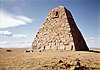
Ames Monument
July 24, 1972 (#72001296 ) 3 miles northwest of Sherman 41°07′53″N 105°23′51″W / 41.131389°N 105.3975°W / 41.131389; -105.3975 (Ames Monument ) Sherman Designated a National Historic Landmark in 2016.
2
Barn at Oxford Horse Ranch
June 25, 1986 (#86001398 ) 868 U.S. Route 287 41°11′18″N 105°35′32″W / 41.188333°N 105.592222°W / 41.188333; -105.592222 (Barn at Oxford Horse Ranch ) Laramie
3
Bath Ranch
December 13, 1985 (#85003211 ) Herrick Lane Rd. 41°24′16″N 105°49′33″W / 41.404444°N 105.825833°W / 41.404444; -105.825833 (Bath Ranch ) Laramie
4
Bath Row
May 8, 1986 (#86001015 ) 155, 157, and 159 N. 6th St. and 611 University Ave. 41°18′46″N 105°35′19″W / 41.312778°N 105.588611°W / 41.312778; -105.588611 (Bath Row ) Laramie
5
Charles E. Blair House
October 31, 1980 (#80004298 ) 170 N. 5th St. 41°18′49″N 105°35′26″W / 41.313611°N 105.590556°W / 41.313611; -105.590556 (Charles E. Blair House ) Laramie
6
N.K. Boswell Ranch Upload image July 21, 1977 (#77001381 ) South of Woods Landing off Wyoming Highway 230 41°00′08″N 106°00′52″W / 41.002214°N 106.014365°W / 41.002214; -106.014365 (N.K. Boswell Ranch ) Woods Landing
7
Brooklyn Lodge
October 24, 1989 (#89001068 ) Wyoming Highway 130 , 7.5 miles west of Centennial41°21′21″N 106°13′57″W / 41.355833°N 106.2325°W / 41.355833; -106.2325 (Brooklyn Lodge ) Centennial
8
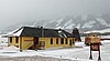
Centennial Depot
November 8, 1982 (#82001828 ) Wyoming Highway 130 41°17′49″N 106°08′13″W / 41.296944°N 106.136944°W / 41.296944; -106.136944 (Centennial Depot ) Centennial Now the Nici Self Historical Museum.
9
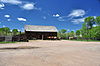
Centennial Work Center
April 11, 1994 (#94000273 ) Off Wyoming Highway 130 northwest of Centennial, Medicine Bow National Forest 41°18′28″N 106°09′25″W / 41.307778°N 106.156944°W / 41.307778; -106.156944 (Centennial Work Center ) Centennial
10
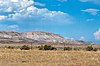
Como Bluff
January 18, 1973 (#73001925 ) On U.S. Route 30 , along Como Ridge 41°53′13″N 106°03′24″W / 41.886944°N 106.056667°W / 41.886944; -106.056667 (Como Bluff ) Rock River Extends into Carbon County
11
John D. Conley House
May 15, 1980 (#80004299 ) 718 Ivinson St. 41°18′41″N 105°35′14″W / 41.311389°N 105.587222°W / 41.311389; -105.587222 (John D. Conley House ) Laramie
12
Cooper Mansion
August 8, 1983 (#83003359 ) 1411 Grand Ave. 41°18′38″N 105°34′38″W / 41.310556°N 105.577222°W / 41.310556; -105.577222 (Cooper Mansion ) Laramie Referred to as Cooper House by its owner, the University of Wyoming, it houses the University's American Studies Program.
13
Dale Creek Crossing (48AB145)
May 9, 1986 (#86001027 ) 4 miles west of Sherman 41°06′15″N 105°27′17″W / 41.104167°N 105.454722°W / 41.104167; -105.454722 (Dale Creek Crossing (48AB145) ) Ames Monument
14
DOE Bridge over Laramie River
February 22, 1985 (#85000411 ) County Road CNA-740 41°35′32″N 105°39′23″W / 41.592222°N 105.656389°W / 41.592222; -105.656389 (DOE Bridge over Laramie River ) Bosler Replaced in 1993
15
Durlacher House
March 21, 2011 (#11000097 ) 501 S. 5th St. 41°18′32″N 105°35′28″W / 41.308889°N 105.591111°W / 41.308889; -105.591111 (Durlacher House ) Laramie
16
East Side School
March 17, 1981 (#81000610 ) Off U.S. Route 30 41°18′33″N 105°35′14″W / 41.309167°N 105.587222°W / 41.309167; -105.587222 (East Side School ) Laramie Located at 710 East Garfield Street.
17
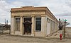
First National Bank of Rock River
November 21, 1988 (#88002532 ) 131 Ave. C 41°44′37″N 105°58′43″W / 41.74351388°N 105.9786111°W / 41.74351388; -105.9786111 (First National Bank of Rock River ) Rock River
18
Flying Horseshoe Ranch Upload image October 12, 2000 (#00001226 ) 156 Dinwiddie Rd. 41°16′13″N 106°06′53″W / 41.270278°N 106.114722°W / 41.270278; -106.114722 (Flying Horseshoe Ranch ) Centennial
19
Fort Sanders Guardhouse
May 1, 1980 (#80004300 ) Kiowa St. 41°16′27″N 105°35′56″W / 41.274167°N 105.598889°W / 41.274167; -105.598889 (Fort Sanders Guardhouse ) Laramie
20
William Goodale House
August 5, 1991 (#91000996 ) 214 S. 14th St. 41°18′37″N 105°34′48″W / 41.310278°N 105.58°W / 41.310278; -105.58 (William Goodale House ) Laramie
21
Ivinson Mansion and Grounds
February 23, 1972 (#72001295 ) 603 Ivinson Ave.[5] 41°18′44″N 105°35′18″W / 41.3122°N 105.5883°W / 41.3122; -105.5883 (Ivinson Mansion and Grounds ) Laramie
22
Jelm-Frank Smith Ranch Historic District Upload image August 31, 1978 (#78002816 ) South of Woods Landing 41°03′33″N 106°00′41″W / 41.059167°N 106.011389°W / 41.059167; -106.011389 (Jelm-Frank Smith Ranch Historic District ) Woods Landing
23
Keystone Work Center Upload image April 11, 1994 (#94000275 ) West of Albany, Medicine Bow National Forest 41°10′09″N 106°14′55″W / 41.169167°N 106.248611°W / 41.169167; -106.248611 (Keystone Work Center ) Albany
24
F.S. King Brothers Ranch Historic District
September 21, 2006 (#06000874 ) Address Restricted Laramie
25
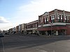
Laramie Downtown Historic District
November 10, 1988 (#88002541 ) Roughly bounded by University Ave., 6th St., Grand Ave., 3rd St., Garfield Ave., and 1st Ave. 41°18′35″N 105°35′38″W / 41.309722°N 105.593889°W / 41.309722; -105.593889 (Laramie Downtown Historic District ) Laramie
26
Lehman-Tunnell Mansion
November 8, 1982 (#82001829 ) 618 Grand Ave. 41°18′38″N 105°35′18″W / 41.310556°N 105.588333°W / 41.310556; -105.588333 (Lehman-Tunnell Mansion ) Laramie
27
Libby Lodge
September 30, 1976 (#76001947 ) Northwest of Centennial on Wyoming Highway 130 41°19′20″N 106°10′19″W / 41.322222°N 106.171944°W / 41.322222; -106.171944 (Libby Lodge ) Centennial
28
Lincoln School
December 5, 2003 (#03001252 ) 209 S. Cedar St. 41°18′43″N 105°35′58″W / 41.311944°N 105.599444°W / 41.311944; -105.599444 (Lincoln School ) Laramie
29
Mountain View Hotel
June 7, 2007 (#07000541 ) 2747 Wyoming Highway 130 41°17′52″N 106°08′24″W / 41.297778°N 106.14°W / 41.297778; -106.14 (Mountain View Hotel ) Centennial
30
North Albany Clubhouse
July 23, 1998 (#98000908 ) Address Restricted 41°57′40″N 105°33′59″W / 41.961111°N 105.566389°W / 41.961111; -105.566389 (North Albany Clubhouse ) Garrett Provided coordinates show a small building at the intersection of Garrett and Tunnel Roads
31
Old Main
July 11, 1986 (#86001536 ) University of Wyoming campus, 9th St. and Ivinson Ave.41°18′43″N 105°35′02″W / 41.311944°N 105.583889°W / 41.311944; -105.583889 (Old Main ) Laramie
32
Parker Ranch House
December 13, 1985 (#85003209 ) Address Restricted Laramie Peak
33
Richardson's Overland Trail Ranch
March 5, 1992 (#92000122 ) 111 Hart Rd. 41°14′29″N 105°42′06″W / 41.241389°N 105.701667°W / 41.241389; -105.701667 (Richardson's Overland Trail Ranch ) Laramie
34
St. Matthew's Cathedral Close
April 12, 1984 (#84003622 ) 104 S. 4th St. 41°18′45″N 105°35′33″W / 41.3125°N 105.5925°W / 41.3125; -105.5925 (St. Matthew's Cathedral Close ) Laramie
35
St. Paulus Kirche
November 25, 1983 (#83004266 ) 602 Garfield 41°18′35″N 105°35′20″W / 41.309722°N 105.588889°W / 41.309722; -105.588889 (St. Paulus Kirche ) Laramie Now known as St. Paul's United Church of Christ of Laramie
36
Snow Train Rolling Stock
May 8, 2013 (#13000265 ) S. 1st & E. Sheridan Sts. 41°18′27″N 105°35′47″W / 41.307381°N 105.596421°W / 41.307381; -105.596421 (Snow Train Rolling Stock ) Laramie
37
Union Pacific Athletic Club
September 13, 1978 (#78002814 ) Off U.S. Route 30 41°19′16″N 105°32′49″W / 41.321111°N 105.546944°W / 41.321111; -105.546944 (Union Pacific Athletic Club ) Laramie Now the Quadra Dangle Square Dance Club. The address is 3905 East Grays Gable Road
38
University Neighborhood Historic District
December 18, 2009 (#09001109 ) Roughly bounded by 6th St., 15th St., University Ave., and Custer St. 41°18′37″N 105°34′59″W / 41.3104°N 105.583119°W / 41.3104; -105.583119 (University Neighborhood Historic District ) Laramie
39
Vee Bar Ranch Lodge
June 30, 1986 (#86001468 ) 2087 Wyoming Highway 130 41°17′49″N 106°00′42″W / 41.296944°N 106.011667°W / 41.296944; -106.011667 (Vee Bar Ranch Lodge ) Laramie
40
Woods Landing Dance Hall
December 13, 1985 (#85003210 ) 2731 Wyoming Highway 230 41°06′37″N 106°00′44″W / 41.110278°N 106.012222°W / 41.110278; -106.012222 (Woods Landing Dance Hall ) Woods Landing
41
Wyoming Territorial Penitentiary
March 29, 1978 (#78002815 ) Off Wyoming Highway 130 41°18′45″N 105°36′32″W / 41.3125°N 105.608889°W / 41.3125; -105.608889 (Wyoming Territorial Penitentiary ) Laramie