National Register of Historic Places listings in Uinta County, Wyoming
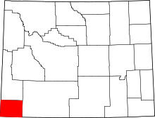
Location of Uinta County in Wyoming
This is a list of the National Register of Historic Places listings in Uinta County, Wyoming.
This is intended to be a complete list of the properties and districts on the National Register of Historic Places in Uinta County, Wyoming, United States. The locations of National Register properties and districts for which the latitude and longitude coordinates are included below, may be seen in a map.[1]
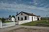
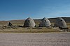
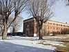
There are 14 properties and districts listed on the National Register in the county.
This National Park Service list is complete through NPS recent listings posted February 18, 2022.[2]
| Albany - Big Horn - Campbell - Carbon - Converse - Crook - Fremont - Goshen - Hot Springs - Johnson - Laramie - Lincoln - Natrona - Niobrara - Park - Platte - Sheridan - Sublette - Sweetwater - Teton - Uinta - Washakie - Weston |
Current listings[]


See also[]
| Wikimedia Commons has media related to National Register of Historic Places in Uinta County, Wyoming. |
- List of National Historic Landmarks in Wyoming
- National Register of Historic Places listings in Wyoming
References[]
- ^ The latitude and longitude information provided in this table was derived originally from the National Register Information System, which has been found to be fairly accurate for about 99% of listings. Some locations in this table may have been corrected to current GPS standards.
- ^ National Park Service, United States Department of the Interior, "National Register of Historic Places: Weekly List Actions", retrieved February 18, 2022.
- ^ Numbers represent an alphabetical ordering by significant words. Various colorings, defined here, differentiate National Historic Landmarks and historic districts from other NRHP buildings, structures, sites or objects.
- ^ The eight-digit number below each date is the number assigned to each location in the National Register Information System database, which can be viewed by clicking the number.
- ^ Emmons, Samuel Franklin, and Edwin Clarence Eckel. Contributions to Economic Geology, 1905. United States Geological Survey Bulletin 285. Washington: GPO, 1906, 345.
| Topics | |
|---|---|
| Lists by state |
|
| Lists by insular areas | |
| Lists by associated state | |
| Other areas | |
| Related | |
| |
Municipalities and communities of Uinta County, Wyoming, United States | ||
|---|---|---|
| City |  | |
| Towns | ||
| CDPs | ||
| Other communities | ||
| Ghost towns | ||
| ||
Categories:
- Lists of National Register of Historic Places in Wyoming by county
- Uinta County, Wyoming
- National Register of Historic Places in Uinta County, Wyoming