National Register of Historic Places listings in Crook County, Wyoming
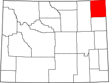
Location of Crook County in Wyoming
This is a list of the National Register of Historic Places listings in Crook County, Wyoming.
This is intended to be a complete list of the properties and districts on the National Register of Historic Places in Crook County, Wyoming, United States. The locations of National Register properties and districts for which the latitude and longitude coordinates are included below, may be seen in a map.[1]
There are 13 properties and districts listed on the National Register in the county.
This National Park Service list is complete through NPS recent listings posted February 18, 2022.[2]
| Albany - Big Horn - Campbell - Carbon - Converse - Crook - Fremont - Goshen - Hot Springs - Johnson - Laramie - Lincoln - Natrona - Niobrara - Park - Platte - Sheridan - Sublette - Sweetwater - Teton - Uinta - Washakie - Weston |
Current listings[]
| [3] | Name on the Register | Image | Date listed[4] | Location | City or town | Description |
|---|---|---|---|---|---|---|
| 1 | Arch Creek Petroglyphs (48CK41) |  |
December 4, 1986 (#86003458) |
Address Restricted | Moorcroft | |
| 2 | DXN Bridge over Missouri River |  |
February 22, 1985 (#85000419) |
Crook County Road 18-200 44°58′59″N 104°29′39″W / 44.983056°N 104.494167°W | Hulett | |
| 3 | Entrance Road-Devils Tower National Monument |  |
July 24, 2000 (#00000854) |
Devils Tower National Monument 44°35′14″N 104°42′52″W / 44.587222°N 104.714444°W | Devils Tower | |
| 4 | Entrance Station-Devils Tower National Monument |  |
July 24, 2000 (#00000853) |
Devils Tower National Monument 44°35′23″N 104°42′00″W / 44.589722°N 104.7°W | Devils Tower | |
| 5 | Inyan Kara Mountain | 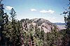 |
April 24, 1973 (#73001929) |
About 15 mi (24 km) south of Sundance in Black Hills National Forest 44°12′45″N 104°20′40″W / 44.2125°N 104.344444°W | Sundance | |
| 6 | McKean Archeological Site (48CK7) |  |
April 1, 1991 (#91000326) |
Within the Keyhole Reservoir[5] 44°21′55″N 104°50′20″W / 44.365278°N 104.838889°W | Moorcroft | |
| 7 | Old Headquarters Area Historic District |  |
July 20, 2000 (#00000852) |
Devils Tower National Monument 44°35′26″N 104°43′13″W / 44.590556°N 104.720278°W | Devils Tower | |
| 8 | Ranch A |  |
March 17, 1997 (#97000227) |
Off Riflepit Rd., approximately 3 mi (4.8 km) east of Interstate 90/U.S. Route 14, Ranch A National Fish Genetics Laboratory 44°29′27″N 104°06′53″W / 44.490833°N 104.114722°W | Beulah | |
| 9 | Sundance School |  |
December 2, 1985 (#85003099) |
108 N. 4th St. 44°24′22″N 104°22′38″W / 44.406111°N 104.377222°W | Sundance | |
| 10 | Sundance State Bank |  |
March 23, 1984 (#84003660) |
301 Main St. 44°24′22″N 104°22′47″W / 44.406111°N 104.379722°W | Sundance | |
| 11 | Tower Ladder-Devils Tower National Monument |  |
July 24, 2000 (#00000855) |
Devils Tower National Monument 44°35′23″N 104°42′50″W / 44.589722°N 104.713889°W | Devils Tower | |
| 12 | Vore Buffalo Jump |  |
April 11, 1973 (#73001930) |
Between Interstate 90 and the old U.S. Route 14, 5 miles west of the South Dakota border[6] 44°32′09″N 104°09′24″W / 44.535833°N 104.156667°W | Sundance | |
| 13 | Wyoming Mercantile |  |
April 16, 1991 (#91000435) |
Wyoming Highway 24 44°38′25″N 104°11′01″W / 44.640278°N 104.183611°W | Aladdin |
See also[]
| Wikimedia Commons has media related to National Register of Historic Places in Crook County, Wyoming. |
- List of National Historic Landmarks in Wyoming
- National Register of Historic Places listings in Wyoming
References[]
- ^ The latitude and longitude information provided in this table was derived originally from the National Register Information System, which has been found to be fairly accurate for about 99% of listings. Some locations in this table may have been corrected to current GPS standards.
- ^ National Park Service, United States Department of the Interior, "National Register of Historic Places: Weekly List Actions", retrieved February 18, 2022.
- ^ Numbers represent an alphabetical ordering by significant words. Various colorings, defined here, differentiate National Historic Landmarks and historic districts from other NRHP buildings, structures, sites or objects.
- ^ The eight-digit number below each date is the number assigned to each location in the National Register Information System database, which can be viewed by clicking the number.
- ^ Mulloy, William. "The McKean Site in Northeastern Wyoming". Southwestern Journal of Anthropology 10.4 (1954): 432-460: 435.
- ^ Location derived from this Wyoming State Historic Preservation Office website; the NRIS lists the site as "Address Restricted"
| Topics | |
|---|---|
| Lists by state |
|
| Lists by insular areas | |
| Lists by associated state | |
| Other areas | |
| Related | |
| |
Municipalities and communities of Crook County, Wyoming, United States | ||
|---|---|---|
| Towns |  | |
| CDP | ||
| Unincorporated communities | ||
| ||
Categories:
- Lists of National Register of Historic Places in Wyoming by county
- Crook County, Wyoming
- National Register of Historic Places in Crook County, Wyoming