Parker County, Texas
Parker County | |
|---|---|
U.S. county | |
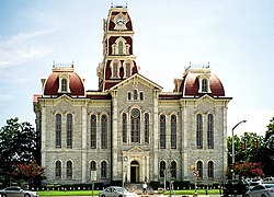 The Parker County courthouse in Weatherford | |
 Flag | |
 Location within the U.S. state of Texas | |
 Texas's location within the U.S. | |
| Coordinates: 32°47′N 97°49′W / 32.78°N 97.81°W | |
| Country | |
| State | |
| Founded | 1856 |
| Seat | Weatherford |
| Largest city | Weatherford |
| Area | |
| • Total | 910 sq mi (2,400 km2) |
| • Land | 903 sq mi (2,340 km2) |
| • Water | 6.6 sq mi (17 km2) 0.7%% |
| Population (2010) | |
| • Total | 116,927 |
| • Density | 129/sq mi (50/km2) |
| Time zone | UTC−6 (Central) |
| • Summer (DST) | UTC−5 (CDT) |
| Congressional district | 12th |
| Website | www |

Parker County is a county located in the U.S. state of Texas. As of the 2010 census, its population was 116,927.[1] The county seat is Weatherford.[2] The county was created in 1855 and organized the following year.[3] It is named for Isaac Parker, a state legislator who introduced the bill that established the county in 1855.[4][5]
Parker County is included in the Dallas-Fort Worth-Arlington, TX Metropolitan Statistical Area.
Geography[]
According to the U.S. Census Bureau, the county has a total area of 910 square miles (2,400 km2), of which 903 square miles (2,340 km2) are land and 6.6 square miles (17 km2) (0.7%) are covered by water.[6] The county is intersected by the Brazos River.[7]
Highest point[]
Slipdown Mountain and Slipdown Bluff, at a height of 1,368 feet (417 m), are the highest points in Parker County.[8] They are located just east of the Advance community, southwest of Poolville.
Major highways[]
Adjacent counties[]
- Wise County (north)
- Tarrant County (east)
- Johnson County (southeast)
- Hood County (south)
- Palo Pinto County (west)
- Jack County (northwest)
- The following demographics have been provided by the Parker County Economic Development Council which is a 501(c)(6) business league. We are dedicated to the retention of our current businesses and aide in managing the incoming businesses. For more information following the link http://parkercountyedc.com/ we are here to help inform our community!
Demographics[]
| Historical population | |||
|---|---|---|---|
| Census | Pop. | %± | |
| 1860 | 4,213 | — | |
| 1870 | 4,186 | −0.6% | |
| 1880 | 15,870 | 279.1% | |
| 1890 | 21,682 | 36.6% | |
| 1900 | 25,823 | 19.1% | |
| 1910 | 26,331 | 2.0% | |
| 1920 | 23,382 | −11.2% | |
| 1930 | 18,759 | −19.8% | |
| 1940 | 20,482 | 9.2% | |
| 1950 | 21,528 | 5.1% | |
| 1960 | 22,880 | 6.3% | |
| 1970 | 33,888 | 48.1% | |
| 1980 | 44,609 | 31.6% | |
| 1990 | 64,785 | 45.2% | |
| 2000 | 88,495 | 36.6% | |
| 2010 | 116,927 | 32.1% | |
| 2019 (est.) | 142,878 | [9] | 22.2% |
| U.S. Decennial Census[10] 1850–2010[11] 2010–2019[1] | |||
As of the census of 2019, 136,506 people, 48,346 households, and 37,416 families resided in the county. The population density was 150 people per square mile. The 48,346 housing units averaged 53 per square mile. The racial makeup of the county was 90.32% White, 1.80% African American, 0.81% Native American, 0.78% Asian, 0.04% Pacific Islander, 4.02% from other races, and 2.24% from two or more races.
In the county, the population was distributed as 26.55% under the age of 19, 11.63% from 20 to 29, 24.74% from 30 to 49, 21% from 50 to 64, and 16.08% who were 65 years of age or older. The median age was 39 years. the female population was 50.24% to 49.76% male.
The median income for a household in the county was $78,309. Males had a median income of $37,913 versus $25,412 for females. 79.90% of the population were homeowners, and 20.10% were renters, with 94.76 housing units being occupied.
Communities[]
Cities (multiple counties)[]
- Azle (mostly in Tarrant County)
- Cresson (partly in Hood and Johnson Counties)
- Fort Worth (mostly in Tarrant County, with small parts in Denton, Wise, and Parker Counties)
- Mineral Wells (mostly in Palo Pinto County)
- Reno (small part in Tarrant County)
Cities[]
- Brock
- Hudson Oaks
- Weatherford (county seat)
- Willow Park
Towns[]
- Annetta
- Annetta North
- Annetta South
- Millsap
- Sanctuary
- Cool
- Springtown
- Dennis
Census-designated places[]
- Briar (partly in Wise and Tarrant Counties)
- Horseshoe Bend
- Western Lake
Unincorporated communities[]
Politics[]
Parker County, like most suburban counties in the Dallas–Fort Worth metropolitan area, has been a Republican stronghold for decades. Republicans have held all public offices since 1999 and the county has not voted for a Democratic presidential candidate since 1976.[citation needed]
Notable people[]
- Oliver Loving, Loving-Goodnight Cattle Trail
- Bose Ikard, trusted cattle driver of Oliver Loving and Charles Goodnight
- Mary Martin, star of stage and screen
- S.W.T. Lanham, last Confederate veteran to serve as governor of Texas
- Jim Wright, youngest mayor of Weatherford, TX, Speaker of the U.S. House of Representatives
See also[]
- List of museums in North Texas
- National Register of Historic Places listings in Parker County, Texas
- Recorded Texas Historic Landmarks in Parker County
References[]
- ^ Jump up to: a b "State & County QuickFacts". United States Census Bureau. Archived from the original on October 18, 2011. Retrieved December 22, 2013.
- ^ "Find a County". National Association of Counties. Archived from the original on May 31, 2011. Retrieved 2011-06-07.
- ^ "Texas: Individual County Chronologies". Texas Atlas of Historical County Boundaries. The Newberry Library. 2008. Retrieved May 26, 2015.
- ^ "PARKER COUNTY". Retrieved 24 March 2016.
- ^ "PARKER, ISAAC". Retrieved 24 March 2016.
- ^ "2010 Census Gazetteer Files". United States Census Bureau. August 22, 2012. Retrieved May 6, 2015.
- ^ Ripley, George; Dana, Charles A., eds. (1879). . The American Cyclopædia.
- ^ "Parker County Highpoint Trip Report". Retrieved 24 March 2016.
- ^ "Population and Housing Unit Estimates". United States Census Bureau. May 24, 2020. Retrieved May 27, 2020.
- ^ "U.S. Decennial Census". United States Census Bureau. Archived from the original on April 26, 2015. Retrieved May 6, 2015.
- ^ "Texas Almanac: Population History of Counties from 1850–2010" (PDF). Texas Almanac. Retrieved May 6, 2015.
- ^ Leip, David. "Dave Leip's Atlas of U.S. Presidential Elections". uselectionatlas.org. Retrieved 2018-07-28.
External links[]
- Parker County government's website
- The Parker County Poor Farm
- Historic photos from the Weatherford College Library, hosted by the Portal to Texas History
- Parker County in Handbook of Texas Online
| show Places adjacent to Parker County, Texas |
|---|
| show Municipalities and communities of Parker County, Texas, United States |
|---|


Coordinates: 32°47′N 97°49′W / 32.78°N 97.81°W
| show Authority control |
|---|
- Texas counties
- Parker County, Texas
- Dallas–Fort Worth metroplex
- 1856 establishments in Texas
- Populated places established in 1856