Penang Island
Native name: Pulau Pinang | |
|---|---|
 Penang Island (red) within the State of Penang (left) and West Malaysia (right) | |
| Geography | |
| Location | Southeast Asia |
| Coordinates | 05°25′22″N 100°15′57″E / 5.42278°N 100.26583°ECoordinates: 05°25′22″N 100°15′57″E / 5.42278°N 100.26583°E |
| Archipelago | Malay Archipelago |
| Adjacent bodies of water | Malacca Strait (west), Penang Strait (east) |
| Area | 293 km2 (113 sq mi) |
| Highest point | Penang Hill |
| Administration | |
| State | |
| Local government | |
| Demographics | |
| Population | 722,384 (2010)[1] |
| Pop. density | 2,465.47/km2 (6385.54/sq mi) |

Penang Island is the main constituent island of the Malaysian state of Penang. Located in the Strait of Malacca, off the northwestern coast of Peninsular Malaysia, it is separated from the mainland by the Penang Strait. The island is home to nearly half of Penang's population; the state capital George Town, which covers the island and the five outlying islets, is Malaysia's third-largest city by population.
History[]
Formerly known as Prince of Wales Island or Pulo Penang, its city George Town was founded by Francis Light of the British East India Company in 1786. The city once served as the capital of the Straits Settlements, a loose grouping of British crown colonies that included Melaka and Singapore. The island became a regional centre for spice production and a bustling harbour during the heyday of British rule.[2][3][4] The Japanese briefly occupied Penang during World War II, before surrendering the colony to the British upon the war's end. Penang was then merged into the Federation of Malaya (now Malaysia), which gained independence from the British in 1957. George Town had been granted city status in that year; the city's jurisdiction was eventually expanded to encompass the entire island by 2015.[5]
The island is well known as the Silicon Valley of the East and a booming tourist destination. George Town's historical core is a UNESCO World Heritage Site, while its beaches and the Penang Hill, the tallest point in Penang, are popular amongst tourists as well.[6]
Gurney Wharf is a planned seafront park, with land for this purpose currently being reclaimed off Gurney Drive in George Town, Penang. Intended as a "new iconic waterfront destination for Penang", Phase 1 of Gurney Wharf is scheduled for completion by 2018.[7][8] Upon the expected completion of Gurney Wharf by August 2021,[9] the 24.28-hectare seafront park will comprise four distinct recreational areas - a beach, a coastal grove, a water garden, and a seaside retail food and beverages (F&B) area.[10]
Etymology[]

The state of Penang is named after Penang Island, which was, in turn, named after the areca nut palm (Areca catechu, family: Palmae), also known as pinang in Malay.[11] To this day, the island has also been known as the Pearl of the Orient, or Pulau Mutiara (The Island of Pearls) in Malay.
The early Malays called the island Pulau Ka-Satu (First Island) because it was the largest island encountered on the trading sea-route between Lingga and Kedah.[12] The Siamese, then the overlord of the Kedah Sultanate, referred to the island as Koh Maak (Thai: เกาะหมาก), meaning areca nut palm island.[13][14] In the 15th century, the island was referred to as Bīnláng Yù (simplified Chinese: 梹榔屿; traditional Chinese: 梹榔嶼) in the navigational drawings used by Admiral Zheng He of Ming China.[13][15] The 16th-century Portuguese cartographer Emanuel Godinho de Eredia also referred to the island as Pulo Pinaom.[16]
Geography[]


With an area of 293 km2 (113 sq mi), slightly ⅓ the size of Singapore, Penang Island is the fourth-largest island in Malaysia.[17] It is also the most densely populated island in the country, with a population density of 2,465.5/km2 (6,386/sq mi).[18]
Penang Island is geographically separated from the Malay Peninsula by the Penang Strait. As for the terrain, much of the centre of Penang Island consists of granitic hills covered by rainforest jungles. The central hills of Penang Island, including Penang Hill, serve as a giant green lung for the entire island and an important forested catchment area.[19]
Generally speaking, the island can be distinguished into five areas:
- The northeastern plains form a triangular promontory where George Town is centred. This densely populated city centre is the administrative, commercial and cultural centre of Penang.
- The southeast, where Bayan Lepas is located, was once an agricultural area consisting of rice fields and mangroves. Due to the massive industrialisation of the 1970s, this area has been developed into new townships and industrial areas.
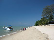
- The north, including Batu Ferringhi, Tanjung Bungah and Tanjung Tokong, consists of narrow sandy beaches lined with resort hotels and residences that form the northwestern edge of George Town.
- The southwest (Balik Pulau) contains the only large pockets of scenic countryside with fishing villages, fruit orchards, and mangroves.
- The central hill range, with the highest peak being Penang Hill at 833 m (2,733 ft) above sea level, is an important forested catchment area.
Land reclamation had been carried out by the British authorities since the 19th century, particularly in George Town, where the original shoreline was pushed further out to sea.[20] To this day, land reclamation is still ongoing in certain areas of the island, such as the proposed neighbourhood of Seri Tanjung Pinang.
Extreme points[]
- Northernmost: Batu Ferringhi (5.482877° N, 100.256429° E)
- Easternmost: George Town (5.418714° N, 100.345521° E)
- Southernmost: Teluk Tempoyak (5.257156° N, 100.27957° E)
- Westernmost: Penang National Park (5.472174° N, 100.175159° E)
Climate[]
Like the rest of Malaysia, Penang Island has a tropical rainforest climate under the Köppen climate classification (Af), although it also borders on a tropical monsoon climate. Penang Island does experience slightly drier conditions between December and February of the following year. The city sees on average around 2,477 millimetres (97.5 in) of precipitation annually with the lowest being 60 millimetres (2.4 in) in February while the highest was around 210 millimetres (8.3 in) between August and October.[21]
Penang Island's proximity to the island of Sumatra, Indonesia makes it susceptible to dust particles carried by wind from the perennial but transient forest fires, creating a yearly phenomenon known as the Southeast Asian haze.[22][23] The haze season typically hits between July and October.
Weather forecasts in Penang Island is served by the Bayan Lepas Regional Meteorological Office, which acts as the primary weather forecast facility for northern Peninsular Malaysia.[24]
| hideClimate data for Penang | |||||||||||||
|---|---|---|---|---|---|---|---|---|---|---|---|---|---|
| Month | Jan | Feb | Mar | Apr | May | Jun | Jul | Aug | Sep | Oct | Nov | Dec | Year |
| Average high °C (°F) | 31.6 (88.9) |
32.2 (90.0) |
32.2 (90.0) |
31.9 (89.4) |
31.6 (88.9) |
31.4 (88.5) |
31.0 (87.8) |
30.9 (87.6) |
30.4 (86.7) |
30.4 (86.7) |
30.7 (87.3) |
31.1 (88.0) |
31.3 (88.2) |
| Daily mean °C (°F) | 26.9 (80.4) |
27.4 (81.3) |
27.6 (81.7) |
27.7 (81.9) |
27.6 (81.7) |
27.3 (81.1) |
26.9 (80.4) |
26.8 (80.2) |
26.5 (79.7) |
26.4 (79.5) |
26.5 (79.7) |
26.7 (80.1) |
27.0 (80.6) |
| Average low °C (°F) | 23.2 (73.8) |
23.5 (74.3) |
23.7 (74.7) |
24.1 (75.4) |
24.2 (75.6) |
23.8 (74.8) |
23.4 (74.1) |
23.4 (74.1) |
23.2 (73.8) |
23.3 (73.9) |
23.3 (73.9) |
23.4 (74.1) |
23.5 (74.4) |
| Average rainfall mm (inches) | 68.7 (2.70) |
71.7 (2.82) |
146.4 (5.76) |
220.5 (8.68) |
203.4 (8.01) |
178.0 (7.01) |
192.1 (7.56) |
242.4 (9.54) |
356.1 (14.02) |
383.0 (15.08) |
231.8 (9.13) |
113.5 (4.47) |
2,407.6 (94.79) |
| Average rainy days (≥ 1.0 mm) | 5 | 6 | 9 | 14 | 14 | 11 | 12 | 14 | 18 | 19 | 15 | 9 | 146 |
| Mean monthly sunshine hours | 248.8 | 233.2 | 235.3 | 224.5 | 203.6 | 202.4 | 205.5 | 188.8 | 161.0 | 170.2 | 182.1 | 209.0 | 2,464.4 |
| Source: NOAA[25] | |||||||||||||
Demographics[]
According to the 2010 Census from the Malaysian federal government, Penang Island had a population of 722,384, or about 46% of Penang's total population.[26] The island has a predominantly Chinese population, which includes the Peranakans; more than 53% of the island's population were of Chinese descent. The Bumiputeras, including ethnic Malays and East Malaysian indigenous tribes such as the Dayaks and Kadazans, collectively comprised nearly 32% of the island's population. Ethnic Indians constituted another 9% of Penang Island's population. These were in addition to small, but prominent, Eurasian and Siamese minorities.[27] In particular, most of the nearly 1,500 Eurasians remain concentrated at the Pulau Tikus suburb.[28][29]
George Town currently has a significant expatriate population, many of whom chose to retire in Penang as part of the Malaysia My Second Home programme. In recent years, George Town has been acknowledged as one of the best cities to retire within South-East Asia, as reported by CNN and Forbes.[30][31] Expatriates formed almost 6% of Penang Island's population as of 2010, and are concentrated around George Town's northern suburbs such as Tanjung Bungah and Batu Ferringhi.[32]
See also[]
Notes[]
| Wikimedia Commons has media related to Penang Island. |
- ^ "Population Distribution and Demography". Cite journal requires
|journal=(help) - ^ Souza, George Bryan (2014). Hinterlands and Commodities: Place, Space, Time and the Political Economic Development of Asia over the Long Eighteenth Century. BRILL. ISBN 9789004283909.
- ^ "When Penang became a Spice Island". Penang Monthly. 21 January 2016. Retrieved 15 October 2016.
- ^ Wong, Yee Tuan (2015). Penang Chinese Commerce in the 19th Century: The Rise and Fall of the Big Five. Singapore: ISEAS-Yusof Ishak Institute. ISBN 9789814515023.
- ^ "George Town meliputi 'pulau', jelas Datuk Bandar" (PDF). Buletin Mutiara. 1 May 2015.
- ^ Lianne Chia (26 January 2017). "A Silicon Valley of the East: Penang's thriving start-up community". Channel NewsAsia. Retrieved 27 May 2017.
- ^ "Gurney Wharf, Penang's new waterfront park-in-the-city". 23 February 2016. Retrieved 10 April 2017.
- ^ "Makeover for Gurney Drive - Nation - The Star Online".
- ^ "Gurney Wharf expected to be completed by Aug, 2021". 2 February 2020. Retrieved 4 May 2020.
- ^ "GURNEY WHARF - A Penang State Project". Retrieved 4 May 2020.
- ^ Simon Gardner, Pindar Sidisunthorn and Lai Ee May 2011. Heritage Trees of Penang, p. 206. Penang: Areca Books. ISBN 978-967-57190-6-6
- ^ "Welcome to Penang State Museum". Penangmuseum.gov.my. Retrieved 9 November 2012.
- ^ Jump up to: a b Raymond, Boon. (19 March 2010) Penang, Penang lang(槟城人) lah : Penang is called Koh Maak, not Koh Opium. Teochiewkia2010.blogspot.com.[unreliable source?] Retrieved on 11 August 2011.
- ^ "Archived copy" ปีนัง : พันเรื่องถิ่นแผ่นดินไทย โดยศ.ดร.เอนก เหล่าธรรมทัศน์ (Press release) (in Thai). Komchadluek. Archived from the original on 29 March 2013. Retrieved 13 January 2013.CS1 maint: archived copy as title (link)
- ^ Penang Special Attractions | Penang Travel Tip | Best Tourist Location in Asia Archived 11 January 2014 at the Wayback Machine. Penangspecial.com. Retrieved on 11 August 2011.
- ^ "Betel Nut Island". Retrieved 13 September 2014.
- ^ UN System-Wide Earthwatch Web Site
- ^ Nathaniel Fernandez (26 July 2014). "Making Penang more liveable". The Star. Retrieved 20 January 2016.
- ^ Nasution, Khoo: The sustainable Penang initiative. Penang: IIED, 2001|
- ^ Cheah, Jin Seng (2013). Penang: 500 Early Postcards. Editions Didier Millet. ISBN 9789671061718.
- ^ Tijs Neutens; Philippe de Maeyer (16 October 2009). Developments in 3D Geo-Information Sciences. Springer Science & Business Media. pp. 206–. ISBN 978-3-642-04791-6.
- ^ "Why is South-East Asia's annual haze so hard to deal with?". The Economist. 7 July 2013. ISSN 0013-0613. Retrieved 15 October 2016.
- ^ "Sumatra haze blankets northern Malaysia". Planet Ark. 23 September 2002. Retrieved 19 July 2008.
- ^ "Malaysian Meteorological Department – Pejabat Meteorologi Bayan Lepas". Met.gov.my. 16 December 2007. Archived from the original on 10 January 2011. Retrieved 3 January 2011.
- ^ "Penang/Bayan Lepas Climate Normals 1961–1990". National Oceanic and Atmospheric Administration. Retrieved 4 February 2015.
- ^ Jump up to: a b "Population Distribution and Demography" (PDF). Malaysian Department of Statistics. Archived from the original (PDF) on 13 November 2013.
- ^ "Penang Heritage Trust". www.pht.org.my. Retrieved 2 May 2017.
- ^ http://www.penangstory.net.my/mino-content-paperanthony.html
- ^ http://www.thestar.com.my/news/community/2014/01/04/where-the-eurasians-set-words-to-music-so-little-is-known-about-busy-kelawai-road-in-the-old-days/
- ^ https://money.cnn.com/gallery/retirement/2016/01/06/best-places-to-retire-abroad/6.html
- ^ Avenue, Next. "No. 3: George Town, Malaysia - pg.4". Forbes. Retrieved 17 October 2016.
- ^ "Key summary statistics for Local Authority areas, Malaysia, 2010" (PDF). Department of Statistics, Malaysia. Archived from the original (PDF) on 5 February 2015. Retrieved 19 June 2013.
References[]
| Authority control: National libraries |
|---|
- Penang Island
- Islands of Penang
- Populated coastal places in Malaysia
- Populated places established in 1786
- 1786 establishments in Asia
- 1786 establishments in the British Empire