Pennant Hills, New South Wales
| Pennant Hills Sydney, New South Wales | |||||||||||||||
|---|---|---|---|---|---|---|---|---|---|---|---|---|---|---|---|
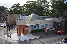 Pennant Hills Library, Yarrara Road | |||||||||||||||
 | |||||||||||||||
| Population | 7,287 (2016 census)[1] | ||||||||||||||
| Postcode(s) | 2120 | ||||||||||||||
| Elevation | 167 m (548 ft) | ||||||||||||||
| Location | 18 km (11 mi) north-west of Sydney CBD | ||||||||||||||
| LGA(s) | Hornsby | ||||||||||||||
| Region | North Shore | ||||||||||||||
| State electorate(s) | Epping, Hornsby | ||||||||||||||
| Federal Division(s) | Berowra | ||||||||||||||
| |||||||||||||||
Pennant Hills is a suburb on the Upper North Shore[2] of Sydney, New South Wales, Australia. Pennant Hills is located 18 kilometres north-west of the Sydney central business district in the local government area of Hornsby Shire. West Pennant Hills is a separate suburb to the West of Pennant Hills and is part of the Hills District.
History[]
The area was first explored by Governor Arthur Phillip shortly after 15 April 1788. It was noted that the party saw 'fine views of the mountains inland' (the Blue Mountains). Governor Phillip 'did not doubt that a large river would be found' nearby.[citation needed]
The first white settlement occurred in the area with the establishment of convict timber camps in the time of Governor Lachlan Macquarie. Permanent white settlement of Pennant Hills began only in the 1840s and took off with the arrival of the Northern railway line in the 1880s. In August 1912 the federal government opened a Wireless Telegraphy Station, the first of its kind on a national level.[3] The suburb has grown considerably since the 1950s, when the motor car became commonplace.
There are two theories about the origin of the suburb's name. One is that the name comes from a hill where a pennant was flown as a signal during the early days of New South Wales. However, though such signals were certainly used, there is no evidence that such a pennant was ever flown at what is now Pennant Hills, but in the early 19th century the name applied to the whole ridge down as far as Mobbs Hill, which has a Telegraph Road to commemorate the signalling station. Also, references to the suburb of Pennant Hills were written 20 years before the establishment of pennant stations (Patrick 1994:79–80). Elizabeth MacArthur records receiving a flag signal at Parramatta that her husband John had returned from England in 1806. The other theory says that Pennant Hills was named after an 18th-century botanist, Thomas Pennant (Patrick 1994:79–80), though there is no contemporary evidence for this either. The fact that the area was first referred to as "Pendant Hills" in the Sydney Gazette when first published in 1803 makes this theory unlikely, as there was no Thomas Pendant either.
The name Pennant Hills originally applied to the area now known as West Pennant Hills, located in the Hills District. However, when the northern railway line was built it passed through what is now Pennant Hills, so a suburb grew around the station and took on the name. The area around Thompsons Corner was renamed West Pennant Hills. Pennant Hills is hilly and the highest altitude is at Observatory Park on Pennant Hills Road, which once was the site of the old astronomical observatory.
During the 1960s and 1970s, Pennant Hills was the site of Chelmsford Private Hospital, where the unorthodox psychiatric Deep Sleep Therapy conducted by Dr Harry Bailey resulted in the deaths of dozens of patients.
Commercial areas[]
Pennant Hills is one of the major commercial centres of Hornsby Shire. Several dozen shops are located at the north-west of the railway line, along with the local Pennant Hills Library. Several restaurants and cafes are located around Yarrara Road. Pennant Hills Marketplace, a local shopping centre, is located along Hillcrest Road. Residential houses are found in all areas in Pennant Hills, with recent modern apartments and office towers found along Pennant Hills Road. A significant commercial/industrial area can be found along Pennant Hills Road.
Pennant Hills is home to several entertainment venues including the Pennant Hills Hotel.
Transport[]

Pennant Hills railway station is on the Northern Line of the Sydney Trains network.
Pennant Hills Road is one of Sydney's major thoroughfares. Bus services by Transdev NSW and Hillsbus have their terminus in Pennant Hills and run to West Pennant Hills, Castle Hill and Cherrybrook.
Churches[]
- Pennant Hills was established as a Catholic parish in 1928 and a number of Catholic churches have been built since then. The parish's current church, St. Agatha's, was built in 1979.
- St Mark's Anglican Church,[4]
- Pennant Hills Baptist Church[5]
- Pennant Hills Uniting Church[6]
- Thornleigh Seventh-day Adventist Church is located in Pennant Hills.
- Pennant Hills is also home to the first Danish Church in Australia. Crown Prince Frederik and Crown Princess Mary of Denmark made an official visit there on 6 March 2005.[7]
Schools[]
Pennant Hills has two public schools: Pennant Hills Public School established in 1925[8] and Pennant Hills High School established in 1966,[9] and two Catholic schools, Mount St Benedict College a girls secondary school[10] and St. Agatha's Catholic Primary School.[11]
Sport and recreation[]
Parks and reserves[]

Pennant Hills is surrounded on two sides by large swathes of bushland. To the east, the suburb is bordered by the upper reaches of the Lane Cove River and its associated national park, whilst in the north-west, Pennant Hills borders Berowra Valley National Park. Both of these reserves contain extensive walking tracks within the boundaries of the suburb, with some linking to the Great North Walk.[12][13]
Pennant Hills also contains many public parks, the largest being the Pennant Hills Park sportsground. This complex hosts many sporting facilities consisting of the Ern Holmes Oval for Australian Football and cricket, tennis and netball courts, a rugby union field, a football pitch, two hockey fields and an archery range.[14][15][16] The Ern Holmes Oval was the home ground of the Pennant Hills Demons Australian Football Club until 2011.[17]
Lilian Fraser Garden is also located in Pennant Hills. Originally maintained for many years by the noted government biologist Dr Lilian Fraser, after her death in 1987 her collection of rare and exotic plants was passed on to Hornsby Shire Council.[18] Open free of charge to the public for viewing, the garden can also be hired for special events for a fee.[19]
Sport and leisure[]
Pennant Hills, due to its wide array of sporting facilities, plays home to a large number of sporting organisations. These organisations include the Pennant Hills Football Club, which was established in 1957, and the Pennant Hills Demons AFC, which has seen nine players go on to compete in the AFL.[20] Although the Ern Holmes Oval is no longer the home ground of the Demons premiership team due to its size, many of the club's junior teams still compete in Pennant Hills.
Pennant Hills is also home to the Baden Powell Scout Centre, which borders the Lane Cove National Park. Opened in 1929, it initially served as a permanent camp for the unemployed during the Great Depression, and was visited by the Lord Baden-Powell himself in 1931.[21] Situated on 36 acres of bushland, the centre is now home to the John Hill training centre and provides accommodation, catering and conference facilities for large groups, as well as activities such as high-ropes and rock climbing for camps.
The Pennant Hills area is home to the Pennant Hills Cherrybrook Rugby League Club affectionately known as the Stags. Whilst originally based at Pennant Hills Park the club now plays out of Greenway Oval at Cherrybrook. The club competes with distinction in the North Sydney District Junior Rugby League competition.
Population[]
Demographics[]
The population according to the 2016 census was 7,287. Of these:[1]
- The median age was 40 years, compared to the national median of 38 years. Children aged 0–14 years made up 18.0% of the population and people aged 65 years and over made up 16.5% of the population.
- 59.3% of people were born in Australia. The most common countries of birth were China 6.6%, India 4.0%, England 3.4%, Hong Kong 2.9% and South Korea 2.5%.
- 64.7% of people only spoke English at home. Other languages spoken at home included Mandarin 7.4%, Cantonese 5.5%, Korean 3.0%, Hindi 2.0% and Arabic 1.5%.
- The most common responses for religion were No Religion 28.5%, Catholic 21.9% and Anglican 14.4%.
Notable residents[]
- Early North Shore settler James Milson.
- Former Attorney General of Australia Philip Ruddock.
- St Kilda midfielder Lenny Hayes, who played for the Pennant Hills Demons in the NSW Football League.
- Essendon tagger Mark McVeigh, who also played for the Demons in the NSW Football League.
- Sydney Swans Football Club midfielder Jarrad McVeigh, who also played for Pennant Hills Demons in the NSW Football League.
- John and Ilsa Konrads, siblings and world record-breaking swimmers.
- Michaela Baranov, a contestant on the seventh season of The X Factor Australia
- Geraint F. Lewis, astrophysicist at the University of Sydney
Climate[]
Because of its elevation, Pennant Hills has a mean of 21.8 °C (71.2 °F) in the warmest month, which is just below the subtropical isotherm of 22 °C (72 °F). As such, Pennant Hills has an Oceanic climate (Cfb). Its highs are around two degrees warmer than Sydney CBD in the summer, and a degree cooler in the winter. Whilst the rainfall is evenly distributed, the wettest month is March and the driest is September.
| hideClimate data for Pennant Hills | |||||||||||||
|---|---|---|---|---|---|---|---|---|---|---|---|---|---|
| Month | Jan | Feb | Mar | Apr | May | Jun | Jul | Aug | Sep | Oct | Nov | Dec | Year |
| Average high °C (°F) | 27.6 (81.7) |
27.3 (81.1) |
25.5 (77.9) |
22.2 (72.0) |
19.1 (66.4) |
16.3 (61.3) |
15.8 (60.4) |
17.9 (64.2) |
20.9 (69.6) |
23.4 (74.1) |
25.1 (77.2) |
27.0 (80.6) |
22.3 (72.1) |
| Daily mean °C (°F) | 21.8 (71.2) |
21.7 (71.1) |
20.1 (68.2) |
17.0 (62.6) |
13.8 (56.8) |
11.3 (52.3) |
10.5 (50.9) |
10.9 (51.6) |
14.5 (58.1) |
17.1 (62.8) |
19.1 (66.4) |
21.0 (69.8) |
16.6 (61.8) |
| Average low °C (°F) | 16.1 (61.0) |
16.1 (61.0) |
14.8 (58.6) |
11.8 (53.2) |
8.6 (47.5) |
6.3 (43.3) |
5.2 (41.4) |
6.1 (43.0) |
8.1 (46.6) |
10.8 (51.4) |
13.1 (55.6) |
15.0 (59.0) |
11.0 (51.8) |
| Average precipitation mm (inches) | 100.6 (3.96) |
115.8 (4.56) |
121.7 (4.79) |
104.5 (4.11) |
81.9 (3.22) |
111.4 (4.39) |
80.6 (3.17) |
63.5 (2.50) |
56.3 (2.22) |
69.0 (2.72) |
78.0 (3.07) |
92.1 (3.63) |
1,074.7 (42.31) |
| Average precipitation days (≥ 0.2 mm) | 10.6 | 11.4 | 12.1 | 11.3 | 9.5 | 10.9 | 9.2 | 8.5 | 8.8 | 9.5 | 9.9 | 10.6 | 122.3 |
| Source: Bureau of Meteorology (temperatures, 1907–1943)[22] | |||||||||||||
References[]
- ^ Jump up to: a b Australian Bureau of Statistics (27 June 2017). "Pennant Hills (State Suburb)". 2016 Census QuickStats. Retrieved 20 August 2017.

- ^ https://postcodez.com.au/postcodes.cgi?search_suburb=pennant+hills&search_state=&type=search
- ^ Crowley, Frank (1974), A New History of Australia, William Heinemann, Melbourne, Victoria, p. 301
- ^ "St Mark's Anglican Church Pennant Hills". Retrieved 23 March 2013.
- ^ "Pennant Hills Baptist Church". Retrieved 23 March 2013.
- ^ "Pennant Hills Uniting Church". Retrieved 23 March 2013.
- ^ "The Danish Church in Australia". Church in Sydney has been the setting for several major events, from the Olympics in 2000, the inauguration of the church in Pennant Hills in 2002 and the visit of the royal couple in 2005, to 'Frederik's Church' was named by the Crown Prince in 2009. Retrieved 23 March 2013.
- ^ "Pennant Hills Public School". Pennant Hills Public School, established in 1925 and situated on two sites 500 metres apart. Retrieved 23 March 2013.
- ^ "Pennant Hills High School". Pennant Hills High School is set in large grounds and situated in a well-established residential area in the north-west of Sydney. The school was established in 1966. Retrieved 23 March 2013.
- ^ "Mount St Benedict College". Retrieved 23 March 2013.
- ^ "St Agatha's Catholic Primary School". Archived from the original on 15 May 2013. Retrieved 23 March 2013.
- ^ "Berowra Valley National Park". NSW National Parks and Wildlife Service. Retrieved 26 December 2016.
- ^ "Pennant Hills West Pymble Fire Trail". NSW National Parks and Wildlife Service. Retrieved 26 December 2016.
- ^ "Sportsgrounds and Ovals". Hornsby Shire Council. Retrieved 26 December 2016.
- ^ "Home". Eastwood Thornleigh District Tennis Association. Retrieved 26 December 2016.
- ^ "Welcome to Northern Archers of Sydney". Northern Archers. Retrieved 26 December 2016.
- ^ "History". Pennant Hills Demons. Retrieved 26 December 2016.
- ^ "Lilian Fraser Garden". Hornsby Shire Council. Retrieved 26 December 2016.
- ^ "Lilian Fraser Garden (fees)" (PDF). Hornsby Shire Council. Retrieved 26 December 2016.
- ^ "Player Development History". Pennant Hills Demons. Retrieved 26 December 2016.
- ^ "A Brief History of Baden-Powell Scout Centre". Scouts Australia NSW. Retrieved 26 December 2016.
- ^ "Climate statistics for Pennant Hills". Bureau of Meteorology. Retrieved 19 November 2013.
Sources[]
- Patrick, T.G. (1994). Street Names of Pennant Hills. Australia: Silicon Quill. ISBN 0-646-21003-3.
External links[]
| Wikimedia Commons has media related to Pennant Hills, New South Wales. |
- Joan Rowland (2008). "Pennant Hills". Dictionary of Sydney. Retrieved 28 September 2015. [CC-By-SA]
Coordinates: 33°44′32″S 151°03′59″E / 33.74236°S 151.06643°E

- Suburbs of Sydney
- Hornsby Shire