Pennant Hills Road
This article needs additional citations for verification. (December 2013) |
Pennant Hills Road | |
|---|---|
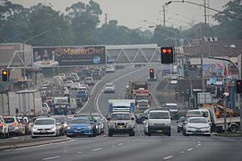 | |
Pennant Hills Road at Thornleigh in 2016 | |
 | |
 Pennant Hills Road | |
| Coordinates | |
| General information | |
| Type | Highway |
| Length | 15 km (9.3 mi) |
| Route number(s) | (Wahroonga-North Parramatta) |
| Former route number | see Former route allocations |
| Major junctions | |
| North end | Wahroonga, Sydney |
| |
| SW end | Church Street Parramatta, Sydney |
| Location(s) | |
| Major suburbs | Wahroonga, Normanhurst, Thornleigh, Pennant Hills, Carlingford, Parramatta |
| Highway system | |

The Pennant Hills Road, a 15-kilometre (9.3 mi) section of the Cumberland Highway (A28), is a major urban highway located in Sydney, New South Wales, Australia. The road links the suburb of Wahroonga in the northeast, to the major central business district of Parramatta in the southwest.
In 2015 NRMA members voted the Pennant Hills Road as the second worst road in New South Wales and the Australian Capital Territory, with approximately 5,000 heavy vehicle movements per day.[1] The NorthConnex, a 9-kilometre (5.6 mi) motorway tunnel opened on 31 October 2020, runs parallel to Pennant Hills Road and links the M2 Hills Motorway at West Pennant Hills with the Pacific Highway and Pacific Motorway at Wahroonga. The NorthConnex aims to reduce congestion and improve traffic flow along part of the Pennant Hills Road, reducing air and traffic pollution.[2]
Route description[]
The road begins in the northern suburb of Wahroonga at Pearce's Corner, the intersection with the Pacific Highway, north-west of the Sydney CBD, and south-east of Hornsby. The Pacific Motorway (M1) ends a few hundred metres south of Pearce's Corner at an intersection with Pennant Hills Road. From here, the road passes through the Hornsby Shire suburbs of Normanhurst, Thornleigh and Pennant Hills. In Thornleigh there is a major intersection with The Comenarra Parkway, an arterial road which begins as Yanko Road in West Pymble. In the evening this intersection can get quite busy, and is often characterised by bumper to bumper traffic on the Comenarra Parkway, as motorists attempt to turn either left or right onto Pennant Hills Road. The Parkway has become somewhat of a through route from the North Shore suburbs as well as the City, with some motorists choosing to avoid Epping Road and The M2 Motorway and travel west through the Parkway.
At Pennant Hills, the highway crosses the Northern Railway Line, intersects with Yarrara Road and Boundary Road, heading west, after which is located a major intersection with Beecroft Road. The highway then heads west, and then south-west towards Thompson's Corner, in West Pennant Hills, where there is a major intersection with Castle Hill Road. In the mid 1990s, a tunnel was built beneath the intersection which allows traffic from Castle Hill Road to turn onto Pennant Hills Road, going southbound, without negotiating the traffic lights. This also means that southbound traffic already on Pennant Hills Road rarely has to stop at the Thompson's Corner intersection, only if pedestrians are crossing.
The highway continues south to the M2 Hills Motorway intersection. Traffic can enter the motorway from Pennant Hills Road to drive either eastbound (towards the City) or westbound (towards Blacktown and Canberra) - as well, motorway traffic is able to exit onto Pennant Hills Road from both directions.
Pennant Hills Road continues south from the M2 intersection through Carlingford and the intersection with and then onto the intersection with . South of the Carlingford Road intersection lies the intersection with Marsden Road, and the highway then continues south-west towards Parramatta, crossing the Carlingford Railway Line, and through the suburbs of Telopea and North Parramatta, where the major intersection with James Ruse Drive lies. Pennant Hills Road forms part of the Cumberland Highway until the intersection with James Ruse Drive where it relinquishes that designation to the latter road.[3]
The highway then continues south-west into Parramatta where it meets Church Street.
The highway is a 60 km/h (37 mph) four-lane road from Pearce's Corner for the short distance to the M1 intersection. From the M1 intersection the highway is a 70 km/h (43 mph) six-lane highway for the entire distance to the M2 Motorway intersection. From here, the road reverts to being a 60 km/h (37 mph) four-lane road for the rest of the distance to Parramatta, with short third lanes at various points in each direction. There are numerous 40 km/h (25 mph) "school zones" (8:00am–9:30am and 2:30pm–4:00pm) and there are two fixed speed cameras, between Evans Road and Coleman Avenue in Carlingford and between Castle Street and Bellevue Street in North Parramatta. Both are 60 km/h (37 mph) zones.[4]
Pennant Hills Road frontage is a mix of businesses, schools and homes. The biggest concentration of businesses are at Thornleigh, Pennant Hills, West Pennant Hills (Thompson's Corner) and Carlingford, with the Carlingford area being the biggest.
History[]
Pennant Hills Road began its life in 1820 as a bullock track used by timbermen. It was surveyed by government surveyor James Meehan in order to provide a route from Ermington Wharf to the Pennant Hills sawmill established by Governor Lachlan Macquarie in 1816. Subsequently, it joined the Lane Cove Road (now the Pacific Highway) further north and was sometimes considered the same road. It has been allocated several route numbers over the years, shown in the Infobox on the right.
Traffic congestion[]
Pennant Hills Road has always been the main road north from Parramatta to Hornsby, but with traffic from major arterial roads of James Ruse Drive, Marsden Road, Carlingford Road, North Rocks Road, Castle Hill Road, Beecroft Road, The Comenarra Parkway and the Pacific Highway adding to that, plus the relatively recent additions of the M2 Motorway and the M1 Motorway extension to Wahroonga, the highway can get quite congested during the morning and afternoon peaks and is often characterised by the heavy population of trucks and other logistic vehicles. Pennant Hills Road is the only direct road linking the M1 and the M2, forcing interstate commercial traffic, travellers, and commuters to all compete for passage with local Hornsby Shire traffic. The average traffic flow on Pennant Hills Rd, according to a 2002 survey by the RTA, was 62,656, with the busiest area occurring around Thompsons Corner.
Plans to link the M1 with a planned North West Freeway were shelved in the late 20th century. Recently the Government has been examining a number of options to link the M1 with the M2 motorway as part of a motorway standard Sydney Bypass.
After undergoing significant studies, the government released plans to construct the M1-M2 link, dubbed the NorthConnex, a tunnel linking the two motorways. Opened on 31 October 2020, the NorthConnex will help alleviate traffic travelling between Western Sydney and the Central Coast.
Pennant Hills Road regulation[]
Since the opening of NorthConnex on 31 October 2020, a fine of A$194 with no demerit points will be imposed on truck and bus drivers who use the Pennant Hills Road instead of the new tolled tunnel, detected using gantries on either side of Pennant Hills Road.[5] The fine only applies to drivers of trucks and buses over 12.5 metres long or over 2.8 metres clearance height, with the exception of vehicles transporting dangerous goods and oversize vehicles approved to use Pennant Hills Road.
Former route allocations[]
Pennant Hills Road has many former route allocations sine 1964. Where and when the former route numbers were implemented are stated below.
Wahroonga - West Pennant Hills
 Ring Road 5 (1964-1974)
 State Route 55 (1974-1988)
 State Route 77 (1988-1993)
 Metroad 7 (1993-2013)
 A28 2013-present)
Pennant Hills - West Pennant Hills
- Ring Road 5 (1964-1974)
- State Route 55 (1974-1988)
- State Route 77 (1988-1993)
- Metroad 7 (1993-2013)
 State Route 30 (1974-1993)
 Metroad 2 (1993-1997)
- A28 2013-present)
West Pennant Hills - Carlingford
- Ring Road 5 (1964-1974)
- State Route 55 (1974-1988)[6]
- State Route 77 (1988-1993)
- Metroad 7 (1993-2005)
 Metroad 6 (2005-2013)
- A28 2013-present)
Carlingford - North Parramatta
- Ring Road 5 (1964-1974)
- State Route 55 (1974-1988)[6]
- State Route 77 (1988-1993)
- Metroad 7 (1993-2005)
- unallocated (2005-2013)
- A28 2013-present)
North Parramatta - Parramatta
- Ring Road 5 (1964-1974)
- State Route 55 (1974-1988)[6]
- unallocated (1988-present)
Gallery[]
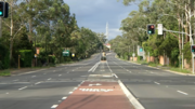
The Pennant Hills road ,Cardinal avenue Intersection, with cars edited out

See also[]
References[]
- ^ Vaughan, Craig (28 October 2015). "Pennant Hills Rd was voted the second worst road in NSW and the ACT in the NRMA's annual survey". Hornsby Advocate. Retrieved 23 October 2016.
- ^ "Frequently asked questions - NorthConnex". www.northconnex.com.au. Retrieved 9 October 2020.
- ^ "NSW METROAD 7 Hornsby to Carlingford", OZROADS: The Australian Roads Website Accessed 26 September 2006[self-published source]
- ^ "Speed camera locations - List of fixed speed camera locations in NSW", Roads and Traffic Authority, NSW Accessed 28 September 2006
- ^ "Pennant Hills Road regulation". Transport for NSW - Roads and Maritime. Archived from the original on 29 October 2020. Retrieved 30 October 2020.
- ^ a b c Former NSW State Route 55, Ozroads, Retrieved on 10 June 2013.[self-published source]
External links[]
- Highways in Sydney
- Streets in Sydney
- The Hills Shire