A6 (Sydney)
This article needs additional citations for verification. (August 2008) |
A6 | |
|---|---|
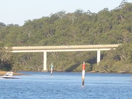 | |
| Alfords Point Bridge | |
| General information | |
| Type | Highway |
| Length | 41.1 km (26 mi) |
| Route number(s) | |
| Former route number |
|
| Major junctions | |
| North end | Carlingford, Sydney |
| |
| South end | Heathcote, Sydney |
| Location(s) | |
| Major suburbs | Eastwood, Ermington, Silverwater, Auburn, Lidcombe, Chullora, Bankstown, Alfords Point, Menai, Barden Ridge, Lucas Heights |
| Highway system | |
The A6 is an arterial road linking Cumberland Highway at Carlingford and Princes Highway at Heathcote, via Lidcombe and Bankstown.[1] It was formerly designated as Metroad 6, which was one of the Sydney Metroads.
The A6 provides a link from the northern suburbs to the southern suburbs, and from the Pacific Highway to the Princes Highway. Some stretches such as Silverwater Road, Alfords Point Road, New Illawarra Road and Heathcote Road have very few junctions or are in (currently) rural areas, and the speed limit is therefore relaxed slightly.
The A6 includes two major bridges - the Silverwater Bridge over the Parramatta River, and the Alfords Point Bridge over Georges River.
Roads[]
Route "A6" consists of all or part of the following roads:[2]
- Marsden Road
- Stewart Street
- Kissing Point Road
- Silverwater Road
- St. Hilliers Road
- Boorea Street
- Olympic Drive
- Joseph Street
- Rookwood Road
- Stacey Street
- Fairford Road
- Davies Road
- Alfords Point Road
- New Illawarra Road
- Heathcote Road
History[]
The earliest route designation of what is now the A6 was as State Route 45. It was introduced in 1974, with the route going from Victoria Road in Ermington to Princes Highway in Heathcote.[3] State Route 45 underwent several realignments. The Lidcombe bypass opened in 1982 and State Route 45 was rerouted onto the bypass. In 1996, the Silverwater Road extension opened and State Route 45 was extended to Pennant Hills Road (Cumberland Highway). In 1999 Stacey Street was extended north to directly connect with Rookwood Rd, obviating the need for State Route 45 traffic to use the Hume Highway between these two roads.
State Route 45 was replaced by Metroad 6 in January 1999. The northern terminus of Metroad 6 was the Marsden Rd/Pennant Hills Road intersection in Carlingford. When the then Metroad 7 was reassigned from Cumberland Highway to the Westlink M7 motorway when it was opened in December 2005, Metroad 6 was extended northwards to the M2 Hills Motorway.
Metroad 6 was realigned between Menai and Barden Ridge, from Old Illawarra Road onto New Illawarra Road, which was completed between 2005 and 2011 as part of the Bangor Bypass project.[4]
In 2013, as part of the introduction of the New South Wales alphanumeric route numbering scheme, Metroad 6 was dedesignated. The Pennant Hills Road section of Metroad 6 was redesignated as part of route A28 in May–June 2013, while the rest of the Metroad 6 designation was replaced by the A6 designation in August–October 2013.
Future[]
In 2019, the New South Wales Government announced it would rename the northern extension of the Princes Motorway, between Arncliffe and Kogarah (due to open in 2025) to the "M6 Motorway".[5] No announcement has yet been made on whether the A6 will be renumbered to avoid duplicate numbers.
See also[]
Route map:

| ( • help)
|
![]() Australian Roads portal
Australian Roads portal
References[]
- ^ "A GUIDE TO SYDNEY'S TOLL ROADS" (PDF). NRMA Motoring and Services. Retrieved 14 March 2012.
- ^ "Spatial Information Exchange". New South Wales Land and Property Information.
- ^ State Route 45, Ozroads, Retrieved on 2 August 2013.[self-published source]
- ^ "Bangor Bypass Stage 1 and 2" (PDF). Roads and Traffic Authority. Archived from the original (PDF) on 25 August 2006. Retrieved 25 June 2019.
- ^ O'Sullivan, Matt (29 October 2019). "Opening of new motorway in Sydney's south running 12 months late". Sydney Morning Herald. Nine Entertainment Co. Retrieved 2 February 2020.
- Sydney Metroads