Plumville, Pennsylvania
Plumville, Pennsylvania | |
|---|---|
Borough | |
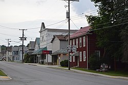 Main Street | |
 Location of Plumville in Indiana County, Pennsylvania. | |
 Plumville Location of Plumville in Indiana County, Pennsylvania. | |
| Coordinates: 40°47′38″N 79°10′49″W / 40.79389°N 79.18028°WCoordinates: 40°47′38″N 79°10′49″W / 40.79389°N 79.18028°W | |
| Country | United States |
| State | Pennsylvania |
| County | Indiana |
| Government | |
| • Type | Borough Council |
| Area | |
| • Total | 0.50 sq mi (1.28 km2) |
| • Land | 0.50 sq mi (1.28 km2) |
| • Water | 0.00 sq mi (0.00 km2) |
| Population (2010) | |
| • Total | 307 |
| • Estimate (2019)[2] | 287 |
| • Density | 578.63/sq mi (223.57/km2) |
| Time zone | UTC-5 (Eastern (EST)) |
| • Summer (DST) | UTC-4 (EDT) |
| Zip code | 16246 |
| FIPS code | 42-61632 |


Plumville is a borough in Indiana County, Pennsylvania, United States. The population was 307 at the 2010 census.
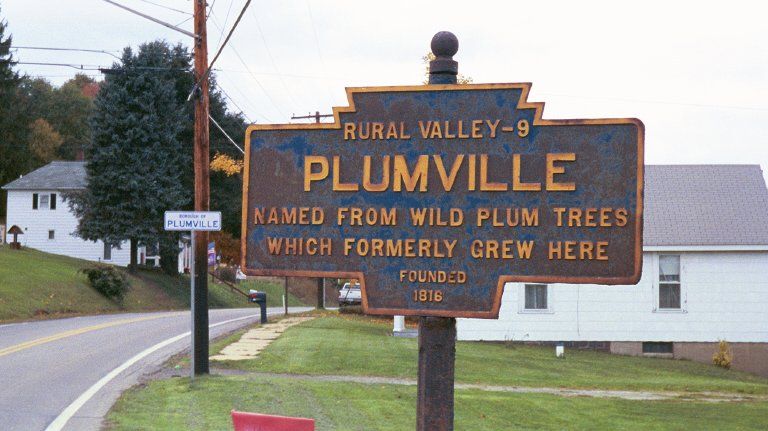
The borough was originally named for the presence of wild plum trees.[3]
Geography[]
Plumville is located at 40°47′38″N 79°10′49″W / 40.79389°N 79.18028°W (40.793823, -79.180235).[4]
According to the United States Census Bureau, the borough has a total area of 0.5 square miles (1.3 km2), all of it land.
Demographics[]
| Historical population | |||
|---|---|---|---|
| Census | Pop. | %± | |
| 1880 | 191 | — | |
| 1910 | 414 | — | |
| 1920 | 538 | 30.0% | |
| 1930 | 518 | −3.7% | |
| 1940 | 469 | −9.5% | |
| 1950 | 452 | −3.6% | |
| 1960 | 401 | −11.3% | |
| 1970 | 429 | 7.0% | |
| 1980 | 431 | 0.5% | |
| 1990 | 390 | −9.5% | |
| 2000 | 342 | −12.3% | |
| 2010 | 307 | −10.2% | |
| 2019 (est.) | 287 | [2] | −6.5% |
| Sources:[5][6][7] | |||
As of the census[6] of 2000, there were 342 people, 123 households, and 92 families residing in the borough. The population density was 673.3 people per square mile (258.9/km2). There were 145 housing units at an average density of 285.4 per square mile (109.8/km2). The racial makeup of the borough was 98.54% White, 0.29% Native American, and 1.17% from two or more races.
There were 123 households, out of which 34.1% had children under the age of 18 living with them, 62.6% were married couples living together, 7.3% had a female householder with no husband present, and 24.4% were non-families. 22.0% of all households were made up of individuals, and 9.8% had someone living alone who was 65 years of age or older. The average household size was 2.78 and the average family size was 3.23.
In the borough the population was spread out, with 28.9% under the age of 18, 8.5% from 18 to 24, 28.7% from 25 to 44, 21.6% from 45 to 64, and 12.3% who were 65 years of age or older. The median age was 33 years. For every 100 females there were 100.0 males. For every 100 females age 18 and over, there were 100.8 males.
The median income for a household in the borough was $26,964, and the median income for a family was $28,125. Males had a median income of $24,792 versus $20,625 for females. The per capita income for the borough was $14,540. About 22.7% of families and 29.5% of the population were below the poverty line, including 44.9% of those under age 18 and 25.6% of those age 65 or over.
References[]
- ^ "2019 U.S. Gazetteer Files". United States Census Bureau. Retrieved July 28, 2020.
- ^ Jump up to: a b "Population and Housing Unit Estimates". United States Census Bureau. May 24, 2020. Retrieved May 27, 2020.
- ^ A picture of the Pennsylvania name marker
- ^ "US Gazetteer files: 2010, 2000, and 1990". United States Census Bureau. 2011-02-12. Retrieved 2011-04-23.
- ^ "Census of Population and Housing". U.S. Census Bureau. Retrieved 11 December 2013.
- ^ Jump up to: a b "U.S. Census website". United States Census Bureau. Retrieved 2008-01-31.
- ^ "Incorporated Places and Minor Civil Divisions Datasets: Subcounty Resident Population Estimates: April 1, 2010 to July 1, 2012". Population Estimates. U.S. Census Bureau. Archived from the original on 17 June 2013. Retrieved 11 December 2013.
| show Municipalities and communities of Indiana County, Pennsylvania, United States |
|---|


| show Authority control |
|---|
- Populated places established in 1816
- Boroughs in Indiana County, Pennsylvania