Dahod district
Dahod district
Dohad | |
|---|---|
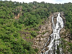 Ratanmahal falls | |
 Location of district in Gujarat | |
| Country | |
| State | Gujarat |
| Collector & DM | Dr. Harshit Gosavi I.A.S. |
| Headquarters | Dahod |
| Area | |
| • Total | 3,642 km2 (1,406 sq mi) |
| Population (2011) | |
| • Total | 2,127,086 |
| • Density | 580/km2 (1,500/sq mi) |
| Languages | |
| • Official | Gujarati, Hindi, English |
| Time zone | UTC+5:30 (IST) |
| Vehicle registration | GJ 20 |
| Website | dahod |
Dahod district is a district of Gujarat state in western India. This largely tribal district is mostly covered by forests and hills.
Geography[]
Dahod is located in eastern Gujarat. It is located at the tripoint between Gujarat, Rajasthan and Madhya Pradesh. It borders Rajasthan to the north, Madhya Pradesh to the east, Chhota Udaipur district to the south, Panchmahal district to the west and Mahisagar district to the north. The district has two areas: a region of scrubland in the western part of the district and hills in the east. All these areas are covered by forests. The district has several rivers flowing through it: the Panam, Khan, Kalutari, Machhan and Anas. These rivers are tributaries of the Mahi.
History[]
The name "Dohad" means "two borders" due to its location on the border between the regions of Gujarat, Malwa and Wagad (in Rajasthan). According to folklore, Rishi Dadhichi once meditated at the banks of Dudhimati River in Dahod.
Siddaraj Jaisingh of the Chaulukya Dynasty invaded Dahod in 1036 CE and camped there for 12 years. Dahod was a historical fort from the Mughal period. Aurangzeb was born at Dahod fort in 1658.
During the Rebellion of 1857, Tatya Tope attacked Dahod. The British leased Dahod, along with the rest of Panch Mahal from the Scindias of Gwalior for seven years and then exchanged it for another district in 1890. Dahod was carved out of Panchmahal district in 1997.
Demographics[]
| Year | Pop. | ±% p.a. |
|---|---|---|
| 1901 | 177,555 | — |
| 1911 | 229,553 | +2.60% |
| 1921 | 267,075 | +1.53% |
| 1931 | 317,838 | +1.76% |
| 1941 | 365,700 | +1.41% |
| 1951 | 437,189 | +1.80% |
| 1961 | 580,397 | +2.87% |
| 1971 | 742,363 | +2.49% |
| 1981 | 946,588 | +2.46% |
| 1991 | 1,274,123 | +3.02% |
| 2001 | 1,636,433 | +2.53% |
| 2011 | 2,127,086 | +2.66% |
| source:[1] | ||
It was 8.99% urban at the 2001 census.[2] The population of the district is mostly rural, and a majority of the district's residents are tribals, mostly Bhils. Dahod District also has the second largest population of the Dawoodi Bohra sect of Ismā'īlī Muslims in India.
At the 2011 census Dahod District had a population of 2,127,086,[3] roughly equal to the nation of Namibia[4] or the US state of New Mexico.[5] It was the 215th most populous district in India (out of a total of 640).[3] The district had a population density of 582 inhabitants per square kilometre (1,510/sq mi).[3] Its population growth rate over the decade 2001–2011 was 29.95%.[3] It had a sex ratio of 986 females for every 1000 males,[3] and a literacy rate of 60.6%. Scheduled Castes and Scheduled Tribes make up 1.95% and 74.32% of the population respectively.[3]
At the time of the 2011 Census of India, 96.29% of the population in the district spoke Gujarati, 2.14% Bhili and 1.18% Hindi as their first language.[7]
Education[]
There is a government polytechnic college since 1963 and it was started by Indian prime minister Mr. Moraraji Desai and now government degree engineering college[8] is also there. The degree college is affiliated to Gujarat University.
Economy[]
In 2006, the Ministry of Panchayati Raj named Dahod one of the country's 250 most backward districts (out of a total of 640).[9] It is one of the six districts in Gujarat currently receiving funds from the Backward Regions Grant Fund Programme (BRGF).[9]
Ratan Mahal Sanctuary[]
It is a mixed, deciduous forest, located at Gujarat's border with Madhya Pradesh, within the Khathiar-Gir dry deciduous forests' ecoregion.[10] The maximum area covered is in Gujarat. Ratanmahal Sanctuary is near by River Paanam (a major river of Central Gujarat), which helps to preserve the ecological balance in the forest, besides water conservation. The sanctuary is also known as "Ratanmahal Sloth Bear Sanctuary," due to its sloth bear population.[11] As with Purna Wildlife Sanctuary, Ratanmahal has experienced extinctions in its population of birds.[12]
See also[]
- Forest of the Dangs
- Jessore Sloth Bear Sanctuary
- Shoolpaneshwar Wildlife Sanctuary
References[]
- ^ Decadal Variation In Population Since 1901
- ^ "India Map". Archived from the original on 2007-07-03. Retrieved 2009-08-27.
- ^ a b c d e f "Gujarat Distrct Census - Dohad" (PDF). Office of the Registrar General & Census Commissioner, India.
- ^ US Directorate of Intelligence. "Country Comparison:Population". Retrieved 2011-10-01.
Namibia – 2,147,585
- ^ "2010 Resident Population Data". U.S. Census Bureau. Archived from the original on 2013-10-19. Retrieved 2011-09-30.
New Mexico – 2,059,179
- ^ "C-16 Population By Religion - Gujarat". census.gov.in. Office of the Registrar General & Census Commissioner, India.
- ^ 2011 Census of India, Population By Mother Tongue
- ^ "Archived copy". Archived from the original on 2012-05-02. Retrieved 2019-11-19.
{{cite web}}: CS1 maint: archived copy as title (link) - ^ a b Ministry of Panchayati Raj (September 8, 2009). "A Note on the Backward Regions Grant Fund Programme" (PDF). National Institute of Rural Development. Archived from the original (PDF) on April 5, 2012. Retrieved September 27, 2011.
- ^ "Khathiar-Gir dry deciduous forests". Terrestrial Ecoregions. World Wildlife Fund. Retrieved 2017-02-14.
- ^ Garshelis, David L.; Joshi, Anup R.; Smith, James L. D. & Rice, Clifford G. "Sloth Bear Conservation Action Plan" (PDF). Archived from the original (PDF) on 23 July 2011. Retrieved 18 April 2011.
- ^ "Significant bird records and local extinctions in Purna and Ratanmahal Wildlife Sanctuaries, Gujarat, India-PRANAV TRIVEDI and V. C. SONI" (PDF). Archived from the original (PDF) on 2017-08-10. Retrieved 2019-06-18.
External links[]
| Wikimedia Commons has media related to Dahod district. |
Places adjacent to Dahod district | |
|---|---|
| Topics |
|  |
|---|---|---|
| Regions of Gujarat | ||
| Districts | ||
| Major cities | ||
| Ecoregions | ||
| Economy |
| |
| ||
Authority control | |
|---|---|
| General |
|
| National libraries | |
Coordinates: 22°50′02″N 74°15′28″E / 22.83389°N 74.25778°E
- Dahod district
- Districts of Gujarat
- 1997 establishments in Gujarat