Rohy
Rohy | |
|---|---|
Municipality | |
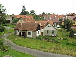 Central part of the village | |
 Flag  Coat of arms | |
 Rohy | |
| Coordinates: 49°18′37″N 16°0′17″E / 49.31028°N 16.00472°ECoordinates: 49°18′37″N 16°0′17″E / 49.31028°N 16.00472°E | |
| Country | Czech Republic |
| Region | Vysočina |
| District | Třebíč |
| Area | |
| • Total | 6.39 km2 (2.47 sq mi) |
| Elevation | 473 m (1,552 ft) |
| Population (2006) | |
| • Total | 124 |
| • Density | 19/km2 (50/sq mi) |
| Postal code | 675 04 |
| Website | http://www.obecrohy.cz/ |

Rohy is a village and municipality (obec) in Třebíč District in the Vysočina Region of the Czech Republic.
The municipality covers an area of 6.39 square kilometres (2.47 sq mi), and has a population of 124 as of 3 July 2006.
Rohy lies approximately 14 kilometres (9 mi) north-east of Třebíč, 32 km (20 mi) east of Jihlava, and 143 km (89 mi) south-east of Prague.
External links[]
| Authority control: National libraries |
|---|
This Vysočina Region location article is a stub. You can help Wikipedia by . |
Categories:
- Villages in Třebíč District
- Vysočina Region geography stubs