Rokycany
Rokycany | |
|---|---|
 Historical centre | |
 Flag  Coat of arms | |
 Rokycany Location in the Czech Republic | |
| Coordinates: 49°44′33″N 13°35′44″E / 49.74250°N 13.59556°ECoordinates: 49°44′33″N 13°35′44″E / 49.74250°N 13.59556°E | |
| Country | |
| Region | Plzeň |
| District | Rokycany |
| First mentioned | 1110 |
| Government | |
| • Mayor | Václav Kočí |
| Area | |
| • Total | 30.67 km2 (11.84 sq mi) |
| Elevation | 362 m (1,188 ft) |
| Population (2021-01-01)[1] | |
| • Total | 14,313 |
| • Density | 470/km2 (1,200/sq mi) |
| Time zone | UTC+1 (CET) |
| • Summer (DST) | UTC+2 (CEST) |
| Postal code | 337 01 |
| Website | www |

Rokycany (Czech pronunciation: [ˈrokɪtsanɪ]; German: Rokitzan) is a town in the Plzeň Region of the Czech Republic. It has about 14,000 inhabitants. The town centre is well preserved and is protected by law as an urban monument zone.
Administrative parts[]
Rokycany is made up of town parts of Střed ("Centre"), Nové Město ("New Town") and Plzeňské předměstí ("Plzeň Suburb"), and village of Borek.
Geography[]

Rokycany lies 17 km (11 mi) east of the region capital Plzeň on the confluence of the Klabava River and the Holoubkovský Brook. There is another smaller brook (Rakovský Brook) in the western part of the town.
The largest water area is Klabava Reservoir with an area of 128 ha. Today it serves as flood protection and as a recreational area.[2] The second notable water area is Borecký Pond.
The town lies in the lowland, 362 metres (1,188 ft) above sea level, bordered by hilly woodlands, especially the Brdy mountains to the east and the Radeč massif. The highest point of the municipal territory is Čilina hill with 523 m (1,716 ft) above sea level.
History[]


The place was inhabited since the Stone Age. Celtic and early Slavic settlements were discovered. The first written mention of Rokycany is from Chronica Boemorum from 1110. At that time the village was owned by the Bishop of Prague, and major Bohemian and German noblemen met here for diplomatic talks with Emperor Henry V.[3]
At the end of the 13th century, bishop Tobiáš of Bechyně made from the settlement a market town and the episcopal court was replaced by episcopal castle. In the 14th century the town fortification was made, few its fragments are preserved to this day. In 1406 Rokycany obtained town privileges. The town was a property of church until Hussite Wars. In 1421 the town was conquered by Jan Žižka's army, but later that year it was conquered, burned and looted by Plzeň's Catholics.[3]
In 1436–1498 Rokycany was owned by Lords of Švamberk and in 1498 it was bought by Vladislaus II. In 1584, it was promoted by Emperor Rudolf II to a royal town. The prosperity came to an abrupt end with the Thirty Years' War. Rokycany was repeatedly afflicted by various armies, most notably by the Swedish who almost completely burned the town. The town was among the most destroyed Bohemian towns. Thanks to the ironworks and woodworking industry, the town began to flourish again. However, two huge fires in 1757 and 1784 deprived the town of its medieval character. Almost everything was destroyed, including municipal buildings, the town hall and the church.[3]
Thanks to favorable economic conditions of the residents the post-1784 renewal proceeded rather quickly. In the 1840s, it again became one of the most richest Bohemian towns. In the 19th century the traditional iron-ore mining and processing industry became main source of Rokycany's economy. In 1862 Rokycany was connected via railway with Prague and Plzeň. Industrial development continued for most of the 20th century.[3]
On May 7, 1945 Rokycany was liberated by the United States Army which halted its eastward advance here, meeting with the allied Soviet troops in the eastern part of the town (creating so-called Demarcation line). It was the very first meeting of United States Army and Soviet Army.[3]
In the post-World War II era, the development of the town was carried out in line with the ruling communist regime. The new massive construction activity focused on uniform tenement houses, from 1960s built with concrete panels (so-called "panelák"). The local industry was further expanded and the life of the town was strongly influenced by strong army garrison (located in two barracks built in 1899 and 1933 respectively). In 1960 neighbouring municipality of Borek was merged with Rokycany, in 1980 another three municipalities (Kamenný Újezd, Svojkovice and Litohlavy) joined Rokycany (however the first two have separated in 1990 and Litohlavy in 1994).[4]
Demography[]
|
|
| ||||||||||||||||||||||||||||||||||||||||||||||||||||||
| Source: Historical lexicon of municipalities of the Czech Republic[5] | ||||||||||||||||||||||||||||||||||||||||||||||||||||||||
In 19th century Rokycany's population quickly expanded pushing the number of inhabitants towards 5,000 in 1880. In the wake of Long Depression (economic slowdown of the 1870s which affected the economy of Austria-Hungary) the growth stopped. In late 1890s however population began to expand again, only to halt during World War I. In post-1918 era Rokycany grew rapidly. In the late 1930s this growth was further spurred by influx of ethnic Czech refugees from Sudetenland. In 1939 Rokycany's population touched 10,000 mark briefly. After World War II many citizens of Rokycany left the town for border regions from where the ethnic Germans were expelled. From the 1950s a new wave of massive growth started, pushing the town's population past 10,000 in the mid 1950s and past 15,000 in the 1980s. Demographic maximum was reached in 1989 with more than 16,000 inhabitants. Since that time the population dropped to c. 14,000 as a result of economic a social transition and also of separation of 3 municipalities from Rokycany.
Ethnically, Rokycany has been a predominately Czech settlement since Middle Ages. The German minority accounted for no more than couple of dozens individuals. In 1938 the town's population was boosted by influx of ethnic Czechs fleeing the border regions of Czechoslovakia which had been ceded to Nazi Germany. After 1945 most ethnic Germans were expelled. The ethnic mix of Rokycany was in the post-World War II era enriched by Romani and Slovaks.
Sights[]


The Masarykovo Square is in the historical core of Rokycany and contains most of town's cultural monuments. The town hall is a Baroque building by architect from 1804–1808. The stone Baroque fountain from 1827 stands in front of the so-called "Rokycan's House of Enlightenment". In the half of the 19th century, this Neo-Renaissance building and the town hall were two only two-storey houses in the square.[6]
The Church of Saint Mary Major is located in the northeastern part of the square. It stands on the place of the episcopal court, mentioned already in 1110.[6] It was built in the 14th century in Gothic style. After a large fire, it was rebuilt by Palliardi in 1785–1788.[7]
The Dumet's House next to the church was first mentioned in 1512, however it probably exists much longer. In 1784–1787 it served as a school, but it was burned down by a fire. Nowadays it has a Rococo façade with stucco decoration.[6]
Transport[]
The town is located on a train line leading from Prague to Plzeň. There is a train station which is served by regional and longer-distance trains.
Culture[]
Rokycany hosts Fluff Fest, a vegan hardcore punk festival which draws several thousand visitors from across Europe every July. It is held at the Rokycany airfield, having moved there in 2006 from its original location in Plzeň. The festival has been described as a yearly "strain" on the town, which is otherwise unaccustomed to large numbers of foreign visitors and extreme music adherents, and brings a business boom especially in sales of vegetarian and vegan food.[8]
Notable people[]
- John of Rokycan (c.1396–1471), archbishop of Prague
- Antonín Kraft (1749–1820), cellist and composer
- Adolf Kraus (1850–1928), Chicago lawyer, B'nai B'rith officer, lived here
- Paula Deppe (1886–1922), Sudeten German painter
- Čestmír Řanda (1923–1986), actor
- Věra Bílá (1954–2019), singer
- Jiří Pehe (born 1955), political analyst and writer
- Jaroslav Špaček (born 1974), ice hockey player
- Vhrsti (born 1975), illustrator
- Václav Procházka (born 1984), footballer
Twin towns – sister cities[]
Gallery[]

Town hall and main square
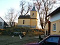
Chapel in Borek
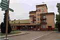
Railway station from 1931

1970's style houses

1930s army barracks


References[]
- ^ "Population of Municipalities – 1 January 2021". Czech Statistical Office. 2021-04-30.
- ^ "Vodní nádrž Klabava". Atlas Česka. Retrieved 2021-06-17.
- ^ Jump up to: a b c d e "Historie města". Město Rokycany. Retrieved 2021-06-17.
- ^ "Dějiny Rokycan 1951–2000" (in Czech). Město Rokycany. Retrieved 2021-06-17.
- ^ "Historický lexikon obcí České republiky 1869–2011 – Okres Rokycany" (in Czech). Czech Statistical Office. 2015-12-21. pp. 5–6.
- ^ Jump up to: a b c "Památky". Město Rokycany. Retrieved 2021-06-17.
- ^ "Kostel Panny Marie Sněžné". Hrady.cz. Retrieved 2021-06-17.
- ^ Vaníková, Jana (26 July 2015). "Fluff fest, to je nápor na Rokycany" [Fluff Fest is a strain on Rokycany] (in Czech). Rokycanský deník. Retrieved 9 October 2017.
- ^ "Partnerská města". Město Rokycany. Retrieved 2021-06-17.
External links[]
| Wikimedia Commons has media related to Rokycany. |
| show Authority control |
|---|
- Cities and towns in the Czech Republic
- Populated places in Rokycany District