Saint-Gabriel-Lalemant, Quebec
Saint-Gabriel-Lalemant | |
|---|---|
Municipality | |
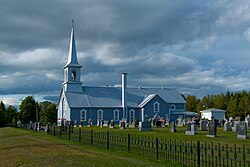 Saint-Gabriel-Lalemant Church | |
 Location within Kamouraska RCM | |
 Saint-Gabriel-Lalemant Location in eastern Quebec | |
| Coordinates: 47°23′N 69°56′W / 47.383°N 69.933°WCoordinates: 47°23′N 69°56′W / 47.383°N 69.933°W[1] | |
| Country | |
| Province | |
| Region | Bas-Saint-Laurent |
| RCM | Kamouraska |
| Constituted | May 27, 1939 |
| Government | |
| • Mayor | Raymond Chouinard |
| • Federal riding | Montmagny—L'Islet—Kamouraska—Rivière-du-Loup |
| • Prov. riding | Côte-du-Sud |
| Area | |
| • Total | 78.80 km2 (30.42 sq mi) |
| • Land | 77.31 km2 (29.85 sq mi) |
| Population | |
| • Total | 799 |
| • Density | 10.3/km2 (27/sq mi) |
| • Pop 2006-2011 | |
| • Dwellings | 405 |
| Time zone | UTC−5 (EST) |
| • Summer (DST) | UTC−4 (EDT) |
| Postal code(s) | G0L 3E0 |
| Area code(s) | 418 and 581 |
| Highways | No major routes |
| Website | www |

Saint-Gabriel-Lalemant is a municipality in the Canadian province of Quebec, located in the Kamouraska Regional County Municipality. The municipality is named for St. Gabriel Lalemant, one of the Canadian Martyrs.
Municipal council[]
- Mayor: Raymond Chouinard
- Councillors: Alain Danjou, Jean-Yves Danjou, Michel Larose, Marc-André Lévesque, Denis Milliard, Jean-Paul Milliard
See also[]
References[]
- ^ Reference number 184464 of the Commission de toponymie du Québec (in French)
- ^ Jump up to: a b Geographic code 14075 in the official Répertoire des municipalités (in French)
- ^ Jump up to: a b "(Code 2414075) Census Profile". 2011 census. Statistics Canada. 2012.
External links[]
 Media related to Saint-Gabriel-Lalemant, Quebec at Wikimedia Commons
| show Adjacent Municipal Subdivisions |
|---|
| hide | |
|---|---|
| Cities and towns | |
| Municipalities | |
| Parishes |
|
| Unorganized territories | |
| |
| show Authority control |
|---|
This Bas-Saint-Laurent location article is a stub. You can help Wikipedia by . |
Categories:
- Municipalities in Quebec
- Incorporated places in Bas-Saint-Laurent
- Bas-Saint-Laurent geography stubs