Saint-Séverin, Chaudière-Appalaches, Quebec
Saint-Séverin | |
|---|---|
Parish municipality | |
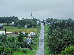 The village core, as seen from Rang 1. | |
 Location within Robert-Cliche RCM. | |
 Saint-Séverin Location in southern Quebec. | |
| Coordinates: 46°19′N 71°03′W / 46.317°N 71.050°WCoordinates: 46°19′N 71°03′W / 46.317°N 71.050°W[1] | |
| Country | |
| Province | |
| Region | Chaudière-Appalaches |
| RCM | Robert-Cliche |
| Constituted | December 24, 1875 |
| Government | |
| • Mayor | Jean-Paul Cloutier |
| • Federal riding | Beauce |
| • Prov. riding | Beauce-Nord |
| Area | |
| • Total | 58.70 km2 (22.66 sq mi) |
| • Land | 58.91 km2 (22.75 sq mi) |
| There is an apparent contradiction between two authoritative sources | |
| Population (2011)[3] | |
| • Total | 266 |
| • Density | 4.5/km2 (12/sq mi) |
| • Pop 2006-2011 | |
| • Dwellings | 162 |
| Time zone | UTC−5 (EST) |
| • Summer (DST) | UTC−4 (EDT) |
| Postal code(s) | G0N 1V0 |
| Area code(s) | 418 and 581 |
| Highways | No major routes |
| Website | www |

Saint-Séverin is a parish in the Robert-Cliche Regional County Municipality in Quebec, Canada. It is part of the Chaudière-Appalaches region and the population is 292 as of 2009. It is named after Reverend Édouard-Séverin Fafard, founder of the parish in 1864.
References[]
- ^ Reference number 57632 of the Commission de toponymie du Québec (in French)
- ^ a b Geographic code 27070 in the official Répertoire des municipalités (in French)
- ^ a b "(Code 2427070) Census Profile". 2011 census. Statistics Canada. 2012.
Places adjacent to Saint-Séverin, Chaudière-Appalaches, Quebec | |
|---|---|
| Cities & Towns | |
|---|---|
| Municipalities | |
| Parishes | |
| Villages | |
| |
Categories:
- Parish municipalities in Quebec
- Incorporated places in Chaudière-Appalaches