Saint-Télesphore, Quebec
Saint-Télesphore | |
|---|---|
Municipality | |
 | |
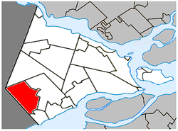 Location within Vaudreuil-Soulanges RCM. | |
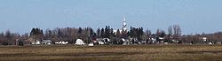
 Saint-Télesphore Location in southern Quebec. | |
| Coordinates: 45°18′N 74°23′W / 45.300°N 74.383°WCoordinates: 45°18′N 74°23′W / 45.300°N 74.383°W[1] | |
| Country | |
| Province | |
| Region | Montérégie |
| RCM | Vaudreuil-Soulanges |
| Constituted | 19 April 1877 |
| Government | |
| • Mayor | Yvon Bériault |
| • Federal riding | Salaberry—Suroît |
| • Prov. riding | Soulanges |
| Area | |
| • Total | 60.80 km2 (23.48 sq mi) |
| • Land | 60.42 km2 (23.33 sq mi) |
| Population (2011)[4] | |
| • Total | 762 |
| • Density | 12.6/km2 (33/sq mi) |
| • Pop 2006-2011 | |
| • Dwellings | 361 |
| Time zone | UTC−5 (EST) |
| • Summer (DST) | UTC−4 (EDT) |
| Postal code(s) | J0P 1Y0 |
| Area code(s) | 450 and 579 |
| Highways | |


Town Hall
Saint-Télesphore is a municipality located in Vaudreuil-Soulanges Regional County Municipality, Quebec (Canada). The population as of the Canada 2011 Census was 762. The municipality is situated west of Saint-Polycarpe and east of the provincial border near North Lancaster, Ontario.
History[]
The municipality is named for Pope Telesphorus, who reigned from 126 to 138 AD.
Demographics[]
Population[]
| hideCanada census – Saint-Télesphore, Quebec community profile | |||
|---|---|---|---|
| 2011 | 2006 | ||
| Population: | 762 (-0.9% from 2006) | 769 (-0.5% from 2001) | |
| Land area: | 60.42 km2 (23.33 sq mi) | 60.42 km2 (23.33 sq mi) | |
| Population density: | 12.6/km2 (33/sq mi) | 12.7/km2 (33/sq mi) | |
| Median age: | 43.1 (M: 43.5, F: 42.3) | 42.4 (M: 41.6, F: 43.1) | |
| Total private dwellings: | 361 | 352 | |
| Median household income: | $47,601 | $37,527 | |
| References: 2011[4] 2006[5] earlier[6] | |||
|
|
|
Language[]
| Canada Census Mother Tongue - Saint-Télesphore, Quebec[7] | ||||||||||||||||||
|---|---|---|---|---|---|---|---|---|---|---|---|---|---|---|---|---|---|---|
| Census | Total | French
|
English
|
French & English
|
Other
| |||||||||||||
| Year | Responses | Count | Trend | Pop % | Count | Trend | Pop % | Count | Trend | Pop % | Count | Trend | Pop % | |||||
2011
|
765
|
655 | 85.62% | 80 | 10.46% | 20 | 2.61% | 10 | 1.31% | |||||||||
2006
|
765
|
630 | 82.35% | 120 | 15.69% | 0 | 0.00% | 15 | 1.96% | |||||||||
2001
|
775
|
660 | 85.16% | 105 | 13.55% | 10 | 1.29% | 0 | 0.00% | |||||||||
1996
|
815
|
730 | n/a | 89.57% | 85 | n/a | 10.43% | 0 | n/a | 0.00% | 0 | n/a | 0.00% | |||||
Education[]
Commission Scolaire des Trois-Lacs operates Francophone schools.[8]
- École du Val-des-Prés Immaculée-Conception
Lester B. Pearson School Board operates Anglophone schools.[9]
- Soulanges Elementary School in Saint-Télesphore or Evergreen Elementary and Forest Hill Elementary (Junior Campus and Senior campus) in Saint-Lazare
See also[]
References[]
- ^ Reference number 57684 of the Commission de toponymie du Québec (in French)
- ^ Jump up to: a b Ministère des Affaires municipales, des Régions et de l'Occupation du territoire: Saint-Télesphore
- ^ Parliament of Canada Federal Riding History: VAUDREUIL--SOULANGES (Quebec)
- ^ Jump up to: a b c "2011 Community Profiles". 2011 Canadian Census. Statistics Canada. 5 July 2013. Retrieved 7 February 2014.
- ^ "2006 Community Profiles". 2006 Canadian Census. Statistics Canada. 30 March 2011. Retrieved 7 February 2014.
- ^ "2001 Community Profiles". 2001 Canadian Census. Statistics Canada. 17 February 2012.
- ^ Jump up to: a b Statistics Canada: 1996, 2001, 2006, 2011 census
- ^ "Les écoles et les centres". Commission Scolaire des Trois-Lacs. Retrieved 18 January 2013.
- ^ "School Board Map." Lester B. Pearson School Board. Retrieved on 28 September 2017.
External links[]
![]() Media related to Saint-Télesphore at Wikimedia Commons
Media related to Saint-Télesphore at Wikimedia Commons
| show Adjacent Municipal Subdivisions |
|---|
| hide | |
|---|---|
| Cities & towns | |
| Municipalities | |
| Villages | |
| |
| show Authority control |
|---|
Categories:
- Municipalities in Quebec
- Incorporated places in Vaudreuil-Soulanges Regional County Municipality