Notre-Dame-de-l'Île-Perrot
Notre-Dame-de-l'Île-Perrot | |
|---|---|
City | |
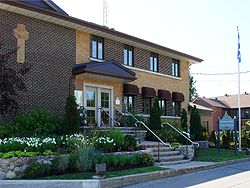 Town hall | |
 Coat of arms | |
 Location within Vaudreuil-Soulanges RCM. | |
 Notre-Dame-de-l'Île-Perrot Location in southern Quebec. | |
| Coordinates: 45°22′N 73°56′W / 45.367°N 73.933°WCoordinates: 45°22′N 73°56′W / 45.367°N 73.933°W[1] | |
| Country | |
| Province | |
| Region | Montérégie |
| RCM | Vaudreuil-Soulanges |
| Constituted | 14 April 1984 |
| Government | |
| • Mayor | Danie Deschênes |
| • Federal riding | Vaudreuil-Soulanges |
| • Prov. riding | Vaudreuil |
| Area | |
| • Total | 65.60 km2 (25.33 sq mi) |
| • Land | 27.80 km2 (10.73 sq mi) |
| Population (2016)[5] | |
| • Total | 10,756 |
| • Density | 386.9/km2 (1,002/sq mi) |
| • Pop 2011-2016 | |
| • Dwellings | 3,768 |
| Time zone | UTC−5 (EST) |
| • Summer (DST) | UTC−4 (EDT) |
| Postal code(s) | J7V |
| Area code(s) | 514 and 438 |
| Highways | No major routes |
| Website | www |

Notre-Dame-de-l'Île-Perrot is the largest of four municipalities located on Île Perrot, west of the island of Montreal, Quebec. The population as of the Canada 2016 Census was 10,654. It hosts the island's first church built in 1740 originally situated at Pointe-du-Moulin which was reconstituted as the Chapelle du Souvenir in 1953 beside the church of Sainte-Jeanne-de-Chantal across from the town hall.
Demographics[]
Population[]
| hideCanada census – Notre-Dame-de-l'Île-Perrot community profile | |||
|---|---|---|---|
| 2011 | 2006 | ||
| Population: | 10,620 (+7.4% from 2006) | 9,885 (+15.7% from 2001) | |
| Land area: | 27.80 km2 (10.73 sq mi) | 27.80 km2 (10.73 sq mi) | |
| Population density: | 382.1/km2 (990/sq mi) | 355.6/km2 (921/sq mi) | |
| Median age: | 39.6 (M: 39.7, F: 39.6) | 37.2 (M: 37.3, F: 37.1) | |
| Total private dwellings: | 3,768 | 3,459 | |
| Median household income: | $92,539 | $82,501 | |
| References: 2011[5] 2006[6] earlier[7] | |||
|
|
|
Language[]
| Canada Census Mother Tongue - Notre-Dame-de-l'Île-Perrot, Quebec[8] | ||||||||||||||||||
|---|---|---|---|---|---|---|---|---|---|---|---|---|---|---|---|---|---|---|
| Census | Total | French
|
English
|
French & English
|
Other
| |||||||||||||
| Year | Responses | Count | Trend | Pop % | Count | Trend | Pop % | Count | Trend | Pop % | Count | Trend | Pop % | |||||
2016
|
10,640
|
6,570 | 61.75% | 2,310 | 21.71% | 210 | 1.97% | 1,380 | 12.96% | |||||||||
2011
|
10,455
|
6,890 | 65.90% | 2,230 | 21.33% | 235 | 2.25% | 1,100 | 10.52% | |||||||||
2006
|
9,865
|
7,035 | 71.31% | 1,980 | 20.07% | 150 | 1.52% | 700 | 7.10% | |||||||||
2001
|
8,530
|
6,375 | 74.74% | 1,525 | 17.88% | 125 | 1.46% | 505 | 5.92% | |||||||||
1996
|
7,020
|
5,375 | n/a | 76.57% | 1,245 | n/a | 17.73% | 105 | n/a | 1.50% | 295 | n/a | 4.20% | |||||
Infrastructure[]
Transportation[]
There is a shuttle bus service operated by CIT La Presqu'Île connecting to the Vaudreuil-Hudson commuter rail line.
Schools[]
Commission Scolaire des Trois-Lacs operates Francophone schools.[9]
- École de la Samare
- École Notre-Dame-de-la-Garde
- Some areas are zoned to École La Perdriolle in L'Île-Perrot[10]
Lester B. Pearson School Board operates Anglophone schools. A part of the community is zoned to Dorset Elementary School in Baie-d'Urfé and another is zoned to Edgewater Elementary School and St. Patrick Elementary School in Pincourt.[11]
See also[]
- List of cities in Quebec
References[]
- ^ Reference number 385496 of the Commission de toponymie du Québec (in French)
- ^ Jump up to: a b "Ministère des Affaires municipales, des Régions et de l'Occupation du territoire: Notre-Dame-de-l'Île-Perrot". Archived from the original on 15 December 2013. Retrieved 11 March 2012.
- ^ "Parliament of Canada Federal Riding History: VAUDREUIL-SOULANGES (Quebec)". Archived from the original on 18 June 2009. Retrieved 23 March 2009.
- ^ 2016 Statistics Canada Census Profile: Notre-Dame-de-l'Île-Perrot, Quebec
- ^ Jump up to: a b "2011 Community Profiles". 2011 Canadian Census. Statistics Canada. 5 July 2013. Retrieved 1 February 2014.
- ^ "2006 Community Profiles". 2006 Canadian Census. Statistics Canada. 30 March 2011. Retrieved 1 February 2014.
- ^ "2001 Community Profiles". 2001 Canadian Census. Statistics Canada. 17 February 2012.
- ^ Jump up to: a b Statistics Canada: 1996, 2001, 2006, 2011, 2016 census
- ^ "Les écoles et les centres". Commission Scolaire des Trois-Lacs. Retrieved 18 January 2013.
- ^ "Liste des bassins desservis par les écoles en 2017-2018." Commission Scolaire des Trois-Lacs. Retrieved on 30 September 2017.
- ^ "School Board Map." Lester B. Pearson School Board. Retrieved on 28 September 2017.
| show Adjacent Municipal Subdivisions |
|---|
| hide | |
|---|---|
| Cities & towns | |
| Municipalities | |
| Villages | |
| |
- Cities and towns in Quebec
- Incorporated places in Vaudreuil-Soulanges Regional County Municipality
- Greater Montreal