Sainte-Anne-du-Lac
Sainte-Anne-du-Lac | |
|---|---|
Municipality | |
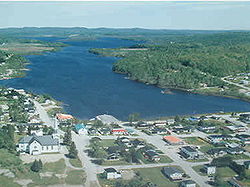 Sainte-Anne-du-Lac and Lake Tapani | |
 Coat of arms | |
 Location within Antoine-Labelle RCM. | |
 Sainte-Anne-du-Lac Location in central Quebec | |
| Coordinates: 46°53′N 75°20′W / 46.883°N 75.333°WCoordinates: 46°53′N 75°20′W / 46.883°N 75.333°W[1] | |
| Country | Canada |
| Province | Quebec |
| Region | Laurentides |
| RCM | Antoine-Labelle |
| Settled | 1910s |
| Constituted | December 30, 1976 |
| Government | |
| • Mayor | Aimé Lachapelle |
| • Federal riding | Laurentides—Labelle |
| • Prov. riding | Labelle |
| Area | |
| • Total | 345.72 km2 (133.48 sq mi) |
| • Land | 322.59 km2 (124.55 sq mi) |
| • Water | 12.11 km2 (4.68 sq mi) |
| Population (2016)[3] | |
| • Total | 575 |
| • Density | 1.8/km2 (5/sq mi) |
| • Pop 2011-2016 | |
| • Dwellings | 364 |
| Time zone | UTC−05:00 (EST) |
| • Summer (DST) | UTC−04:00 (EDT) |
| Postal code(s) | J0W 1V0 |
| Area code(s) | 819 |
| Highways | |
| Website | www.municipalite.sainte -anne-du-lac.qc.ca |

Sainte-Anne-du-Lac is a municipality and village in the Laurentides region of Quebec, Canada, part of the Antoine-Labelle Regional County Municipality.
Sainte-Anne-du-Lac is the northernmost place in the Laurentides region, about 46 km (29 mi) from Mont-Laurier. The village itself is located at the northern terminus of Quebec Route 309, on the south shore of Lake Tapani.
Demographics[]
| Year | Pop. | ±% |
|---|---|---|
| 1991 | 637 | — |
| 1996 | 623 | −2.2% |
| 2001 | 570 | −8.5% |
| 2006 | 613 | +7.5% |
| 2011 | 619 | +1.0% |
| 2016 | 575 | −7.1% |
| 1991, 1996.[4] 2001, 2006.[5] 2011, 2016[3] | ||
Private dwellings occupied by usual residents: 285 (total dwellings: 364)
Mother tongue:
- French as first language: 95.65%
- English as first language: 2.61%
- English and French as first language: 0.87%
- Other as first language: 0.87%
See also[]
| Wikimedia Commons has media related to Sainte-Anne-du-Lac, Laurentides, Quebec. |
References[]
- ^ Reference number 77617 of the Commission de toponymie du Québec (in French)
- ^ Jump up to: a b Geographic code 79115 in the official Répertoire des municipalités (in French)
- ^ Jump up to: a b c "Census Profile, 2016 Census Sainte-Anne-du-Lac, Municipalité [Census subdivision], Quebec and Antoine-Labelle, Municipalité régionale de comté [Census division], Quebec". Statistics Canada. Retrieved 2020-01-27.
- ^ Population and Dwelling Counts, for Census Agglomerations in Alphabetical Order, 1991 and 1996 Censuses – 100% Data
- ^ 2006 Community Profiles – Yellowknife
| show Adjacent Municipal Subdivisions |
|---|
| hide | |
|---|---|
| Cities/towns | |
| Municipalities |
|
| Villages | |
| Unorganized territories | |
| |
Categories:
- Designated places in Quebec
- Incorporated places in Laurentides
- Municipalities in Quebec