Sardis City, Alabama
Sardis City, Alabama | |
|---|---|
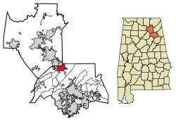 Location of Sardis City in Etowah County and Marshall County, Alabama. | |
| Coordinates: 34°10′26″N 86°7′17″W / 34.17389°N 86.12139°W | |
| Country | United States |
| State | Alabama |
| Counties | Etowah, Marshall |
| Area | |
| • Total | 7.88 sq mi (20.41 km2) |
| • Land | 7.86 sq mi (20.37 km2) |
| • Water | 0.02 sq mi (0.04 km2) |
| Elevation | 1,083 ft (330 m) |
| Population (2010) | |
| • Total | 1,704 |
| • Estimate (2019)[1] | 1,775 |
| • Density | 225.71/sq mi (87.15/km2) |
| Time zone | UTC-6 (Central (CST)) |
| • Summer (DST) | UTC-5 (CDT) |
| ZIP code | 35956 |
| Area code(s) | 256 |
| FIPS code | 01-68280 |
| GNIS feature ID | 0126416 |

Sardis City is a town in Etowah and Marshall counties in the U.S. state of Alabama. It is part of the Gadsden Metropolitan Statistical Area. It originally incorporated in May 1963 under the name of Sardis.[3] It later became Sardis City in the 1980s. At the 2010 census the population was 1,704.[4]
Geography[]
Sardis City is located at 34°10′26″N 86°7′17″W / 34.17389°N 86.12139°W (34.173967, -86.121319).[5]
According to the U.S. Census Bureau, the town has a total area of 7.9 square miles (20.4 km2), of which 7.8 square miles (20.3 km2) is land and 0.015 square miles (0.04 km2), or 0.20%, is water.[6]
Demographics[]
| Historical population | |||
|---|---|---|---|
| Census | Pop. | %± | |
| 1970 | 368 | — | |
| 1980 | 883 | 139.9% | |
| 1990 | 1,301 | 47.3% | |
| 2000 | 1,438 | 10.5% | |
| 2010 | 1,704 | 18.5% | |
| 2019 (est.) | 1,775 | [1] | 4.2% |
| U.S. Decennial Census[7] 2013 Estimate[8] | |||
At the 2000 census there were 1,438 people, 572 households, and 458 families living in the town. The population density was 195.1 people per square mile (75.3/km2). There were 597 housing units at an average density of 81.0 per square mile (31.3/km2). The racial makeup of the town was 99.10% White, 0.14% Black or African American, 0.07% Native American, 0.14% Pacific Islander, and 0.56% from two or more races. 0.63% of the population were Hispanic or Latino of any race.[9] Of the 572 households 32.2% had children under the age of 18 living with them, 68.7% were married couples living together, 8.4% had a female householder with no husband present, and 19.9% were non-families. 18.5% of households were one person and 9.6% were one person aged 65 or older. The average household size was 2.51 and the average family size was 2.82.
The age distribution was 22.2% under the age of 18, 9.3% from 18 to 24, 28.4% from 25 to 44, 26.1% from 45 to 64, and 14.0% 65 or older. The median age was 38 years. For every 100 females, there were 100.0 males. For every 100 females age 18 and over, there were 94.6 males.
The median household income was $36,000 and the median family income was $44,063. Males had a median income of $31,875 versus $21,711 for females. The per capita income for the town was $18,411. About 7.4% of families and 10.0% of the population were below the poverty line, including 11.9% of those under age 18 and 10.7% of those age 65 or over.
2010 census[]
At the 2010 census there were 1,704 people, 657 households, and 509 families living in the town. The population density was 220 people per square mile (84/km2). There were 703 housing units at an average density of 89.0 per square mile (34.5/km2). The racial makeup of the town was 98.2% White, 0.4% Black or African American, 0.1% Native American, 0.0% Pacific Islander, and 0.6% from two or more races. 0.7% of the population were Hispanic or Latino of any race.[10] Of the 657 households 31.2% had children under the age of 18 living with them, 63.0% were married couples living together, 10.2% had a female householder with no husband present, and 22.5% were non-families. 18.5% of households were one person and 10.5% were one person aged 65 or older. The average household size was 2.59 and the average family size was 2.97.
The age distribution was 24.4% under the age of 18, 6.8% from 18 to 24, 24.6% from 25 to 44, 28.1% from 45 to 64, and 16.1% 65 or older. The median age was 40.9 years. For every 100 females, there were 92.5 males. For every 100 females age 18 and over, there were 93.3 males.
The median household income was $45,714 and the median family income was $59,352. Males had a median income of $44,091 versus $28,333 for females. The per capita income for the town was $22,767. About 6.2% of families and 11.4% of the population were below the poverty line, including 8.9% of those under age 18 and 33.5% of those age 65 or over.
References[]
- ^ Jump up to: a b "Population and Housing Unit Estimates". United States Census Bureau. May 24, 2020. Retrieved May 27, 2020.
- ^ "2019 U.S. Gazetteer Files". United States Census Bureau. Retrieved June 29, 2020.
- ^ http://www.encyclopediaofalabama.org/article/h-3349
- ^ "Profile of General Population and Housing Characteristics: 2010 Demographic Profile Data (DP-1): Sardis City town, Alabama". United States Census Bureau. Retrieved June 5, 2012.
- ^ "US Gazetteer files: 2010, 2000, and 1990". United States Census Bureau. 2011-02-12. Retrieved 2011-04-23.
- ^ "Geographic Identifiers: 2010 Demographic Profile Data (G001): Sardis City town, Alabama". United States Census Bureau. Retrieved June 5, 2012.
- ^ "U.S. Decennial Census". Census.gov. Retrieved June 6, 2013.
- ^ "Annual Estimates of the Resident Population: April 1, 2010 to July 1, 2013". Retrieved June 3, 2014.
- ^ "U.S. Census website". United States Census Bureau. Retrieved 2008-01-31.
- ^ "U.S. Census website". United States Census Bureau. Retrieved 2015-07-23.
External links[]
Coordinates: 34°10′26″N 86°07′17″W / 34.173967°N 86.121319°W
| show Municipalities and communities of Etowah County, Alabama, United States |
|---|

| show Municipalities and communities of Marshall County, Alabama, United States |
|---|

| show Authority control |
|---|
- Towns in Etowah County, Alabama
- Towns in Marshall County, Alabama
- Towns in Alabama