Seč (Chrudim District)
Seč | |
|---|---|
Town | |
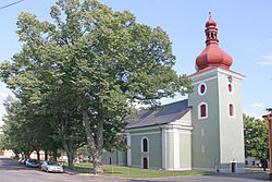 Church of Saint Lawrence | |
 Flag  Coat of arms | |
 Seč Location in the Czech Republic | |
| Coordinates: 49°50′55″N 15°39′25″E / 49.84861°N 15.65694°ECoordinates: 49°50′55″N 15°39′25″E / 49.84861°N 15.65694°E | |
| Country | |
| Region | Pardubice |
| District | Chrudim |
| First mentioned | 1318 |
| Government | |
| • Mayor | Marcel Vojtěch |
| Area | |
| • Total | 36.67 km2 (14.16 sq mi) |
| Elevation | 532 m (1,745 ft) |
| Population (2020-01-01[1]) | |
| • Total | 1,737 |
| • Density | 47/km2 (120/sq mi) |
| Time zone | UTC+1 (CET) |
| • Summer (DST) | UTC+2 (CEST) |
| Postal code | 538 05, 538 07 |
| Website | www |

Seč (German: Setsch) is a town in the Pardubice Region of the Czech Republic. It has about 1,700 inhabitants.
Administrative parts[]
Villages Hoješín, Javorka, Kraskov, Počátky, Proseč, Prosíčka, Přemilov, Ústupky and Žďárec u Seče are administrative parts of Seč.
Geography[]
Seč Dam is built next to the town.
Notable people[]
- Vincenc Strouhal (1850–1922), physicist
Twin towns – sister cities[]
 Radzovce, Slovakia
References[]
- ^ "Population of Municipalities – 1 January 2020". Czech Statistical Office. 2020-04-30.
- ^ "Oheb – Zpravodaj města Seč 2/2019". mestosec.cz (in Czech). Město Seč. June 2019. p. 5. Retrieved 2020-08-25.
External links[]
| Wikimedia Commons has media related to Seč (Chrudim District). |
| show Authority control |
|---|
This Chrudim District location article is a stub. You can help Wikipedia by . |
Categories:
- Cities and towns in the Czech Republic
- Populated places in Chrudim District
- Pardubice Region geography stubs