Slatiňany
Slatiňany | |
|---|---|
Town | |
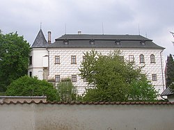 Slatiňany Castle – eastern wing | |
 Flag  Coat of arms | |
| Etymology: moor-dwellers | |
 Slatiňany Location in the Czech Republic | |
| Coordinates: 49°55′5″N 15°48′57″E / 49.91806°N 15.81583°ECoordinates: 49°55′5″N 15°48′57″E / 49.91806°N 15.81583°E | |
| Country | |
| Region | Pardubice |
| District | Chrudim |
| First mentioned | 1294 |
| Government | |
| • Mayor | Ivan Jeník |
| Area | |
| • Total | 15.60 km2 (6.02 sq mi) |
| Elevation | 268 m (879 ft) |
| Population (2020-01-01[1]) | |
| • Total | 4,217 |
| • Density | 270/km2 (700/sq mi) |
| Time zone | UTC+1 (CET) |
| • Summer (DST) | UTC+2 (CEST) |
| Postal code | 538 21 |
| Website | www |

Slatiňany (Czech pronunciation: [ˈslacɪɲanɪ]) is a town in the Pardubice Region of the Czech Republic. It has around 4,200 inhabitants.
Administrative parts[]
Villages Kochánovice, Kunčí, Škrovád and Trpišov are administrative parts of Slatiňany.
Notable people[]
- Helena Vondráčková (born 1947), singer; raised here
Twin towns – sister cities[]
Slatiňany is twinned with:[2][3]
References[]
- ^ "Population of Municipalities – 1 January 2020". Czech Statistical Office. 2020-04-30.
- ^ "Odkazy". slatinany.cz (in Czech). Město Slatiňany. Retrieved 2021-03-18.
- ^ "Ozvěny Slatiňan srpen 2014" (PDF). slatinany.cz (in Czech). Město Slatiňany. August 2014. p. 3. Retrieved 2021-03-18.
External links[]
| Wikimedia Commons has media related to Slatiňany. |
| show Authority control |
|---|
This Chrudim District location article is a stub. You can help Wikipedia by . |
Categories:
- Populated places in Chrudim District
- Cities and towns in the Czech Republic
- Pardubice Region geography stubs