Selura
From Wikipedia, the free encyclopedia
| Selura | |
|---|---|
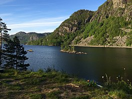 View of the lake | |
 Selura  Selura | |
| Location | Flekkefjord, Agder |
| Coordinates |  58°18′30″N 06°42′12″E / 58.30833°N 6.70333°E / 58.30833; 6.70333 58°18′30″N 06°42′12″E / 58.30833°N 6.70333°E / 58.30833; 6.70333 |
| Primary outflows | Grisefjorden |
| Basin countries | Norway |
| Max. length | 5.6 kilometres (3.5 mi) |
| Max. width | 3 kilometres (1.9 mi) |
| Surface area | 5.7 km2 (2.2 sq mi) |
| Shore length1 | 31.48 kilometres (19.56 mi) |
| Surface elevation | 32 metres (105 ft) |
| References | NVE |
| 1 Shore length is not a well-defined measure. | |
Selura is a lake in the municipality of Flekkefjord in Agder county, Norway.[1]
Location[]
The 5.7-square-kilometre (2.2 sq mi) lake is located at an elevation of 32 metres (105 ft) above sea level and it is about 130 metres (430 ft) at its deepest. The lake lies immediately northeast of the town of Flekkefjord
Selurafossen, the waterfall at the outflow of Lake Selura, historically provided a source of power for some industries, including a barrel factory and tannery in Flekkefjord.
See also[]
- List of lakes in Norway
References[]
- ^ "Selura, Flekkefjord (Vest-Agder)" (in Norwegian). yr.no. Retrieved 2016-09-07.
Retrieved from ""
Categories:
- Flekkefjord
- Lakes of Agder
Hidden categories:
- CS1 Norwegian-language sources (no)
- Articles using infobox body of water without alt
- Articles using infobox body of water without pushpin map alt
- Articles using infobox body of water without image bathymetry