Sheldon, South Carolina
Coordinates: 32°36′07″N 80°47′35″W / 32.602°N 80.793°W

Sheldon | |
|---|---|
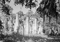 Old Sheldon Church Ruins | |
| Country | United States |
| State | South Carolina |
| County | Beaufort |
| Elevation | 17 ft (5 m) |
| Population (United States Census 2010) | |
| • Total | 5,201 |
| ZIP codes | 29941 |
| Area code(s) | 843, 854 |
Sheldon is an unincorporated community in Beaufort County, South Carolina, United States, at latitude 32.602 and longitude –80.793. Sheldon is located approximately halfway between Beaufort and Yemassee and just east of Interstate 95 in the heart of the Lowcountry region. U.S. Routes 17 and 21 run through the center of the community in a wrong-way concurrency.
A rural area in character, Sheldon was primarily a common gathering area for various plantation owners and slaves prior to the Civil War. It is renowned for the Old Sheldon Church Ruins. Several hunt clubs and gated communities are located in the area.
The Pocosobo Town was listed on the National Register of Historic Places in 1994.[1]
References[]
Municipalities and communities of Beaufort County, South Carolina, United States | ||
|---|---|---|
| Cities |  | |
| Towns | ||
| CDPs | ||
| Other communities | ||
| Footnotes | ‡This populated place also has portions in an adjacent county or counties | |
| ||
The Lowcountry of South Carolina | ||
|---|---|---|
| Counties | 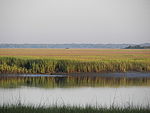 | |
| Major communities | ||
| Sea islands | ||
| History & culture | ||
| Military installations |
| |
| Natural areas | ||
| Other articles |
| |
This South Carolina state location article is a stub. You can help Wikipedia by . |
- Unincorporated communities in South Carolina
- Unincorporated communities in Beaufort County, South Carolina
- South Carolina geography stubs