Shire of Oxley
| Shire of Oxley Victoria | |||||||||||||||
|---|---|---|---|---|---|---|---|---|---|---|---|---|---|---|---|
 Location in Victoria | |||||||||||||||
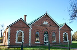 Oxley Shire Hall | |||||||||||||||
| Population | 5,310 (1992)[1] | ||||||||||||||
| • Density | 1.9038/km2 (4.931/sq mi) | ||||||||||||||
| Established | 1862 | ||||||||||||||
| Area | 2,789.2 km2 (1,076.9 sq mi) | ||||||||||||||
| Council seat | Wangaratta | ||||||||||||||
| County | Delatite | ||||||||||||||
| |||||||||||||||
The Shire of Oxley was a local government area in Victoria, Australia, immediately to the south of the city of Wangaratta, which housed the shire's council chambers. Oxley covered an area of 2,789.2 square kilometres (1,076.92 sq mi), and existed from 1862 until 1994.
History[]
The Oxley Road District was incorporated on 21 November 1862, and became a shire on 12 December 1865, after changes to local government legislation. Subsequently, it was divided into Eastern, Central and Western Ridings, each of which elected three councillors.[2]
On 18 November 1994, the Shire of Oxley was abolished, and, along with the City of Wangaratta, the Shire of Wangaratta, and various surrounding districts, was merged into the newly created Rural City of Wangaratta.[3]
The councillors of the Oxley Shire commissioned Graham Jones to prepare a history of the shire which was published in 1995 as Memories of Oxley.
Towns[]
|
|
Population[]
| Year | Population |
|---|---|
| 1954 | 4,393 |
| 1958 | 4,570* |
| 1961 | 5,229 |
| 1966 | 5,356 |
| 1971 | 5,595 |
| 1976 | 4,974 |
| 1981 | 4,860 |
| 1986 | 4,916 |
| 1991 | 5,047 |
* Estimate in the 1958 Victorian Year Book.
References[]
- ^ Australian Bureau of Statistics, Victoria Office (1994). Victorian Year Book. p. 53. ISSN 0067-1223.
- ^ Victorian Municipal Directory. Brunswick: Arnall & Jackson. 1992. pp. 803–804. Accessed at State Library of Victoria, La Trobe Reading Room.
- ^ Australian Bureau of Statistics (1 August 1995). Victorian local government amalgamations 1994-1995: Changes to the Australian Standard Geographical Classification (PDF). Commonwealth of Australia. p. 9. ISBN 0-642-23117-6. Retrieved 5 January 2008.
| show Authority control |
|---|
Coordinates: 36°27′S 146°19′E / 36.450°S 146.317°E

This article about a location in Victoria, Australia is a stub. You can help Wikipedia by . |
- Former local government areas of Victoria (Australia)
- 1862 establishments in Australia
- Victoria (Australia) geography stubs