Southfield, Michigan
Southfield, Michigan | |
|---|---|
City | |
| City of Southfield | |
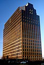
Left to right from top: Southfield Town Center, American Center, Southfield Public Library, One Towne Square, and Lawrence Technological University. | |
 Flag  Seal | |
| Motto(s): The Center of it All | |
 Location within Oakland County | |
 Southfield Location within the state of Michigan | |
| Coordinates: 42°28′47″N 83°14′42″W / 42.47972°N 83.24500°WCoordinates: 42°28′47″N 83°14′42″W / 42.47972°N 83.24500°W | |
| Country | |
| State | |
| County | |
| Organized | 1830 (as Southfield Township) |
| Incorporated | 1958 |
| Government | |
| • Type | Mayor–council |
| • Mayor | Kenson J. Siver |
| • Manager | Frederick E. Zorn |
| Area | |
| • City | 26.26 sq mi (68.01 km2) |
| • Land | 26.25 sq mi (68.00 km2) |
| • Water | 0.01 sq mi (0.01 km2) |
| Elevation | 682 ft (208 m) |
| Population | |
| • City | 71,758 |
| • Estimate (2019)[5] | 72,689 |
| • Density | 2,768.58/sq mi (1,068.96/km2) |
| • Metro | 4,296,250 (Metro Detroit) |
| Time zone | UTC-5 (EST) |
| • Summer (DST) | UTC-4 (EDT) |
| ZIP code(s) | 48033, 48034, 48037, 48075, 48076, 48086 |
| Area code(s) | 248 and 947 |
| FIPS code | 26-74900[3] |
| GNIS feature ID | 0638439[4] |
| Website | Official website |


Southfield is a city in Oakland County in the U.S. state of Michigan. As of the 2010 census, the city had a population of 71,739.[6]
As a northern suburb of Detroit, Southfield shares part of its southern border with Detroit. The city was originally part of Southfield Township before incorporating in 1958. The autonomous city of Lathrup Village is an enclave within Southfield. The city is home to the Southfield Town Center complex, which includes five interconnected office buildings. The tallest of these, 3000 Town Center, is 402 feet (122.5 m) tall; it is the state's second-tallest building outside Detroit (after the River House Condominiums in Grand Rapids) and the state's 16th-tallest building overall.
History[]
Southfield was surveyed in 1817 according to the plan by Michigan territorial governor Lewis Cass.[7] The first settlers came from nearby Birmingham and Royal Oak, Michigan, as well as New York and Vermont. The area that became Southfield was settled by John Daniels in 1823. Among the founders were the Heth, Stephens, Harmon, McClelland and Thompson families.
Town 1 north, 10 east was first organized as Ossewa Township on July 12, 1830, but the name was changed to Southfield Township 17 days later .[7] The township took its name from its location in the "south fields" of Bloomfield Township. A US post office was established in 1833 and the first town hall built in 1873.

The Southfield Fire Department was formed on April 6, 1942, and the Southfield Police Department in 1953.[citation needed] In the 1950s, cities and villages began to incorporate within the township, including Lathrup Village in 1950, and Beverly Hills in 1957. Most of what was left of the township was formally incorporated as a city on April 28, 1958, to protect it from annexation attempts by Detroit; whites who had migrated to the suburbs did not want to be associated with Detroit's expanding black community.[8]
City Hall was built in 1964 as part of the new Civic Center complex, which also became home to Southfield's police headquarters. The Civic Center was expanded in 1971 to include a sports arena with swimming pool. Evergreen Hills Golf Course was added in 1972, and in 1978, a new public safety building, the Southfield Pavilion, and a new court building were added. In 2003, an expanded and redesigned Southfield Public Library opened to the public on the Civic Center grounds, featuring state-of-the-art facilities. Outside the Civic Center complex, Southfield has municipal parks and recreation facilities, largely developed in the 1970s, including Beech Woods Recreation Center and John Grace Community Center.
Duns Scotus College is now the home of Word of Faith Christian Center.
Economy[]

Southfield is a commercial and business center for the metropolitan Detroit area, with 27,000,000 square feet (2,508,400 m2) of office space, second in the Detroit metro area to Detroit's central business district of 33,251,000 square feet (3,089,000 square meters). Several internationally recognized corporations have major offices and headquarters in Southfield, including Veoneer, , Denso, , Federal-Mogul, Lear, R.L. Polk & Co., International Automotive Components, and Guardian Alarm. More than 100 Fortune 500 companies have offices in Southfield.
Sumitomo Corporation operates the Detroit Office in Suite 1450 at 27777 Franklin Road. Industries supported by the office include automotive, rolled steel, and tubular products.[9]
On October 28, 2014, Fifth Third Bank announced plans to move its Michigan regional headquarters from Southfield to downtown Detroit in what will be named the Fifth Third Bank Building at One Woodward.[10] The office had 150 employees.[11]
Northland Center, one of the nation's first shopping malls, opened in Southfield in 1954 and closed in 2015. Southfield is home to over 780 acres (3.2 km2) of parkland and a nationally recognized public school district.[who?]
Southfield City Centre[]
Prominent in Southfield is Southfield City Centre, a mixed-use area consisting of a major business center, private university, and residential neighborhoods, near the intersection of Interstate 696 (I-696, Walter P. Reuther Freeway) and the M-10 (Lodge Freeway).
Southfield City Centre was created in 1992 as a special assessment district, and was originally planned to improve pedestrian amenities and facilitate economic development.
Diplomatic missions[]
The Consulate of Macedonia in Detroit is in the Southfield Town Center,[12] and the Consulate of Iraq in Detroit is in Southfield.[13]
Conventions[]
Penguicon has been held in Southfield regularly since 2014.
Geography[]

According to the United States Census Bureau, the city has an area of 26.28 square miles (68.06 km2), of which 26.27 square miles (68.04 km2) is land and 0.01 square miles (0.03 km2) (0.04%) is water.[14]
The main branch of the River Rouge runs through Southfield. The city is bounded to the south by Eight Mile Road, its western border is Inkster Road, and to the east it is bounded by Greenfield Road. Southfield's northern border does not follow a single road, but lies approximately along Thirteen Mile Road. The city is bordered by Detroit and Redford Township to the south, Farmington Hills to the west, Franklin, Bingham Farms, and Beverly Hills to the north and Royal Oak, Berkley and Oak Park to the east. The separate city of Lathrup Village sits as an enclave in the eastern part of the city, completely surrounded by Southfield.
Demographics[]


| Historical population | |||
|---|---|---|---|
| Census | Pop. | %± | |
| 1960 | 31,531 | — | |
| 1970 | 69,298 | 119.8% | |
| 1980 | 75,608 | 9.1% | |
| 1990 | 75,745 | 0.2% | |
| 2000 | 78,322 | 3.4% | |
| 2010 | 71,758 | −8.4% | |
| 2019 (est.) | 72,689 | [5] | 1.3% |
| U.S. Decennial Census[15] | |||
2010 census[]
As of the census[2] of 2010, there were 71,739 people, 31,778 households, and 18,178 families residing in the city. The population density was 2,730.8 inhabitants per square mile (1,054.4/km2). There were 35,986 housing units at an average density of 1,369.9 per square mile (528.9/km2). The racial makeup of the city was 70.3% African American, 24.9% White, 0.2% Native American, 1.7% Asian, 0.4% from other races, and 2.4% from two or more races. Hispanic or Latino of any race were 1.3% of the population.
There were 31,778 households, of which 26.7% had children under the age of 18 living with them, 33.5% were married couples living together, 19.4% had a female householder with no husband present, 4.4% had a male householder with no wife present, and 42.8% were non-families. 37.9% of all households were made up of individuals, and 13.7% had someone living alone who was 65 years of age or older. The average household size was 2.22 and the average family size was 2.96.
The median age in the city was 42. 20.5% of residents were under the age of 18; 8.5% were between the ages of 18 and 24; 24.7% were from 25 to 44; 29.2% were from 45 to 64; and 16.9% were 65 years of age or older. The gender makeup of the city was 44.7% male and 55.3% female.
2000 census[]
As of the census[3] of 2000, there were 78,296 people, 33,987 households, and 19,780 families residing in the city. The population density was 2,984.6 per square mile (1,152.5/km2). There were 35,698 housing units at an average density of 1,360.8 per square mile (525.5/km2). The racial makeup of the city was 54.22% African American, 38.83% White, 3.09% Asian, 0.20% Native American, 0.03% Pacific Islander, 0.64% from other races, and 2.99% from two or more races. 1.19% of the population were Hispanic or Latino of any race.
Of the city's 33,987 households, 25.3% had children under the age of 18 living with them, 40.2% were married couples living together, 14.3% had a female householder with no husband present, and 41.8% were non-families. 36.2% of all households were made up of individuals, and 11.9% had someone living alone who was 65 years of age or older. The average household size was 2.27 and the average family size was 3.01.
The age distribution in the city's population was spread out, with 21.6% under the age of 18, 7.9% from 18 to 24, 30.6% from 25 to 44, 24.8% from 45 to 64, and 15.2% who were 65 years of age or older. The median age was 38. For every 100 females there were 84.9 males. For every 100 females age 18 and over, there were 80.9 males.
The median income for a household in the city was $51,802, and the median income for a family was $64,543. Males had a median income of $48,341 versus $37,949 for females. The per capita income for the city was $28,096. About 5.8% of families and 7.4% of the population were below the poverty line, including 8.2% of those under age 18 and 10.2% of those age 65 or over.
Socioeconomic status[]
The most common occupations for people in Southfield are a mix of both white- and blue-collar jobs. Overall, Southfield is a city of sales and office workers, professionals and managers. A relatively large number of people living in Southfield work in office and administrative support (16.00%), sales jobs (10.93%), and management occupations (9.72%). Southfield's populace is very well-educated relative to most cities and towns in the nation. Whereas 21.84% of the average community's adult population holds a 4-year degree or higher, 38.73% of Southfield's adults have a bachelor's degree or advanced degree. Southfield's per capita income in 2010 was $28,995.[16]
Ethnic groups[]
African Americans[]
In 2002 Southfield had 42,259 black people, the second-largest black population in Metro Detroit and third-largest in Michigan.[17]
As of 2011, many African Americans from Detroit were moving into Southfield and other suburbs of Oakland and Macomb counties. Tensions have occurred between existing middle-class blacks in Southfield and newcomers from Wayne County.[18]
Chaldeans[]
As of 2001 many Chaldeans live in Southfield; they are mostly Assyrian Christians. The Chaldean Federation of America, an umbrella organization for most regional Chaldean groups, is in Southfield. As of that year, the largest Chaldean church, by number of congregants, was based here. The city also had the area's sole Chaldean retirement home.[19]
Government[]

Southfield uaes the council-manager form of government, and thus is governed by a City Council consisting of seven council members. The city council appoints a City Administrator, who manages the day-to-day operations of the city. The popularly elected mayor, who does not vote on council actions, has the right to veto council actions and appoints the city's planner, assessor, attorney, and members of various commissions. The city's clerk and treasurer are also popularly elected officials. All these officials hold nonpartisan positions.
- City officials
- Mayor (term expires November 2021)
- City Council
- Council President (term expires November 2019)
- Council President Pro Tem (term expires November 2021)
- Council Member (term expires November 2021)
- Council Member (term expires November 2019)
- Council Member (term expires November 2019)
- Council Member (term expires November 2019)
- Council Member (term expires November 2021)
- Other elected officials
- City Clerk Sherika L. Hawkins (term expires November 2021)
- City Treasurer (term expires November 2021)
- State officials
- Governor Gretchen Whitmer (D)
- State Senator Jeremy Moss (D) – 14th State Senate District
- State Representative (D) – 35th State House District
- Federal officials
- Senator Gary C. Peters (D)
- Senator Debbie Stabenow (D)
- Representative Brenda Lawrence (D) – 14th Congressional District
Education[]

Southfield Public Schools operates area public schools. Southfield Senior High School for the Arts and Technology (commonly known as Southfield A&T) is the district's sole high school. There were originally two high schools in the district, Southfield and Southfield-Lathrup, but they were consolidated after the 2015–16 school year.[20] Students living in parts of Northern Southfield attend schools in the Birmingham City School District, while students living in the southeast corner of Southfield attend schools in the Oak Park School District.[21] Southfield A&T also competes in the Oakland Activities Association in the Red Division for high school sports, and has membership in the MHSAA.[22]
AGBU Alex and Marie Manoogian School is an Armenian charter in Southfield.
Farber Hebrew Day School – Yeshivat Akiva is a private Jewish school in Southfield.
Southfield Christian School is a private school in Southfield.
Southfield Public Library operates public libraries in the city.Providence Medical Center offers residency training in various fields of medicine.
Colleges and universities[]
Southfield is home to eight colleges, including Lawrence Technological University, , Everest Institute and Oakland Community College. The Specs Howard School of Media Arts is in Southfield.
Media[]
Southfield is the broadcast media center for the Detroit area, with studios and broadcast facilities for several television stations, including WXYZ-TV, WJBK, WKBD-TV, WMYD-TV, WWJ-TV, and City Cable 15. Metro Detroit's regional sports network Bally Sports Detroit is in Southfield on 11 Mile and Evergreen roads. A transmitter for WDIV-TV is in the city; it is the only television station based in downtown Detroit.
The city is home to Audacy’s Detroit studios. Southfield is also served by WSHJ 88.3 FM, a student-run radio station sponsored by Southfield Public Schools.
In 1970, radio pioneer and entertainer Specs Howard founded the Specs Howard School of Media Arts in Southfield.[23][24]
In addition to The Detroit News and Free Press, Detroit's two metropolitan daily newspapers, Southfield is served by the , a suburban paper that reports on local and community events, which is published twice a week, on Sunday and Thursday.[citation needed] The headquarters of The Detroit Jewish News is in Southfield.[25] The is also headquartered in Southfield.[26]
Transportation[]

Suburban Mobility Authority for Regional Transportation (SMART) operates local and regional bus transit.
The major thoroughfares in the city include the John C. Lodge Freeway (M-10), which is among the first urban to suburban highways constructed in the United States. The city also contains I-696, Southfield Freeway (M-39), and US 24 (Telegraph Road). The city has several freeway interchanges connecting local roads to the freeways. Most prominently, "The Lodge" freeway connects downtown Detroit to "The Mixing Bowl," the sprawling interchange of I-696, US 24, M-10, Lahser Road, and Franklin Road, all of which are in Southfield.
Most major streets adhere to a north–south/east–west orientation, forming a grid of major streets spaced one mile (1.6 km) apart from each other. The major east–west streets are 8 Mile Road (which forms the southern boundary of the city), 9 Mile Road (which is split by the Southfield Freeway), 10 Mile Road, 11 Mile Road (which is split by the Lodge), and 12 Mile Road. Major north–south streets are Telegraph Road, Lahser Road, Evergreen Road, Southfield Road (the northern extension of the Southfield Freeway) and Greenfield Road (which forms the eastern boundary of the city).
Religion[]
The Roman Catholic Archdiocese of Detroit formerly operated the Church of St. Bede. By 2013 there was a debate on how the property should be rezoned, and therefore reused.[27]
Parks and recreation[]
This section needs expansion. You can help by . (November 2013) |
The Southfield Parks and Recreation Department is responsible for 775 acres of parks, nature preserves and open space and historic properties at 33 sites within the city. There are numerous ball fields, tennis and handball courts, picnic areas and shelters. There are soccer fields, play lots and sand volleyball courts throughout the city.[28][29]
- Bauervic Woods Park
- Bedford Woods Park
- Beech Woods Park
- Brace Park
- Burgh Historical Park
- Carpenter Lake Nature Preserve
- Civic Center Park
- Freeway Park
- Inglenook Park
- John Grace Park & Community Center
- John R. Miller Park
- Lahser Woods Park
- Lincoln Woods
- Mary Thompson House & Farm[30]
- Pebble Creek Park
- Simms Park
- Stratford Woods Commons
- Valley Woods Nature Preserve
Notable people[]
- Jay Adelson, entrepreneur
- Ingrid Andress, country singer-songwriter (born in Southfield, Michigan)
- Johnathon Banks, boxer
- Jeff Blashill, professional ice hockey head coach
- Selma Blair, actress
- Harry J. Brooks (1902-1927), test pilot
- Jimmy Carson, professional hockey player
- Mike Chappell, professional basketball player
- Elijah Connor, singer
- Billy Davis, musician currently living in Southfield
- Erin Dilly, actress raised in Southfield
- Glenn Earl, professional football player
- Geoffrey Fieger, attorney for Jack Kevorkian based in Southfield
- Susie Garrett (1929-2002), actress
- Chris Getz, professional baseball player
- Nicole Gibbons, TV personality
- Dan Gilbert, businessman raised in Southfield
- Jon Glaser, actor raised in Southfield
- GRiZ, American DJ and electronic producer
- Yasmine Hanani, actress
- Carla Harvey, musician
- Thomas Hearns, retired boxer living in Southfield
- I Prevail, metal band from Southfield
- Ben Kelso, professional basketball player
- Keegan-Michael Key, actor
- Byron Krieger (1920-2015), Olympic fencer
- Tony Leech, director, screenwriter, editor
- Eric Lefkofsky, businessman
- Raynetta Mañees, novelist, entertainer
- Devyn Marble (born 1992), basketball player for Maccabi Haifa of the Israeli Basketball Premier League
- Howard Markel, medical historian
- Roya Megnot (1962-2009), actress
- Jeremy Moss, politician
- Colette Nelson, body builder
- Chukwuma Okorafor, professional football player
- Lawrence Payton (1938-1997), musician
- Matt Pike, musician
- Steven Pitt (1959-2018), American forensic psychiatrist
- Mike Posner, singer-songwriter
- Bill Prady, television writer raised in Southfield
- Emily Samuelson, ice dancer
- Debbie Schlussel, film critic
- Jay Sebring (1933-1969), celebrity hair stylist and victim of the Manson Family
- Jason Stollsteimer, musician
- Jennifer Laura Thompson, actress
- Malaya Watson, singer
- Rick Worthy, actor
- Sheldon Yellen, entrepreneur
See also[]
- Architecture of metropolitan Detroit
- Lawrence Technological University
- Metro Detroit
- Tourism in metropolitan Detroit
- History of the African-Americans in Metro Detroit
- Specs Howard School of Media Arts
References[]
- ^ "2019 U.S. Gazetteer Files". United States Census Bureau. Retrieved July 25, 2020.
- ^ Jump up to: a b "U.S. Census website". United States Census Bureau. Retrieved November 25, 2012.
- ^ Jump up to: a b "U.S. Census website". United States Census Bureau. Retrieved January 31, 2008.
- ^ "Southfield". Geographic Names Information System. United States Geological Survey.
- ^ Jump up to: a b "Population and Housing Unit Estimates". United States Census Bureau. May 24, 2020. Retrieved May 27, 2020.
- ^ "Race, Hispanic or Latino, Age, and Housing Occupancy: 2010 Census Redistricting Data (Public Law 94-171) Summary File (QT-PL), Southfield city, Michigan". United States Census Bureau. Retrieved August 19, 2011.
- ^ Jump up to: a b "City of Southfield website, History of Southfield webpage". Archived from the original on April 2, 2016. Retrieved July 31, 2012.
- ^ Sugrue, T. (1996). The Origins of the Urban Crisis: Race and Inequality in Postwar Detroit. Princeton, NJ: Princeton University Press.
- ^ "Office Network Archived February 1, 2009, at the Wayback Machine." Sumitomo Corporation. Retrieved on January 26, 2009.
- ^ Pinho, Kirk (October 28, 2014). "Fifth Third Bank to move 150 employees downtown as part of $85M investment in Detroit". Crain's Detroit Business. Retrieved October 28, 2014.
- ^ Gallagher, John. "Fifth Third Bank to move to downtown Detroit" (Archive). Detroit Free Press. October 27, 2014. Retrieved on November 27, 2015.
- ^ "Macedonia[permanent dead link]." Consular Corps of Detroit. Retrieved on January 26, 2009.
- ^ "CONSULAR SERVICES." Embassy of Iraq in Washington, DC. Retrieved on November 22, 2010.
- ^ "US Gazetteer files 2010". United States Census Bureau. Retrieved November 25, 2012.
- ^ "Census of Population and Housing". Census.gov. Retrieved June 4, 2015.
- ^ Williams, Corey. "'Neighborhood profile'.
- ^ Metzger, Kurt and Jason Booza. "African Americans in the United States, Michigan and Metropolitan Detroit Archived November 9, 2013, at WebCite." (Archive) Center for Urban Studies, Wayne State University. February 2002. Working Paper Series, No. 8. p. 8. Retrieved on November 9, 2013.
- ^ Dawsey, Darrell. "Housing crisis in metro Detroit creating black class tensions in Southfield." MLive.com. February 28, 2011. Retrieved on February 18, 2014.
- ^ Smith, Natalie Jill. "Ethnicity, Reciprocity, Reputation and Punishment: An Ethnoexperimental Study of Cooperation among the Chaldeans and Hmong of Detroit (Michigan)" (PhD dissertation). University of California, Los Angeles, 2001. p. 41. UMI Number: 3024065.
- ^ "[1]" . Retrieved on June 27, 2018.
- ^ "SCHOOL DISTRICT REFERENCE MAP (2010 CENSUS): Oakland County, MI" (Archive). U.S. Census Bureau. Retrieved on June 29, 2015.
- ^ "Oakland Activities Association Football". Retrieved July 31, 2012.
- ^ "Specs Howard School of Broadcast Arts Inc – School Description". Campus Explorer. August 27, 2009. Retrieved August 27, 2009.
- ^ Kaylee Hawkins (August 25, 2009). "Specs Howard honored with MAB Lifetime Achievement Award". Detroiter Online. Archived from the original on September 21, 2009. Retrieved August 27, 2009.
- ^ "Contact Us." (Archive) The Detroit Jewish News. Retrieved on December 2, 2013. "Detroit Jewish News 29200 Northwestern Hwy., Suite 110, Southfield, MI 48034"
- ^ "Contact." . Retrieved on April 14, 2014. "29850 Northwestern Hwy. Southfield, MI 48034"
- ^ Strachan, Jessica (February 6, 2013). "What happens next to St. Bede?". . . Retrieved May 2, 2020.
- ^ "Southfield welcomes culture." The Detroit News. September 8, 2004. Retrieved on Sunday November 10, 2013. ID: det19737754. "Brad Parks, 43, brought his family to the Japan Festival because he's[...]"
- ^ "City of Southfield - Parks & Recreation". www.cityofsouthfield.com.
- ^ "Mary Thompson Farmhouse". Southfield Public Library. June 21, 2010.
External links[]
| Wikimedia Commons has media related to Southfield, Michigan. |
| Wikivoyage has a travel guide for Southfield. |
| show Municipalities and communities of Oakland County, Michigan, United States |
|---|


| show |
|---|

| show Authority control |
|---|
- Southfield, Michigan
- Cities in Oakland County, Michigan
- Metro Detroit
- Populated places established in 1823
- 1823 establishments in Michigan Territory