Pleasant Ridge, Michigan
Pleasant Ridge, Michigan | |
|---|---|
| City of Pleasant Ridge | |
 | |
 Flag  Seal | |
 Location within Oakland County | |
 Pleasant Ridge Location within the state of Michigan | |
| Coordinates: 42°28′16″N 83°08′32″W / 42.47111°N 83.14222°WCoordinates: 42°28′16″N 83°08′32″W / 42.47111°N 83.14222°W | |
| Country | United States |
| State | Michigan |
| County | Oakland |
| Founded | 1913 |
| Incorporated | 1921 (village) 1927 (city) |
| Government | |
| • Type | City commission |
| • Mayor | Kurt Metzger |
| • Clerk | Amy Allison |
| Area | |
| • City | 0.56 sq mi (1.46 km2) |
| • Land | 0.56 sq mi (1.46 km2) |
| • Water | 0.00 sq mi (0.00 km2) |
| Elevation | 650 ft (195 m) |
| Population | |
| • City | 2,526 |
| • Estimate (2019)[3] | 2,425 |
| • Density | 4,307.28/sq mi (1,662.51/km2) |
| • Metro | 4,296,250 (Metro Detroit) |
| Time zone | UTC-5 (EST) |
| • Summer (DST) | UTC-4 (EDT) |
| ZIP code(s) | 48069 |
| Area code(s) | 248 |
| FIPS code | 26-64900[4] |
| GNIS feature ID | 0635117[5] |
| Website | Official website |

Pleasant Ridge is a city in Oakland County in the U.S. state of Michigan. The population was 2,526 at the 2010 census.[6] Located along the Woodward Corridor and Interstate 696, Pleasant Ridge is a northern suburb of Metro Detroit and is about 1.5 miles (2.4 km) north of the city of Detroit.
With a land area of 0.57 square miles (1.48 km2), Pleasant Ridge is the fifth-smallest city by land area in the state of Michigan after the cities of Sylvan Lake, Keego Harbor, Petersburg, and Clarkston.[7]
Geography[]
According to the United States Census Bureau, the city has a total area of 0.57 square miles (1.48 km2), all land.[8]
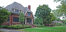
The portion of the city located west of Woodward Avenue (M-1) includes the Pleasant Ridge Historic District and its spacious residential homes, while an area of more modest homes is located east of Woodward.[9]
History[]
Pleasant Ridge began with the subdivision of the Mayday farm by Burt Taylor in 1913. It incorporated as a village in 1921 and as a city in 1927.[10] On December 1, 2009, the Pleasant Ridge City Council approved plans for the city's first bar. Pleasant Ridge had previously been a dry community.[11]
The city is named after the slight ridge that ran through the city.
One of Pleasant Ridge's most popular landmarks[citation needed] was Hedge's Wigwam, a Native American-themed cafeteria-style restaurant which was located at 10 Mile and Woodward from 1927 until 1967.[citation needed]
Pleasant Ridge was actively involved in resisting the construction of the middle segment of Interstate 696.[12]
Same-sex households[]
Pleasant Ridge is bordered on the south by the city of Ferndale, which is considered the center of the LGBT community in the Metro Detroit region.[13] The city of Pleasant Ridge is among the top cities in the nation with same-sex couple households, with at least 60 per 1,000 according to figures from the United States Census Bureau.[14] A study by the Williams Institute from the University of California, Los Angeles recorded 59.55 same-sex couples for every 1,000 households in the city of Pleasant Ridge, while the state as a whole ranked low with only 5.6 for every 1,000 households. However, the study did not record the number of gay people, only the number of same-sex households. The study listed Pleasant Ridge as having the highest same-sex household ratio in the state, ahead of Ferndale with 35.0 same-sex couples for every 1,000 households.[15]
These numbers rank Pleasant Ridge as having the seventh-highest same-sex household ratio in the nation.[16] Cities in the nation within a higher ratio include Provincetown, Massachusetts; Wilton Manors, Florida; Palm Springs, California; Rehoboth Beach, Delaware; Guerneville, California; and West Hollywood, California.[17]
Government[]
Pleasant Ridge is governed by a city commission consisting of a mayor and four city commissioners. The current mayor of Pleasant Ridge is Kurt Metzger. Current city commissioners are Amanda Wahl, Chris Budnik, Ann Perry and Bret Scott.
Demographics[]
| Historical population | |||
|---|---|---|---|
| Census | Pop. | %± | |
| 1920 | 472 | — | |
| 1930 | 2,885 | 511.2% | |
| 1940 | 3,391 | 17.5% | |
| 1950 | 3,594 | 6.0% | |
| 1960 | 3,807 | 5.9% | |
| 1970 | 3,989 | 4.8% | |
| 1980 | 3,217 | −19.4% | |
| 1990 | 2,775 | −13.7% | |
| 2000 | 2,594 | −6.5% | |
| 2010 | 2,526 | −2.6% | |
| 2019 (est.) | 2,425 | [3] | −4.0% |
| U.S. Decennial Census[18] | |||
2010 census[]
As of the census[2] of 2010, there were 2,526 people, 1,115 households, and 674 families living in the city. The population density was 4,431.6 inhabitants per square mile (1,711.1/km2). There were 1,153 housing units at an average density of 2,022.8 per square mile (781.0/km2). The racial makeup of the city was 94.7% White, 1.9% African American, 0.1% Native American, 1.1% Asian, 0.3% from other races, and 1.9% from two or more races. Hispanic or Latino of any race were 1.7% of the population.
There were 1,115 households, of which 26.6% had children under the age of 18 living with them, 52.7% were married couples living together, 5.7% had a female householder with no husband present, 2.0% had a male householder with no wife present, and 39.6% were non-families. 28.4% of all households were made up of individuals, and 9.5% had someone living alone who was 65 years of age or older. The average household size was 2.27 and the average family size was 2.87.
The median age in the city was 43.4 years. 20.3% of residents were under the age of 18; 3.5% were between the ages of 18 and 24; 29.4% were from 25 to 44; 32.6% were from 45 to 64; and 14.4% were 65 years of age or older. The gender makeup of the city was 50.8% male and 49.2% female.
2000 census[]
As of the census[4] of 2000, there were 2,594 people, 1,110 households, and 712 families living in the city. The population density was 4,563.7 per square mile (1,757.1/km2). There were 1,129 housing units at an average density of 1,986.3 per square mile (764.8/km2). The racial makeup of the city was 96.57% White, 0.85% African American, 0.42% Native American, 0.89% Asian, 0.04% Pacific Islander, 0.39% from other races, and 0.85% from two or more races. Hispanic or Latino of any race were 1.77% of the population.
There were 1,110 households, out of which 29.1% had children under the age of 18 living with them, 55.5% were married couples living together, 7.0% had a female householder with no husband present, and 35.8% were non-families. 26.1% of all households were made up of individuals, and 8.4% had someone living alone who was 65 years of age or older. The average household size was 2.33 and the average family size was 2.87.
In the city, the population was spread out, with 22.0% under the age of 18, 3.9% from 18 to 24, 33.4% from 25 to 44, 29.3% from 45 to 64, and 11.4% who were 65 years of age or older. The median age was 40 years. For every 100 females, there were 99.8 males. For every 100 females age 18 and over, there were 97.1 males.
The median income for a household in the city was $80,682, and the median income for a family was $92,134. Males had a median income of $66,071 versus $44,231 for females. The per capita income for the city was $40,846. About 1.2% of families and 2.0% of the population were below the poverty line, including 2.3% of those under age 18 and 2.0% of those age 65 or over.
See also[]
References[]
- ^ "2019 U.S. Gazetteer Files". United States Census Bureau. Retrieved July 25, 2020.
- ^ Jump up to: a b "U.S. Census website". United States Census Bureau. Retrieved November 25, 2012.
- ^ Jump up to: a b "Population and Housing Unit Estimates". United States Census Bureau. May 24, 2020. Retrieved May 27, 2020.
- ^ Jump up to: a b "U.S. Census website". United States Census Bureau. Retrieved January 31, 2008.
- ^ "Pleasant Ridge, Michigan". Geographic Names Information System. United States Geological Survey.
- ^ "Race, Hispanic or Latino, Age, and Housing Occupancy: 2010 Census Redistricting Data (Public Law 94-171) Summary File (QT-PL), Pleasant Ridge city, Michigan". United States Census Bureau. Retrieved August 19, 2011.
- ^ "Michigan: 2010 Population and Housing Unit Counts 2010 Census of Population and Housing" (PDF). 2010 United States Census. United States Census Bureau. September 2012. p. 34, 37–38. Retrieved April 24, 2010.
- ^ "US Gazetteer files 2010". United States Census Bureau. Archived from the original on January 12, 2012. Retrieved November 25, 2012.
- ^ Feighan, Maureen (June 1, 2017). "Family friendly in Pleasant Ridge". The Detroit News. Retrieved November 11, 2020.
- ^ Romig, Walter (1986). Michigan Place Names. Detroit: Wayne State University Press. p. 448. ISBN 0-8143-1838-X.
- ^ "Cork Opens Doors in Pleasant Ridge". Woodward Talk. November 24, 2010. Archived from the original on January 8, 2011. Retrieved August 25, 2011.
- ^ Schmidt, William E.; Times, Special To the New York (December 15, 1989). "Pleasant Ridge Journal; The Freeway It Took A Generation to Build". The New York Times. ISSN 0362-4331. Retrieved January 3, 2020.
- ^ Case, Wendy. "Affirming Ferndale". Metro Times. Retrieved August 25, 2011.
- ^ CBS Broadcasting, Inc. (August 25, 2011). "Pleasant Ridge In Top 10 For Same-Sex Couples". Retrieved May 10, 2020.
- ^ McConnell, Michael (August 25, 2011). "Pleasant Ridge in the top 10 for gay couples nationwide". Retrieved May 10, 2020.
- ^ Alexander, Charles (June 22, 2017). "And What's This About Pleasant Ridge?". Retrieved May 10, 2020.
- ^ Berg, Nate (October 11, 2011). "The Geography of Same-Sex Couples". Retrieved May 10, 2020.
- ^ "Census of Population and Housing". Census.gov. Retrieved June 4, 2015.
External links[]
| show Municipalities and communities of Oakland County, Michigan, United States |
|---|


- Cities in Oakland County, Michigan
- Metro Detroit
- Populated places established in 1913
- 1913 establishments in Michigan