Fenton, Michigan
Fenton, Michigan | |
|---|---|
| City of Fenton | |
 Downtown Fenton along Leroy Street | |
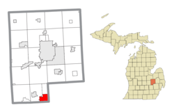 Location within Genesee County | |
 Fenton Location within the state of Michigan | |
| Coordinates: 42°47′52″N 83°42′18″W / 42.79778°N 83.70500°WCoordinates: 42°47′52″N 83°42′18″W / 42.79778°N 83.70500°W | |
| Country | United States |
| State | Michigan |
| Counties | Genesee, Livingston, and Oakland |
| Settled | 1834 |
| Incorporated | 1863 (village) 1964 (city) |
| Government | |
| • Type | Council–manager |
| • Mayor | Sue Osborn |
| • Mayor Pro Tem | Pat Lockwood |
| • City council | Nancy Draves Brad Jacob David McDermott Scott Grossmeyer Pat Lockwood Cherie Smith |
| • City manager | Lynn Markland |
| Area | |
| • Total | 6.97 sq mi (18.07 km2) |
| • Land | 6.65 sq mi (17.23 km2) |
| • Water | 0.32 sq mi (0.84 km2) 4.57% |
| Elevation | 902 ft (275 m) |
| Population | |
| • Total | 11,756 |
| • Estimate (2019)[5] | 11,403 |
| • Density | 1,714.48/sq mi (661.93/km2) |
| Time zone | UTC-5 (Eastern (EST)) |
| • Summer (DST) | UTC-4 (EDT) |
| ZIP code(s) | 48430 |
| Area code(s) | 248 and 810 |
| FIPS code | 26-27760[3] |
| GNIS feature ID | 0625893[4] |
| Website | www |

Fenton is a city in the U.S. state of Michigan that lies mostly in Genesee County, with small portions in neighboring Oakland County and Livingston County.
History[]

It was first established in 1834 and was originally named Dibbleville after Clark Dibble, one of the first settlers. It was platted in 1837 as Fentonville by William M. Fenton[6] who would later become lieutenant-governor of Michigan. When the settlement was incorporated as a village in 1863 the name Fenton was used.[7] The settlement's post office used the name Fentonville from 1837 until 1886, when it adopted the current name.
In the 1970s, the city leveled its downtown buildings and closed Leroy Street as part of an urban renewal plan.[8] On August 24, 2007, an EF2 tornado hit Fenton, damaging several homes and a school, and almost completely destroying the soon to be opened Tractor Supply Company, tearing off its roof. This caused many people to go without power, leaving the city in a state of emergency. There were no fatalities or serious injuries.[9] In July 2011, the first proposed building, Cornerstone, to restore the city's old downtown area was announced.[8] A renovation and expansion of the converted it into a restaurant named The Fenton Fire Hall in December 2013.
As of the 2010 census, the city population was 11,756.[10] The city was incorporated from Fenton Township in Genesee County, and the city and township are administratively autonomous. Fenton includes several historic buildings. It was home to the first aviation school in Michigan and the A.J. Phillips Fenton Museum.[11][12]
Geography[]
According to the United States Census Bureau, the city has a total area of 7.00 square miles (18.13 km2), of which 6.68 square miles (17.30 km2) is land and 0.32 square miles (0.83 km2) (4.57%) is water.[13]
Numerous municipalities in Michigan span two counties, but Fenton is one of two municipalities in the state of Michigan to span three counties; the other being the capital city of Lansing. The overwhelming majority of Fenton is located within Genesee County, with a total area of 6.88 square miles (17.82 km2), of which 6.56 square miles (16.99 km2) is land and 0.32 square miles (0.83 km2) is water. The Genesee County portion represents 98.29% of Fenton's total area and 99.99% of its population. Of Fenton's 11,747 residents, all but 10 residents live in Genesee County. The separate 10 residents live in the Livingston County portion of Fenton, which contains a land area of 0.11 square miles (0.28 km2). A minuscule portion with no residents extends into Oakland County with a total land area of 0.01 square miles (0.03 km2).[14]
The Tipsico Lake Project is a brownfield redevelopment project to restore the land and surrounding area.[15]
Demographics[]
| Historical population | |||
|---|---|---|---|
| Census | Pop. | %± | |
| 1860 | 735 | — | |
| 1870 | 2,353 | 220.1% | |
| 1880 | 2,152 | −8.5% | |
| 1890 | 2,182 | 1.4% | |
| 1900 | 2,408 | 10.4% | |
| 1910 | 2,331 | −3.2% | |
| 1920 | 2,507 | 7.6% | |
| 1930 | 3,171 | 26.5% | |
| 1940 | 3,377 | 6.5% | |
| 1950 | 4,226 | 25.1% | |
| 1960 | 6,142 | 45.3% | |
| 1970 | 8,284 | 34.9% | |
| 1980 | 8,098 | −2.2% | |
| 1990 | 8,444 | 4.3% | |
| 2000 | 10,582 | 25.3% | |
| 2010 | 11,756 | 11.1% | |
| 2019 (est.) | 11,403 | [5] | −3.0% |
| U.S. Decennial Census[16] | |||
2010 census[]
As of the census[2] of 2010, there were 11,756 people, 5,067 households, and 2,953 families living in the city. The population density was 1,759.9 inhabitants per square mile (679.5/km2). There were 5,572 housing units at an average density of 834.1 per square mile (322.0/km2). The racial makeup of the city was 95.1% White, 1.3% African American, 0.3% Native American, 0.7% Asian, 0.5% from other races, and 2.0% from two or more races. Hispanic or Latino of any race were 2.5% of the population.
There were 5,067 households, of which 31.9% had children under the age of 18 living with them, 39.8% were married couples living together, 13.2% had a female householder with no husband present, 5.2% had a male householder with no wife present, and 41.7% were non-families. 34.9% of all households were made up of individuals, and 13.5% had someone living alone who was 65 years of age or older. The average household size was 2.27 and the average family size was 2.96.
The median age in the city was 36 years. 24.1% of residents were under the age of 18; 8.9% were between the ages of 18 and 24; 29.7% were from 25 to 44; 22.8% were from 45 to 64, and 14.4% were 65 years of age or older. The gender makeup of the city was 46.8% male and 53.2% female.
2000 census[]
As of the census[3] of 2000, there were 10,582 people, 4,335 households, and 2,709 families living in the city. The population density was 1,612.5 per square mile (622.8/km2). There were 4,569 housing units at an average density of 696.2 per square mile (268.9/km2). The racial makeup of the city was 96.25% White, 0.60% African American, 0.39% Native American, 0.95% Asian, 0.66% from other races, and 1.16% from two or more races. Hispanic or Latino of any race were 1.80% of the population.
There were 4,335 households, out of which 32.9% had children under the age of 18 living with them, 48.5% were married couples living together, 10.8% had a female householder with no husband present, and 37.5% were non-families. 30.7% of all households were made up of individuals, and 11.2% had someone living alone who was 65 years of age or older. The average household size was 2.38 and the average family size was 3.01.
In the city, the population was spread out, with 25.4% under the age of 18, 8.5% from 18 to 24, 33.7% from 25 to 44, 18.8% from 45 to 64, and 13.6% who were 65 years of age or older. The median age was 34 years. For every 100 females, there were 88.5 males. For every 100 females age 18 and over, there were 85.6 males.
The median income for a household in the city was $47,400, and the median income for a family was $55,637. Males had a median income of $44,874 versus $30,435 for females. The per capita income for the city was $22,435. About 4.4% of families and 6.2% of the population were below the poverty line, including 5.9% of those under age 18 and 12.4% of those age 65 or over.
Government[]
The municipality operates its own water system.[17]
Highways[]
U.S. 23 runs north and south through the city.
Notable people[]
- Cynthia Roberts Gorton (1826–1894), blind poet and author
- Ira W. Jayne (1882–1961), Wayne County Circuit Court Chief Judge
- Ava Michelle (born 2002), American actress best known for her role as Jodi in Tall Girl
Gallery[]

Fenton City Hall
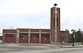
(now a restaurant)
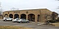
US Post Office
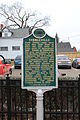
Dibbleville historical marker

A.J. Phillips Building (1900)


References[]
Notes[]
- ^ "2019 U.S. Gazetteer Files". United States Census Bureau. Retrieved July 25, 2020.
- ^ Jump up to: a b "U.S. Census website". United States Census Bureau. Retrieved 2012-11-25.
- ^ Jump up to: a b "U.S. Census website". United States Census Bureau. Retrieved 2008-01-31.
- ^ U.S. Geological Survey Geographic Names Information System: Fenton, Michigan
- ^ Jump up to: a b "Population and Housing Unit Estimates". United States Census Bureau. May 24, 2020. Retrieved May 27, 2020.
- ^ Gannett, Henry (1905). The Origin of Certain Place Names in the United States. Govt. Print. Off. pp. 125.
- ^ Romig 1986, p. 194.
- ^ Jump up to: a b DeFever, Dana (July 13, 2011). "Proposed $4-million project in Fenton to serve as first step to revitalize downtown". The Flint Journal. Retrieved July 15, 2011.
- ^ EXECUTIVE ORDER No. 2007 - 40, DECLARATION OF STATE OF EMERGENCY CITY OF FENTON, GENESEE COUNTY
- ^ "Race, Hispanic or Latino, Age, and Housing Occupancy: 2010 Census Redistricting Data (Public Law 94-171) Summary File (QT-PL), Fenton city, Michigan". United States Census Bureau. Retrieved August 18, 2011.
- ^ Fenton by Donna Seger, Kenneth Seger 2009
- ^ Fenton Museum City of Fenton
- ^ "US Gazetteer files 2010". United States Census Bureau. Archived from the original on 2012-01-25. Retrieved 2012-11-25.
- ^ "Michigan: 2010 Population and Housing Unit Counts 2010 Census of Population and Housing" (PDF). 2010 United States Census. United States Census Bureau. September 2012. pp. Michigan 21, 30, 36, and 64. Retrieved April 23, 2020.
- ^ City of Fenton Brownfield Redevelopment Authority. "Brownfield Redevelopment Authority". City of Fenton. Tipsico Lake Road Project. Retrieved 31 October 2011.
- ^ "Census of Population and Housing". Census.gov. Retrieved June 4, 2015.
- ^ Adams, Dominic (June 27, 2014). "Flint monthly water and sewer bills highest in Genesee County by $35". The Flint Journal. Mlive Media Group. Retrieved April 2, 2015.
Sources[]
- Romig, Walter (October 1, 1986) [1973]. Michigan Place Names: The History of the Founding and the Naming of More Than Five Thousand Past and Present Michigan Communities. Great Lakes Books Series (Paperback). Detroit, Michigan: Wayne State University Press. ISBN 978-0-8143-1838-6.
External links[]
| show Municipalities and communities of Genesee County, Michigan, United States |
|---|

| show Municipalities and communities of Oakland County, Michigan, United States |
|---|

| show Municipalities and communities of Livingston County, Michigan, United States |
|---|

| show Authority control |
|---|
- Cities in Genesee County, Michigan
- Cities in Livingston County, Michigan
- Cities in Oakland County, Michigan
- Metro Detroit
- Populated places established in 1834
- 1834 establishments in Michigan Territory