Stow Creek Township, New Jersey
Stow Creek Township, New Jersey | |
|---|---|
| Township of Stow Creek | |
 Cohansey Baptist Church | |
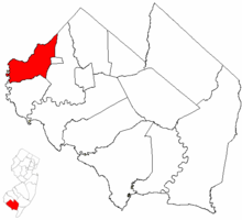 Stow Creek Township highlighted in Cumberland County. Inset map: Cumberland County highlighted in the State of New Jersey. | |
 Census Bureau map of Stow Creek Township, New Jersey | |
 Stow Creek Township Location in Cumberland County | |
| Coordinates: 39°27′22″N 75°21′18″W / 39.456196°N 75.355016°WCoordinates: 39°27′22″N 75°21′18″W / 39.456196°N 75.355016°W[1][2] | |
| Country | |
| State | |
| County | |
| Formed | January 19, 1748 |
| Incorporated | February 21, 1798 |
| Government | |
| • Type | Township |
| • Body | Township Committee |
| • Mayor | Randy Dickenson Jr. (R, term ends December 31, 2020)[3][4] |
| • Municipal clerk | Bruce Porter[5] |
| Area | |
| • Total | 18.89 sq mi (48.93 km2) |
| • Land | 18.27 sq mi (47.31 km2) |
| • Water | 0.63 sq mi (1.62 km2) 3.32% |
| Area rank | 151st of 565 in state 10th of 14 in county[1] |
| Elevation | 69 ft (21 m) |
| Population | |
| • Total | 1,431 |
| • Estimate (2019)[11] | 1,370 |
| • Rank | 516th of 566 in state 12th of 14 in county[12] |
| • Density | 78.2/sq mi (30.2/km2) |
| • Density rank | 551st of 566 in state 12th of 14 in county[12] |
| Time zone | UTC−05:00 (Eastern (EST)) |
| • Summer (DST) | UTC−04:00 (Eastern (EDT)) |
| ZIP Code | |
| Area code(s) | 856[14] |
| FIPS code | 3401171160[1][15][16] |
| GNIS feature ID | 0882057[1][17] |
| Website | www |


Stow Creek Township is a township in Cumberland County, New Jersey, United States. It is part of the Vineland-Millville-Bridgeton Primary Metropolitan Statistical Area for statistical purposes. As of the 2010 United States Census, the township had a total population of 1,431,[8][9][10] reflecting an increase of 2 (+0.1%) from the 1,429 counted in the 2000 Census, which had in turn declined by 8 (-0.6%) from the 1,437 counted in the 1990 Census.[18]
It is a dry township, where alcohol cannot be sold.[19][20]
History[]
Stow Creek dates back to January 19, 1748, when it was formed as one of six precincts in the newly created Cumberland County. It was formally incorporated as a township on February 21, 1798.[21]
As part of a political battle over the site of the county seat for Cumberland County, Columbia Township was formed on March 12, 1844, from portions of Hopewell and Stow Creek Townships; the short-lived municipality included all of present-day Shiloh, in addition to extensive additional land, but all was returned to its original home when Columbia Township was dissolved on March 11, 1845, surviving as an independent municipality for a day short of one year.[21][22]
The spelling of the township's name was changed from "Stoe Creek" to "Stow Creek" on October 1, 1924.[23]
On April 9, 1929, portions of the township were taken to create Shiloh. On October 1, 1924, the New Jersey Legislature officially changed the name of the township from "Stoe Creek" to "Stow Creek", though it is unclear when "Stow" had become "Stoe".[21]
The township's name is shared with the Stow Creek, a tributary of the Delaware River.
Geography[]
According to the United States Census Bureau, the township had a total area of 18.89 square miles (48.93 km2), including 18.27 square miles (47.31 km2) of land and 0.63 square miles (1.62 km2) of water (3.32%).[1][2]
Unincorporated communities, localities and place names located partially or completely within the township include Arrowhead Lake, Cumberland Causeway, Garrisons Corner, Gum Tree Corner, Jericho, Kernans Corner, Macanippock, Marlboro, Roadstown, Seventh Day Mill, Stow Creek Landing, Town Hall and Willis Corner.[24][25]
The township borders the municipalities of Hopewell Township, Greenwich Township and Shiloh in Cumberland County; and Alloway Township, Lower Alloways Creek Township and Quinton Township in Salem County.[26][27]
Demographics[]
| Historical population | |||
|---|---|---|---|
| Census | Pop. | %± | |
| 1810 | 1,039 | — | |
| 1820 | 884 | −14.9% | |
| 1830 | 791 | −10.5% | |
| 1840 | 846 | 7.0% | |
| 1850 | 1,093 | 29.2% | |
| 1860 | 1,267 | 15.9% | |
| 1870 | 1,122 | −11.4% | |
| 1880 | 1,107 | −1.3% | |
| 1890 | 972 | −12.2% | |
| 1900 | 934 | −3.9% | |
| 1910 | 880 | −5.8% | |
| 1920 | 844 | −4.1% | |
| 1930 | 796 | * | −5.7% |
| 1940 | 720 | −9.5% | |
| 1950 | 957 | 32.9% | |
| 1960 | 1,010 | 5.5% | |
| 1970 | 1,050 | 4.0% | |
| 1980 | 1,365 | 30.0% | |
| 1990 | 1,437 | 5.3% | |
| 2000 | 1,429 | −0.6% | |
| 2010 | 1,431 | 0.1% | |
| 2019 (est.) | 1,370 | [11][28] | −4.3% |
| Population sources: 1810-2010[29][30] 1810-1920[31] 1840[32] 1850-1870[33] 1850[34] 1870[35] 1880-1890[36] 1890-1910[37] 1910-1930[38] 1930-1990[39] 2000[40][41] 2010[8][9][10] * = Lost territory in previous decade.[21] | |||
Census 2010[]
The 2010 United States census counted 1,431 people, 543 households, and 412 families in the township. The population density was 78.2 per square mile (30.2/km2). There were 568 housing units at an average density of 31.0 per square mile (12.0/km2). The racial makeup was 91.33% (1,307) White, 4.47% (64) Black or African American, 1.40% (20) Native American, 0.28% (4) Asian, 0.00% (0) Pacific Islander, 0.98% (14) from other races, and 1.54% (22) from two or more races. Hispanic or Latino of any race were 4.40% (63) of the population.[8]
Of the 543 households, 26.2% had children under the age of 18; 61.7% were married couples living together; 8.7% had a female householder with no husband present and 24.1% were non-families. Of all households, 19.2% were made up of individuals and 9.9% had someone living alone who was 65 years of age or older. The average household size was 2.64 and the average family size was 3.01.[8]
20.8% of the population were under the age of 18, 8.0% from 18 to 24, 21.5% from 25 to 44, 32.1% from 45 to 64, and 17.6% who were 65 years of age or older. The median age was 44.6 years. For every 100 females, the population had 101.0 males. For every 100 females ages 18 and older there were 97.9 males.[8]
The Census Bureau's 2006-2010 American Community Survey showed that (in 2010 inflation-adjusted dollars) median household income was $71,333 (with a margin of error of +/- $7,849) and the median family income was $78,583 (+/- $7,836). Males had a median income of $52,500 (+/- $12,034) versus $38,036 (+/- $3,668) for females. The per capita income for the borough was $29,860 (+/- $3,146). About 4.1% of families and 6.8% of the population were below the poverty line, including 10.3% of those under age 18 and 4.3% of those age 65 or over.[42]
Census 2000[]
As of the 2000 United States Census[15] there were 1,429 people, 536 households, and 425 families residing in the township. The population density was 77.5 people per square mile (29.9/km2). There were 560 housing units at an average density of 30.4 per square mile (11.7/km2). The racial makeup of the township was 93.42% White, 3.50% African American, 1.61% Native American, 0.21% Asian, 0.84% from other races, and 0.42% from two or more races. Hispanic or Latino of any race were 1.68% of the population.[40][41]
There were 536 households, out of which 32.1% had children under the age of 18 living with them, 69.0% were married couples living together, 6.7% had a female householder with no husband present, and 20.7% were non-families. 17.9% of all households were made up of individuals, and 7.5% had someone living alone who was 65 years of age or older. The average household size was 2.67 and the average family size was 3.01.[40][41]
In the township the population was spread out, with 23.5% under the age of 18, 7.2% from 18 to 24, 25.8% from 25 to 44, 29.0% from 45 to 64, and 14.5% who were 65 years of age or older. The median age was 41 years. For every 100 females, there were 96.8 males. For every 100 females age 18 and over, there were 92.8 males.[40][41]
The median income for a household in the township was $52,500, and the median income for a family was $58,583. Males had a median income of $35,500 versus $26,528 for females. The per capita income for the township was $20,925. About 5.7% of families and 6.7% of the population were below the poverty line, including 8.1% of those under age 18 and 12.1% of those age 65 or over.[40][41]
Government[]
Local government[]
Stow Creek is governed under the Township form of New Jersey municipal government, one of 141 municipalities (of the 565) statewide that use this form, the second-most commonly used form of government in the state.[43] The governing body is comprised of a three-member Township Committee, whose members are elected directly by the voters at-large in partisan elections to serve three-year terms of office on a staggered basis, with one seat coming up for election each year as part of the November general election in a three-year cycle.[6][44] At an annual reorganization meeting, the Township Committee selects one of its members to serve as Mayor.
As of 2020, members of the Stow Creek Township Committee are Mayor Melvin R. "Randy" Dickinson Jr. (R, term on committee ends December 31, 2021; term as mayor ends 2020), Thomas R. Burton (R, 2019) and Dale F. Cruzan Sr. (R, 2020).[3][45][46][47][48][49]
Federal, state and county representation[]
Stow Creek Township is located in the 2nd Congressional District[50] and is part of New Jersey's 1st state legislative district.[9][51][52] Prior to the 2011 reapportionment following the 2010 Census, Stow Creek Township had been in the 3rd state legislative district.[53]
For the 117th United States Congress, New Jersey's Second Congressional District is represented by Jeff Van Drew (R, Dennis Township).[54] New Jersey is represented in the United States Senate by Democrats Cory Booker (Newark, term ends 2027)[55] and Bob Menendez (Harrison, term ends 2025).[56][57]
For the 2020–2021 session (Senate, General Assembly), the 1st Legislative District of the New Jersey Legislature is represented in the State Senate by Mike Testa (R, Vineland) and in the General Assembly by Antwan McClellan (R, Ocean City) and Erik K. Simonsen (R, Lower Township).[58][59]
Cumberland County is governed by a seven-member Board of Chosen Freeholders, who are elected at-large in partisan elections to serve staggered three-year terms in office, with either two or three seats coming up for election each year in a three-year cycle. At an annual reorganization meeting held each January, the freeholders select one member to serve as Freeholder Director and another as Deputy Director.[60] As of 2018, Cumberland County's Freeholders are Freeholder Director Joseph Derella Jr. (D, Millville, term as freeholder and as freeholder director ends December 31, 2018),[61] Deputy Freeholder Director Darlene R. Barber (D, Upper Deerfield Township, term as freeholder ends 2019, term as deputy freeholder director ends 2018),[62] George Castellini (D, Vineland, 2020),[63] Carol Musso (D, Deerfield Township, 2020),[64] James F. Quinn (D, Millville, 2018),[65] Joseph V. Sparacio (R, Deerfield Township, 2019)[66] and Jack Surrency (D, Bridgeton 2020).[67][68][69][70] The county's constitutional officers are Clerk Celeste Riley (D, Bridgeton, 2019),[71][72] Sheriff Robert A. Austino (D, Vineland, 2020)[73][74] and Surrogate Douglas M. Rainear (D, Upper Deerfield Township, 2018).[75][76][69]
Politics[]
As of March 23, 2011, there were a total of 979 registered voters in Stow Creek Township, of which 200 (20.4%) were registered as Democrats, 362 (37.0%) were registered as Republicans and 416 (42.5%) were registered as Unaffiliated. There was one voter registered to another party.[77]
In the 2012 presidential election, Republican Mitt Romney received 64.9% of the vote (447 cast), ahead of Democrat Barack Obama with 34.5% (238 votes), and other candidates with 0.6% (4 votes), among the 697 ballots cast by the township's 982 registered voters (8 ballots were spoiled), for a turnout of 71.0%.[78][79] In the 2008 presidential election, Republican John McCain received 58.5% of the vote (431 cast), ahead of Democrat Barack Obama, who received 38.4% (283 votes), with 737 ballots cast among the township's 979 registered voters, for a turnout of 75.3%.[80] In the 2004 presidential election, Republican George W. Bush received 64.6% of the vote (455 ballots cast), outpolling Democrat John Kerry, who received around 34.4% (242 votes), with 704 ballots cast among the township's 915 registered voters, for a turnout percentage of 76.9.[81]
In the 2013 gubernatorial election, Republican Chris Christie received 75.1% of the vote (355 cast), ahead of Democrat Barbara Buono with 24.1% (114 votes), and other candidates with 0.8% (4 votes), among the 483 ballots cast by the township's 942 registered voters (10 ballots were spoiled), for a turnout of 51.3%.[82][83] In the 2009 gubernatorial election, Republican Chris Christie received 60.6% of the vote (308 ballots cast), ahead of both Democrat Jon Corzine with 29.1% (148 votes) and Independent Chris Daggett with 6.3% (32 votes), with 508 ballots cast among the township's 962 registered voters, yielding a 52.8% turnout.[84]
Education[]
The Stow Creek School District serves public school students in kindergarten through eighth grade at Stow Creek School. As of the 2017–18 school year, the district, comprised of one school, had an enrollment of 111 students and 21.6 classroom teachers (on an FTE basis), for a student–teacher ratio of 5.1:1.[85] In the 2016–17 school year, it had the 13th-smallest enrollment of any school district in the state.[86] Under the Greenwich - Stow Creek Partnership established in 2009 with the Greenwich Township School District in Greenwich Township, students from both townships attend Morris Goodwin School for grades K-4 and Stow Creek School for grades 5–8.[87]
Public school students in ninth through twelfth grades attend Cumberland Regional High School, which also serves students from Deerfield Township, Fairfield Township, Greenwich Township, Hopewell Township, Shiloh Borough and Upper Deerfield Township.[88][89][90] As of the 2017–18 school year, the high school had an enrollment of 1,127 students and 78.5 classroom teachers (on an FTE basis), for a student–teacher ratio of 14.4:1.[91] The high school district has a nine-member board of education, with board seats allocated to the constituent municipalities based on population, with each municipality assigned a minimum of one seat; Stow Creek Township has one seat on the board.[92][93][94]
Students are also eligible to attend Cumberland County Technology Education Center in Vineland, serving students from the entire county in its full-time technical training programs, which are offered without charge to students who are county residents.[95]
Transportation[]

As of May 2010, the township had a total of 44.04 miles (70.88 km) of roadways, of which 10.66 miles (17.16 km) were maintained by the municipality, 31.24 miles (50.28 km) by Cumberland County and 2.14 miles (3.44 km) by the New Jersey Department of Transportation.[96]
New Jersey Route 49 is the main highway providing access to Stow Creek.[97]
References[]
- ^ Jump up to: a b c d e f 2019 Census Gazetteer Files: New Jersey Places, United States Census Bureau. Accessed July 1, 2020.
- ^ Jump up to: a b US Gazetteer files: 2010, 2000, and 1990, United States Census Bureau. Accessed September 4, 2014.
- ^ Jump up to: a b Township Committee, Stow Creek Township. Accessed March 6, 2020.
- ^ 2020 New Jersey Mayors Directory, New Jersey Department of Community Affairs. Accessed February 1, 2020.
- ^ Clerk & Other Officials, Stow Creek Township. Accessed November 1, 2019.
- ^ Jump up to: a b 2012 New Jersey Legislative District Data Book, Rutgers University Edward J. Bloustein School of Planning and Public Policy, March 2013, p. 103.
- ^ U.S. Geological Survey Geographic Names Information System: Township of Stow Creek, Geographic Names Information System. Accessed March 14, 2013.
- ^ Jump up to: a b c d e f DP-1 - Profile of General Population and Housing Characteristics: 2010 for Stow Creek township, Cumberland County, New Jersey Archived February 12, 2020, at archive.today, United States Census Bureau. Accessed October 24, 2012.
- ^ Jump up to: a b c d Municipalities Sorted by 2011-2020 Legislative District, New Jersey Department of State. Accessed February 1, 2020.
- ^ Jump up to: a b c Profile of General Demographic Characteristics: 2010 for Stow Creek township[permanent dead link], New Jersey Department of Labor and Workforce Development. Accessed October 24, 2012.
- ^ Jump up to: a b Annual Estimates of the Resident Population for Minor Civil Divisions in New Jersey: April 1, 2010 to July 1, 2019, United States Census Bureau. Accessed May 21, 2020.
- ^ Jump up to: a b GCT-PH1 Population, Housing Units, Area, and Density: 2010 - State -- County Subdivision from the 2010 Census Summary File 1 for New Jersey Archived February 12, 2020, at archive.today, United States Census Bureau. Accessed October 24, 2012.
- ^ Look Up a ZIP Code for Bridgeton, NJ, United States Postal Service. Accessed October 24, 2012.
- ^ Area Code Lookup - NPA NXX for Stow Creek, NJ, Area-Codes.com. Accessed October 28, 2014.
- ^ Jump up to: a b U.S. Census website , United States Census Bureau. Accessed September 4, 2014.
- ^ Geographic codes for New Jersey, Missouri Census Data Center. Accessed September 1, 2019.
- ^ US Board on Geographic Names, United States Geological Survey. Accessed September 4, 2014.
- ^ Table 7. Population for the Counties and Municipalities in New Jersey: 1990, 2000 and 2010, New Jersey Department of Labor and Workforce Development, February 2011. Accessed October 24, 2012.
- ^ New Jersey Division of Alcoholic Beverage Control. New Jersey ABC list of dry towns (May 1, 2013)
- ^ Giordano, Rita. "More towns catching liquor-license buzz; Moorestown considers ending its dry spell", The Philadelphia Inquirer, June 24, 2007. Accessed February 16, 2014.
- ^ Jump up to: a b c d Snyder, John P. The Story of New Jersey's Civil Boundaries: 1606-1968, Bureau of Geology and Topography; Trenton, New Jersey; 1969. p. 122. Accessed October 24, 2012.
- ^ About Shiloh, Borough of Shiloh. Accessed November 1, 2019. "In 1837, to settle a tie on the Board of Freeholders as to whether to move the county seat from Bridgeton to Millville, a new municipality called Columbia Township was formed in Shiloh. The new Columbia Freeholder voted to keep the county seat in Bridgeton and the community of Shiloh was again split into Hopewell and Stow Creek."
- ^ About Us, Stow Creek Township. Accessed November 1, 2019. "On October 1, 1924, the New Jersey Legislature officially changed the name of the township from 'Stoe Creek' to 'Stow Creek'."
- ^ Locality Search, State of New Jersey. Accessed December 28, 2014.
- ^ Gannett, Henry (January 28, 1895). "A Geographic Dictionary of New Jersey". U.S. Government Printing Office – via Google Books.
- ^ Map of Cumberland County, New Jersey Department of Transportation. Accessed October 28, 2019.
- ^ New Jersey Municipal Boundaries, New Jersey Department of Transportation. Accessed November 15, 2019.
- ^ Census Estimates for New Jersey April 1, 2010 to July 1, 2019, United States Census Bureau. Accessed May 21, 2020.
- ^ Barnett, Bob. Population Data for Cumberland County Municipalities, 1810 - 2010, WestJersey.org. January 6, 2011. Accessed October 24, 2012.
- ^ Cumberland County, NJ Data Book 2016, Cumberland County, New Jersey. Accessed October 31, 2019.
- ^ Compendium of censuses 1726-1905: together with the tabulated returns of 1905, New Jersey Department of State, 1906. Accessed August 19, 2013.
- ^ Bowen, Francis. American Almanac and Repository of Useful Knowledge for the Year 1843, p. 232, David H. Williams, 1842. Accessed August 19, 2013.
- ^ Raum, John O. The History of New Jersey: From Its Earliest Settlement to the Present Time, Volume 1, p. 270, J. E. Potter and company, 1877. Accessed August 19, 2013. "Stoe Creek contained a population in 1850 of 1,093; in 1860, 1,267; and in 1870, 1,122. It forms considerable of the boundary between Salem and Cumberland counties."
- ^ Debow, James Dunwoody Brownson. The Seventh Census of the United States: 1850, p. 137. R. Armstrong, 1853. Accessed August 19, 2013.
- ^ Staff. A compendium of the ninth census, 1870, p. 259. United States Census Bureau, 1872. Accessed August 19, 2013.
- ^ Porter, Robert Percival. Preliminary Results as Contained in the Eleventh Census Bulletins: Volume III - 51 to 75, p. 97. United States Census Bureau, 1890. Accessed August 19, 2013.
- ^ Thirteenth Census of the United States, 1910: Population by Counties and Minor Civil Divisions, 1910, 1900, 1890, United States Census Bureau, p. 336. Accessed October 24, 2012.
- ^ Fifteenth Census of the United States : 1930 - Population Volume I, United States Census Bureau, p. 715. Accessed October 24, 2012.
- ^ New Jersey Resident Population by Municipality: 1930 - 1990, Workforce New Jersey Public Information Network. Accessed June 28, 2015.
- ^ Jump up to: a b c d e Census 2000 Profiles of Demographic / Social / Economic / Housing Characteristics for Stow Creek township, Cumberland County, New Jersey[permanent dead link], United States Census Bureau. Accessed October 24, 2012.
- ^ Jump up to: a b c d e DP-1: Profile of General Demographic Characteristics: 2000 - Census 2000 Summary File 1 (SF 1) 100-Percent Data for Stow Creek township, Cumberland County, New Jersey Archived February 12, 2020, at archive.today, United States Census Bureau. Accessed October 24, 2012.
- ^ DP03: Selected Economic Characteristics from the 2006-2010 American Community Survey 5-Year Estimates for Stow Creek township, Cumberland County, New Jersey Archived February 12, 2020, at archive.today, United States Census Bureau. Accessed October 24, 2012.
- ^ Inventory of Municipal Forms of Government in New Jersey, Rutgers University Center for Government Studies, July 1, 2011. Accessed November 18, 2019.
- ^ "Forms of Municipal Government in New Jersey", p. 7. Rutgers University Center for Government Studies. Accessed June 3, 2015.
- ^ 2019 Municipal User Friendly Budget for Stow Creek Township, Burlington County, New Jersey Department of Community Affairs. Accessed November 1, 2019.
- ^ 2018 Directory of Cumberland County, New Jersey, Cumberland County, New Jersey. Accessed September 15, 2019.
- ^ General Election Results November 5, 2019, Official Results, Cumberland County, New Jersey, updated November 14, 2019. Accessed January 1, 2020.
- ^ General Election Results November 6, 2018, Official Results, Cumberland County, New Jersey, updated November 19, 2018. Accessed January 1, 2019.
- ^ General Election Results November 7, 2017, Official Results, Cumberland County, New Jersey, updated November 28, 2017. Accessed January 1, 2018.
- ^ Plan Components Report, New Jersey Redistricting Commission, December 23, 2011. Accessed February 1, 2020.
- ^ 2019 New Jersey Citizen's Guide to Government, New Jersey League of Women Voters. Accessed October 30, 2019.
- ^ Districts by Number for 2011-2020, New Jersey Legislature. Accessed January 6, 2013.
- ^ 2011 New Jersey Citizen's Guide to Government Archived June 4, 2013, at the Wayback Machine, p. 65, New Jersey League of Women Voters. Accessed May 22, 2015.
- ^ Directory of Representatives: New Jersey, United States House of Representatives. Accessed January 3, 2019.
- ^ [1], United States Senate. Accessed April 30, 2021. "He now owns a home and lives in Newark's Central Ward community."
- ^ Biography of Bob Menendez, United States Senate, January 26, 2015. "Menendez, who started his political career in Union City, moved in September from Paramus to one of Harrison's new apartment buildings near the town's PATH station.."
- ^ [2]. United States Senate. Accessed April 30, 2021. "Booker, Cory A. - (D - NJ) Class II; Menendez, Robert - (D - NJ) Class I"
- ^ Legislative Roster 2020–2021 Session, New Jersey Legislature. Accessed April 16, 2020.
- ^ District 1 Legislators, New Jersey Legislature. Accessed April 16, 2020.
- ^ About Cumberland County Government, Cumberland County, New Jersey. Accessed June 7, 2018. "By law, Cumberland County is allowed 7 freeholders, who serve staggered, overlapping three year terms. Two are elected in two successive years, three in the third year, elected from the county at-large. A Director of the Board is selected by his colleagues for a one year term."
- ^ Joseph Derella, Cumberland County, New Jersey. Accessed June 7, 2018.
- ^ Darlene Barber, Cumberland County, New Jersey. Accessed June 7, 2018.
- ^ George Castellini, Cumberland County, New Jersey. Accessed June 7, 2018.
- ^ Carol Musso, Cumberland County, New Jersey. Accessed June 7, 2018.
- ^ James F. Quinn, Cumberland County, New Jersey. Accessed June 7, 2018.
- ^ Joseph V. Sparacio, Cumberland County, New Jersey. Accessed June 7, 2018.
- ^ Jack Surrency, Cumberland County, New Jersey. Accessed June 7, 2018.
- ^ The Cumberland County Board of Chosen Freeholders, Cumberland County, New Jersey. Accessed June 7, 2018.
- ^ Jump up to: a b 2018 Directory of Cumberland County, New Jersey, Cumberland County, New Jersey. Accessed June 7, 2018.
- ^ 2018 County Data Sheet, Cumberland County, New Jersey. Accessed June 7, 2018.
- ^ County Clerk: Celeste M. Riley, Cumberland County Clerk's Office. Accessed June 7, 2018.
- ^ Members List: Clerks, Constitutional Officers Association of New Jersey. Accessed June 7, 2018.
- ^ Sheriff's Office, Cumberland County, New Jersey. Accessed June 7, 2018.
- ^ Members List: Sheriffs, Constitutional Officers Association of New Jersey. Accessed June 7, 2018.
- ^ Cumberland County Surrogate Office, Cumberland County, New Jersey. Accessed June 7, 2018.
- ^ Members List: Surrogates, Constitutional Officers Association of New Jersey. Accessed June 7, 2018.
- ^ Voter Registration Summary - Cumberland, New Jersey Department of State Division of Elections, March 23, 2011. Accessed October 24, 2012.
- ^ "Presidential General Election Results - November 6, 2012 - Cumberland County" (PDF). New Jersey Department of Elections. March 15, 2013. Retrieved December 24, 2014.
- ^ "Number of Registered Voters and Ballots Cast - November 6, 2012 - General Election Results - Cumberland County" (PDF). New Jersey Department of Elections. March 15, 2013. Retrieved December 24, 2014.
- ^ 2008 Presidential General Election Results: Cumberland County, New Jersey Department of State Division of Elections, December 23, 2008. Accessed October 24, 2012.
- ^ 2004 Presidential Election: Cumberland County, New Jersey Department of State Division of Elections, December 13, 2004. Accessed October 24, 2012.
- ^ "Governor - Cumberland County" (PDF). New Jersey Department of Elections. January 29, 2014. Retrieved December 24, 2014.
- ^ "Number of Registered Voters and Ballots Cast - November 5, 2013 - General Election Results - Cumberland County" (PDF). New Jersey Department of Elections. January 29, 2014. Retrieved December 24, 2014.
- ^ 2009 Governor: Cumberland County Archived July 7, 2016, at the Wayback Machine, New Jersey Department of State Division of Elections, December 31, 2009. Accessed October 24, 2012.
- ^ District information for Stow Creek Township School District, National Center for Education Statistics. Accessed November 1, 2019.
- ^ Guion, Payton. "These 43 N.J. school districts have fewer than 200 students", NJ Advance Media for NJ.com, September 2017. Accessed January 30, 2020. "Based on data from the state Department of Education from the last school year and the Census Bureau, NJ Advance Media made a list of the smallest of the small school districts in the state, excluding charter schools and specialty institutions.... 13. Stow Creek Township - Enrollment: 123; Grades: K-8; County: Cumberland"
- ^ Greenwich - Stow Creek Partnership Schools K-8, Greenwich Township. Accessed March 25, 2017. "In 2009, the Morris Goodwin School entered into a shared services agreement with neighboring Stow Creek School in Stow Creek Township to form the Greenwich-Stow Creek Partnership Schools. Public school students in grades K through 4 now attend Morris Goodwin School and students in grades 5 through 8 attend Stow Creek School."
- ^ Cumberland Regional School District 2015 Report Card Narrative, New Jersey Department of Education. Accessed June 5, 2016. "The Cumberland Regional School District, located in Western Cumberland County, provides students with a comprehensive learning environment in a nurturing and personalized setting. The district serves students in grades 9-12 who reside in the municipalities of Deerfield, Fairfield, Greenwich & Stow Creek, Hopewell & Shiloh, and Upper Deerfield."
- ^ Shott, Meghan. "Cumberland Regional High School", South Jersey magazine. Accessed June 5, 2016. "Cumberland Regional High School, located in the northwest part of Cumberland County, serves students from Deerfield Township, Fairfield Township, Greenwich Township, Hopewell Township, Shiloh Borough, Stow Creek Township and Upper Deerfield Township."
- ^ Constituent Districts[permanent dead link], Cumberland Regional High School. Accessed June 5, 2016.
- ^ School data for Cumberland Regional High School, National Center for Education Statistics. Accessed November 1, 2019.
- ^ New Jersey Boards of Education by District Election Types - 2018 School Election, New Jersey Department of Education, updated February 16, 2018. Accessed January 26, 2020.
- ^ Comprehensive Annual Financial Report of the Cumberland Regional High School District, New Jersey Department of Education, for year ending June 30, 2018. Accessed March 6, 2020. "The Cumberland Regional Board of Education is a Type II district located in the County of Cumberland, State of New Jersey. As a Type II District, the School District functions independently through a Board of Education. The board is comprised of nine members elected to three-year terms. The purpose of the district is to educate students in grades 9-12."
- ^ Board of Education, Cumberland Regional High School. Accessed March 6, 2020. "The Cumberland Regional School District is led by a nine-member Board of Education representing Cumberland Regional High School's constituent district municipalities: Deerfield Township, Fairfield Township, Greenwich Township, Hopewell Township, Shiloh Borough, Stow Creek Township, and Upper Deerfield Township."
- ^ Admissions, Cumberland County Technology Education Center. Accessed October 30, 2019. "We specialize in technical education to offer students a chance to explore various careers and assist them in developing the skills they need to be successful. We are a full-time high school in a state of the art facility designed to maximize learning and hands on skills."
- ^ Cumberland County Mileage by Municipality and Jurisdiction, New Jersey Department of Transportation, May 2010. Accessed July 18, 2014.
- ^ Route 49 Straight Line Diagram, New Jersey Department of Transportation, updated May 2017. Accessed November 1, 2019.
External links[]
| Wikimedia Commons has media related to Stow Creek Township, New Jersey. |
- Township website
- Greenwich Stow Creek Partnership Schools
- Stow Creek School's 2015–16 School Report Card from the New Jersey Department of Education
- School Data for the Stow Creek School, National Center for Education Statistics
- Cumberland Regional High School
| hide Municipalities and communities of Cumberland County, New Jersey, United States | ||
|---|---|---|
| Cities |  | |
| Borough | ||
| Townships | ||
| CDPs |
| |
| Other communities | ||
| Footnotes | ‡This populated place also has portions in an adjacent county or counties | |
| ||
- Stow Creek Township, New Jersey
- 1748 establishments in New Jersey
- Populated places established in 1748
- Township form of New Jersey government
- Townships in Cumberland County, New Jersey