Sugar Notch, Pennsylvania
Sugar Notch, Pennsylvania | |
|---|---|
Borough | |
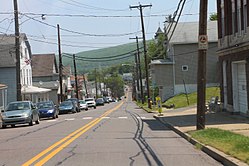 Street in Sugar Notch | |
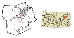 Location of Sugar Notch in Luzerne County, Pennsylvania. | |
 Sugar Notch Location of Sugar Notch in Luzerne County, Pennsylvania.  Sugar Notch Sugar Notch (the United States) | |
| Coordinates: 41°11′46″N 75°55′50″W / 41.19611°N 75.93056°WCoordinates: 41°11′46″N 75°55′50″W / 41.19611°N 75.93056°W | |
| Country | United States |
| State | Pennsylvania |
| County | Luzerne |
| Incorporated | 1867 |
| Government | |
| • Type | Borough Council |
| • Mayor | |
| Area | |
| • Total | 0.99 sq mi (2.58 km2) |
| • Land | 0.99 sq mi (2.58 km2) |
| • Water | 0.00 sq mi (0.00 km2) |
| Population (2010) | |
| • Total | 989 |
| • Estimate (2019)[2] | 962 |
| • Density | 966.83/sq mi (373.20/km2) |
| Time zone | UTC-5 (Eastern (EST)) |
| • Summer (DST) | UTC-4 (EDT) |
| Zip code | 18706 |
| Area code(s) | 570 |
| FIPS code | 42-75072 |
| Website | www |
Sugar Notch is a borough in Luzerne County, Pennsylvania, United States. The population was 989 at the 2010 census.[3]
History[]

Sugar Notch was incorporated as a borough on April 3, 1867; it was named for the sugar maple trees surrounding the community. It was originally part of Hanover Township. The first burgess was Charles Parrish and the first council was composed of David Caird, Henry B. Plumb, Samuel Roberts, Adam Shiedel, and George Cyphers.[4]
In 1869, the Lehigh and Susquehanna Railroad was constructed near the borough; it was used to transport coal. Sugar Notch was a popular coal mining community in the 1800s and 1900s. The current municipal building was built in 1921.[5]
Following World War II — in 1946 — the Roosevelt Memorial was dedicated within the borough; Eleanor Roosevelt attended the ceremony.[5]
Geography[]
Sugar Notch is located at 41°11′46″N 75°55′50″W / 41.19611°N 75.93056°W (41.196149, -75.930448).[6]
According to the United States Census Bureau, the borough has a total area of 1.1 square miles (2.8 km2), all of it land.
Demographics[]
| Historical population | |||
|---|---|---|---|
| Census | Pop. | %± | |
| 1870 | 724 | — | |
| 1880 | 1,582 | 118.5% | |
| 1890 | 2,586 | 63.5% | |
| 1900 | 1,887 | −27.0% | |
| 1910 | 2,439 | 29.3% | |
| 1920 | 2,612 | 7.1% | |
| 1930 | 2,768 | 6.0% | |
| 1940 | 2,505 | −9.5% | |
| 1950 | 2,002 | −20.1% | |
| 1960 | 1,524 | −23.9% | |
| 1970 | 1,333 | −12.5% | |
| 1980 | 1,191 | −10.7% | |
| 1990 | 1,044 | −12.3% | |
| 2000 | 1,023 | −2.0% | |
| 2010 | 989 | −3.3% | |
| 2019 (est.) | 962 | [2] | −2.7% |
| Sources:[7][8][9] | |||
As of the census[8] of 2000, there were 1,023 people, 417 households, and 288 families residing in the borough. The population density was 1,002.8 people per square mile (387.2/km2). There were 459 housing units at an average density of 449.9 per square mile (173.7/km2).
The racial makeup of the borough was 99.41% White, 0.10% Asian, 0.10% from other races, and 0.39% from two or more races. Hispanic or Latino of any race were 0.29% of the population.
There were 417 households, out of which 25.2% had children under the age of 18 living with them, 48.9% were married couples living together, 16.3% had a female householder with no husband present, and 30.9% were non-families.
27.3% of all households were made up of individuals, and 16.8% had someone living alone who was 65 years of age or older. The average household size was 2.45 and the average family size was 2.97.
In the borough the population was spread out, with 19.5% under the age of 18, 7.9% from 18 to 24, 27.9% from 25 to 44, 23.1% from 45 to 64, and 21.7% who were 65 years of age or older. The median age was 42 years. For every 100 females there were 92.7 males. For every 100 females age 18 and over, there were 85.2 males.
The median income for a household in the borough was $33,125, and the median income for a family was $38,906. Males had a median income of $30,430 versus $21,563 for females. The per capita income for the borough was $15,902. About 8.0% of families and 9.3% of the population were below the poverty line, including 18.5% of those under age 18 and 6.0% of those age 65 or over.
The borough's population peaked in 1930 (with 2,768 residents). The population of Sugar Notch has been in constant decline since that decade. The population had fallen to 964 by 2017.
References[]
- ^ "2019 U.S. Gazetteer Files". United States Census Bureau. Retrieved July 28, 2020.
- ^ a b "Population and Housing Unit Estimates". United States Census Bureau. May 24, 2020. Retrieved May 27, 2020.
- ^ "Profile of General Population and Housing Characteristics: 2010 Demographic Profile Data (DP-1): Sugar Notch borough, Pennsylvania". United States Census Bureau. Retrieved April 13, 2012.
- ^ "A History of Warrior Run Borough". www.pagenweb.org.
- ^ a b "Sugar Notch Borough - History". www.sugarnotchborough.com.
- ^ "US Gazetteer files: 2010, 2000, and 1990". United States Census Bureau. 2011-02-12. Retrieved 2011-04-23.
- ^ "Census of Population and Housing". U.S. Census Bureau. Retrieved 11 December 2013.
- ^ a b "U.S. Census website". United States Census Bureau. Retrieved 2008-01-31.
- ^ "Incorporated Places and Minor Civil Divisions Datasets: Subcounty Resident Population Estimates: April 1, 2010 to July 1, 2012". Population Estimates. U.S. Census Bureau. Archived from the original on 17 June 2013. Retrieved 11 December 2013.
External links[]

- Populated places established in 1867
- Boroughs in Luzerne County, Pennsylvania
- 1867 establishments in Pennsylvania