Sylvania, Ohio
Sylvania, Ohio | |
|---|---|
City | |
| |
 Flag | |
| Nickname(s): City of Trees | |
| Motto(s): "Serving the Community" | |
 Location in Lucas County and the state of Ohio. | |
| Coordinates: 41°42′41″N 83°42′12″W / 41.71139°N 83.70333°WCoordinates: 41°42′41″N 83°42′12″W / 41.71139°N 83.70333°W | |
| Country | United States |
| State | Ohio |
| County | Lucas |
| Government | |
| • Mayor | Craig A. Stough (R)[1] |
| Area | |
| • Total | 6.68 sq mi (17.3 km2) |
| • Land | 6.63 sq mi (17.2 km2) |
| • Water | 0.04 sq mi (0.1 km2) |
| Elevation | 663 ft (202 m) |
| Population | |
| • Total | 18,971 |
| • Estimate (2019)[5] | 19,311 |
| • Density | 2,911.35/sq mi (1,124.01/km2) |
| Time zone | UTC-5 (Eastern (EST)) |
| • Summer (DST) | UTC-4 (EDT) |
| ZIP code | 43560 |
| Area code(s) | 419 |
| FIPS code | 39-76022[6] |
| GNIS feature ID | 1061668[3] |
| Website | www |


Sylvania is a city in Lucas County, Ohio, United States. The population was 18,971 at the 2010 census.[7] Sylvania is a suburb of Toledo, and encompassed by Sylvania Township. Its northern border is the southern border of the state of Michigan.[8]
The name "Sylvania" is borrowed from the Latin sylvan or sylva, meaning "forest land", owing to the dense forests that once made up the region, part of the Great Black Swamp.[9]
History[]

General David White is considered the founder of Sylvania as the first pioneer settler and town supervisor, originally from Palmyra, New York. In 1832, White was given the title of General (possibly after services rendered during the War of 1812), which allowed him to explore the western Lake Erie region. In realizing the potential of some available land to the north of Maumee, Ohio, a notable port city at the time, he acquired a title to the land and built a log cabin at what would eventually be the corner of Summit and Monroe streets near downtown Sylvania.[10][11][12][13]
Prior to White's acquisition, the land was a part of Port Lawrence Township, Monroe County, Michigan. Over the course of several years, White, along with his associate, Judge William Wilson, purchased a total of 1,920 acres (780 ha) of Port Lawrence and surrounding land in what would eventually become Sylvania, and 1,720 acres (700 ha) of what would become Whiteford Township, Michigan, where he also served as the first town supervisor. The relationship between White and Wilson did not last, and when the boundary dispute that lead to the largely bloodless Toledo War began in 1834, they began splitting the lands they had purchased, platting their own towns. That year, White established the first area school in Whiteford, and platted the township there one year later in 1835. Wilson presented the original plat for Sylvania in June 1836, with the town of Whiteford directly adjacent.[14][12]
Throughout the 1830s and 1840s, rail transportation saw significant expansion throughout the Great Lakes region. In 1833, the Erie and Kalamazoo Railroad was chartered as part of the Lake Shore and Michigan Southern Railway, running from former Port Lawrence, Michigan (now Toledo, Ohio), to the mouth of the Kalamazoo River at Lake Michigan.[15] Trains were at first pulled by horse until the first steam locomotive was installed in 1837. Sylvania built its own railroad depot along the Erie-Kalamazoo Railroad in 1858.[16] While the depot is no longer in operation, the original station building exists as an exhibit in the Sylvania Historical Village, still next to the railroad which remains in use.
Sylvania was incorporated in 1867.[12] A post office called Sylvania has been in operation since 1859.[17]
Geography[]
Sylvania is located at 41°42′41″N 83°42′12″W / 41.71139°N 83.70333°W (41.711450, -83.703210), approximately 10 miles (16 km) west-northwest of Toledo. According to the United States Census Bureau, the city has a total area of 6.68 square miles (17.30 km2), of which 6.63 square miles (17.17 km2) are land and 0.05 square miles (0.13 km2) are water.[2]
The city lies at the junction of two creeks: Ottawa Creek, flowing south from the community of Ottawa Lake, Michigan, about four miles north of the city, and Ten Mile Creek, a tributary of Ottawa Creek running about 30 miles (48 km) from the west, which becomes the Ottawa River and empties into the Maumee River.[18]
The city is built on large shale deposits, which over hundreds of years have been mined in quarries to make concrete, cement and other stone products.[19] Silica shale from the region is renowned among paleontologists for its high-quality fossils from the early Devonian period.[20]
Notable landmarks[]
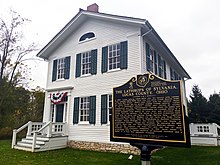
- The Lathrop House, built in 1853 by minister Lucian Lathrop and wife Larissa, was used by abolitionists as a stop on the Underground Railroad. Slaves trying to escape to freedom in the north were given food and shelter, in a secret room behind an oven door.[21][22] The house is recognized by the National Trust for Historic Preservation as a building of significant historical and cultural importance.[23] The building was originally located on Main St, just south of downtown Sylvania, but after a 2002 land dispute, it was moved to Harroun Park across the street.[24]
- The Harroun Family Barn was built by David and Clarissa Harroun in 1858. The Harrouns and their son Edwin aided slaves along the Underground Railroad, transporting them from Maumee, Ohio in David's lumber wagon and hiding them in their basement, before they made their way into Michigan. The Harroun property was connected to the Lathrop house via a ravine that ran between them.[25][26]

- The Sylvania Historical Village is an open-air museum in downtown Sylvania, that features both original and reproductions of historical buildings in the city, including the original railroad depot that operated in the area for over 100 years, and an original 1800s log home.[27][28]

- Fossil Park is a notable attraction that opened in 2001. Visitors can break apart loose shale from a nearby quarry, which often contain fossil specimens such as trilobites.[29] It is one of two locations in the world where visitors without any paleontological experience are allowed to search for fossils themselves.[30]
- The Burnham Building, originally Burnham High School, built in 1927, served as an area high school until the final class graduated in 1960. It was then used as a multipurpose facility until 2010, when it was demolished to make way for the new Maplewood Elementary School.[31][13]
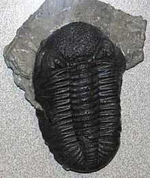 A Phacops rana trilobite fossil found in Fossil Park

Parks and recreation[]
The city is home to over 250 acres of parkland, which include Olander Park, Harroun Community Park, Pacesetter Park, Veterans Memorial Park, and Burnham Park. The Olander Park System ("TOPS") has a large 28 acre pond as well as other satellite parks (Fossil Park, Sylvan Prairie Park, Whetstone Park and Southview Oak Savanna).[32] Pacesetter Park has lacrosse, soccer, and baseball fields, and Burnham Park contains Plummer Pool, a public swimming pool.
Many of Sylvania's recreational activities are organized by the Sylvania Area Joint Recreation Department (SAJRD). They operate multiple facilities and parks, including Pacesetter, Veterans Memorial and Burnham parks, as well as a recreation center, Tam-O-Shanter, with two ice skating rinks and two indoor soccer fields. The center offers indoor sports such as soccer, baseball, lacrosse, ice hockey, and ice skating.[33][34]
The city has received the "Tree City" designation from the Tree City USA program for over 30 years, which recognizes communities for urban and community forestry.[35] The nickname of the city is the literal translation of its name, "City of Trees".[36]
In 2016, a steel beam from the World Trade Center was installed in the "9/11 First Responders Last Call Memorial" at the Toledo Memorial Park cemetery in Sylvania.[37]
Demographics[]
| Historical population | |||
|---|---|---|---|
| Census | Pop. | %± | |
| 1880 | 523 | — | |
| 1890 | 545 | 4.2% | |
| 1900 | 617 | 13.2% | |
| 1910 | 1,002 | 62.4% | |
| 1920 | 1,222 | 22.0% | |
| 1930 | 2,108 | 72.5% | |
| 1940 | 2,199 | 4.3% | |
| 1950 | 2,433 | 10.6% | |
| 1960 | 5,187 | 113.2% | |
| 1970 | 12,031 | 131.9% | |
| 1980 | 15,556 | 29.3% | |
| 1990 | 17,301 | 11.2% | |
| 2000 | 18,670 | 7.9% | |
| 2010 | 18,971 | 1.6% | |
| 2019 (est.) | 19,311 | [5] | 1.8% |
| Sources:[6][38][39][40][41][42] | |||
2010 census[]
As of the census[4] of 2010, there were 18,971 people, 7,642 households, and 5,092 families residing in the city. The population density was 2,926.7 inhabitants per square mile (1,130.0/km2). There were 8,165 housing units at an average density of 1,260.0 per square mile (486.5/km2). The racial makeup of the city was 92.4% White, 2.7% African American, 0.1% Native American, 2.3% Asian, 0.1% Pacific Islander, 0.7% from other races, and 1.7% from two or more races. Hispanic or Latino of any race were 2.9% of the population.
There were 7,642 households, of which 31.3% had children under the age of 18 living with them, 53.0% were married couples living together, 10.1% had a female householder with no husband present, 3.5% had a male householder with no wife present, and 33.4% were non-families. 28.7% of all households were made up of individuals, and 12.8% had someone living alone who was 65 years of age or older. The average household size was 2.43 and the average family size was 3.02.
The median age in the city was 42.7 years. 23.6% of residents were under the age of 18; 7.8% were between the ages of 18 and 24; 21.5% were from 25 to 44; 29.9% were from 45 to 64; and 17.2% were 65 years of age or older. The gender makeup of the city was 47.3% male and 52.7% female.
2000 census[]
| hideLargest ancestries (2000) | Percent |
|---|---|
| German | 32.8% |
| Irish | 15.7% |
| Polish | 10.7% |
| Italian | 6.2% |
| American | 4.9% |
As of the census[6] of 2000, there were 18,670 people, 7,151 households, and 5,070 families residing in the city. The population density was 3,223.2 people per square mile (1,245.0/km2). There were 7,392 housing units at an average density of 1,276.2 per square mile (492.9/km2). The racial makeup of the city was 95.20% White, 1.00% African American, 0.10% Native American, 2.10% Asian, 0.01% Pacific Islander, 0.64% from other races, and 0.96% from two or more races. Hispanic or Latino of any race were 1.63% of the population. The city has a significant Jewish community.
There were 7,151 households, out of which 37.2% had children under the age of 18 living with them, 59.8% were married couples living together, 8.7% had a female householder with no husband present, and 29.1% were non-families. 25.7% of all households were made up of individuals, and 11.2% had someone living alone who was 65 years of age or older. The average household size was 2.59 and the average family size was 3.16.
In the city, the population was spread out, with 28.2% under the age of 18, 6.7% from 18 to 24, 26.7% from 25 to 44, 25.0% from 45 to 64, and 13.3% who were 65 years of age or older. The median age was 38 years. For every 100 females, there were 90.7 males. For every 100 females age 18 and over, there were 86.6 males.
The median income for a household in the city was $57,358, and the median income for a family was $73,947. Males had a median income of $52,892 versus $34,583 for females. The per capita income for the city was $28,163. About 3.7% of families and 4.2% of the population were below the poverty line, including 4.2% of those under age 18 and 3.9% of those age 65 or over.
Government[]
The City of Sylvania follows a mayor–council government.[43] The mayor of Sylvania is Craig Stough.[44] The charter and laws of the City of Sylvania are documented in the Codified Ordinances of the City of Sylvania, Ohio.[45] The judicial branch of the city government is run by the Sylvania Municipal Court,[46] which is presided over by the Honorable Judge Michael A. Bonfiglio.[47]
City Council[]
The city council has seven members, comprising eight committees (Building & Grounds, Employee & Community Relations, Finance, Parks & Forestry, Safety, Streets, Utilities & Environment, and Zoning & Annexation):[48]
- Mark Frye
- Committees: Streets (chairperson), Finance, Safety, Utilities & Environment and Buildings & Grounds
- Patrick Richardson
- Committees: Employee and Community Relations (chairperson), Buildings & Grounds, Finance, Streets and Utilities & Environment
- Katie Cappellini
- Committees: Parks and Forestry (chairperson), Zoning & Annexation, Buildings and Grounds, Employee & Community Relations and Utilities & Environment
- Douglas Haynam
- Committees: Zoning & Annexation (chairperson), Parks & Forestry, Streets, Employee & Community Relations and Finance
- Brian McCann
- Committees: Utilities & Environment (chairperson); Safety; Parks & Forestry; Employee & Community Relations and its Economic Development Sub-committee
- Lyndsey Stough
- Committees: Buildings & Grounds (chairperson), Parks & Forestry, Safety, and Zoning & Annexation
- Mary Westphal (Council President)
- Committees: Finance (chairperson), Safety (chairperson), Zoning and Annexation
Education[]
Sylvania has two public libraries, one near each high school, which are branches of the Toledo-Lucas County Public Library. The Sylvania Branch Library, located near Northview High School, was built in the 1950s, and was expanded and remodeled in 2017.[49] A second library at King Road near Southview High School was built in 2016.[50]
Public[]
Public schools in Sylvania, Ohio are all part of the Sylvania City School District.[51]
- Elementary schools
- Highland Elementary School
- Hill View Elementary School
- Maplewood Elementary School
- Stranahan Elementary School
- Sylvan Elementary School
- Whiteford Elementary School
- Central Trail Elementary School
- Junior high schools
- Arbor Hills Junior High School
- McCord Junior High School
- Timberstone Junior High School
- High schools
- Sylvania Northview High School
- Sylvania Southview High School
Private[]
- Toledo Islamic Academy
- Little Miracles Montessori School
- St. Joseph Elementary & Junior High School
Colleges[]
Sister city[]
Sylvania is the sister city of Woodstock, Ontario, Canada.[52]
Notable people[]
- Sam Abell - photographer
- Mark Berger - economist
- Terry Cook - automobile racing driver
- Alissa Czisny - two-time U.S. champion figure skater
- Chip Davis - musician
- Jon Diebler (born 1988) - basketball player in the Israel Basketball Premier League
- Gordie Howe - hockey player
- Mitchell Miller - hockey player
Notable events[]
- Marathon Classic, an LPGA Tour event that has been played in Sylvania since 1989.
References[]
- ^ "Office Holder Details". Lucas County Board of Elections. 31 December 2015. p. 19. Archived from the original on 16 June 2016. Retrieved 1 February 2016.
- ^ Jump up to: a b "2019 U.S. Gazetteer Files". United States Census Bureau. Retrieved July 28, 2020.
- ^ Jump up to: a b "US Board on Geographic Names". United States Geological Survey. 2007-10-25. Archived from the original on 2012-02-12. Retrieved 2008-01-31.
- ^ Jump up to: a b "U.S. Census website". United States Census Bureau. Retrieved 2013-01-06.
- ^ Jump up to: a b "Population and Housing Unit Estimates". Retrieved May 21, 2020.
- ^ Jump up to: a b c "U.S. Census website". United States Census Bureau. Retrieved 2008-01-31.
- ^ "Total Population: 2010 Census DEC Summary File 1 (P1), Sylvania city, Ohio". data.census.gov. U.S. Census Bureau. Retrieved August 6, 2020.
- ^ Mangus, Michael; Herman, Jennifer L. (2008). Ohio Encyclopedia. North American Book Dist LLC. p. 542. ISBN 978-1-878592-68-2. Archived from the original on 2016-06-18. Retrieved 2016-03-14.
- ^ Scribner, pp. 181
- ^ Cosgrobe, pp. 10-11
- ^ Scribner, pp. 893-894
- ^ Jump up to: a b c Waggoner, Clark (1888). History of the City of Toledo and Lucas County, Ohio. Munsell & Company. p. 892. Archived from the original on 2016-06-17. Retrieved 2016-01-22.
- ^ Jump up to: a b "A Brief History of Sylvania". City of Sylvania. Archived from the original on 2019-04-03. Retrieved 2019-10-27.
- ^ Scribner, p. 185,893
- ^ "Erie & Kalamazoo Rail Road". Ohio History Connection. Archived from the original on 2019-03-14. Retrieved 2019-10-27.
- ^ "Lucas County, 32-48: Erie and Kalamazoo Railroad". Ohio History Connection. Archived from the original on 2017-07-07. Retrieved 2019-10-27.
- ^ "Lucas County". Jim Forte Postal History. Archived from the original on 19 January 2016. Retrieved 21 January 2016.
- ^ Cosgrove, Maynard Giles (1933). A history of Sylvania for the first hundred years [1833-1933];and centennial celebration program. Sylvania, Ohio: Sentinel Publishing Company. pp. 9–10. OCLC 950553827.
- ^ Cosgrove, p. 85
- ^ "Sylvania, Ohio - Trilobites in the Heartland". American Museum of Natural History. Archived from the original on 2019-08-02. Retrieved 2019-10-21.
- ^ "Lathrop House". Heritage Sylvania. Archived from the original on 2019-10-21. Retrieved 2020-04-08.
- ^ "Lathrop House has rich history". The Blade. 2003-10-29. Archived from the original on 2019-10-19. Retrieved 2019-10-21.
- ^ "The Lathrops Family Home". City of Sylvania. Archived from the original on 2019-04-03. Retrieved 2019-10-19.
- ^ Haddad, Keith (2003). Lathrop House Project (PDF). City of Sylvania. Archived (PDF) from the original on 2019-10-19.
- ^ Alkalimat, Abdul; Patterson, Rubin (2017-11-13). Black Toledo: A Documentary History of the African American Experience in Toledo, Ohio. Brill Publishers. pp. 18–19. ISBN 9789004281899.
- ^ "Lucas County, 55-48: The Harroun Family Barn". Ohio History Connection. Archived from the original on 2017-07-07. Retrieved 2019-10-26.
- ^ "About Us". Heritage Sylvania. Archived from the original on 2019-10-21. Retrieved 2019-10-21.
- ^ "Sylvania Historical Village". Toledo.com. Archived from the original on 2019-10-21. Retrieved 2019-10-21.
- ^ Weber, Ann (2008-07-13). "Sylvania's Fossil Park is a fun place to look for the past". The Blade.
- ^ Norfleet, Michele. "The History of Olander Park in Sylvania, Ohio". USA Today. Archived from the original on 2016-05-20. Retrieved 2019-04-03.
- ^ Ryan, Carl (2010-02-21). "Sylvania's Burnham Building begins its tumble". The Blade. Archived from the original on 2019-10-27. Retrieved 2019-10-27.
- ^ Norfleet, Michele. "The History of Olander Park in Sylvania, Ohio". traveltips.usatoday.com. Archived from the original on 2016-05-20. Retrieved 2019-04-03.
- ^ "Recreation - There's Plenty to Do Outdoors". City of Sylvania. Archived from the original on 2017-09-10. Retrieved 2019-04-03.
- ^ "Pacesetter Park". Sylvania Recreation District. Archived from the original on 2018-07-08. Retrieved 2019-04-03.
- ^ "Our Tree Commission". Archived from the original on 2019-10-21. Retrieved 2019-10-21.
- ^ Romaker, Janet (2007-04-18). "Sylvania achieves 'Tree City' milestone Events mark 25th year of winning award". The Blade. Archived from the original on 2019-10-21. Retrieved 2019-10-21.
- ^ "World Trade Center beam installed at Sylvania memorial". Congresswoman Marcy Kaptur. 2016-09-11. Archived from the original on 2019-04-03. Retrieved 2019-04-03.
- ^ "Population of Civil Divisions Less than Counties" (PDF). Statistics of the Population of the United States at the Tenth Census. U.S. Census Bureau. Archived (PDF) from the original on 29 June 2014. Retrieved 28 November 2013.
- ^ "Population: Ohio" (PDF). 1910 U.S. Census. U.S. Census Bureau. Archived (PDF) from the original on 10 November 2013. Retrieved 28 November 2013.
- ^ "Population: Ohio" (PDF). 1930 US Census. U.S. Census Bureau. Archived (PDF) from the original on 9 June 2011. Retrieved 28 November 2013.
- ^ "Report and Tables: New York through South Carolina" (PDF). 1960 Census of Population, Final Population Counts for States. U.S. Census Bureau. p. 69. Retrieved 2 November 2019.
- ^ "Ohio: Population and Housing Unit Counts" (PDF). U.S. Census Bureau. Archived (PDF) from the original on 9 January 2014. Retrieved 22 November 2013.
- ^ "City Offices". City of Sylvania. Archived from the original on 2019-04-03. Retrieved 2019-10-08.
- ^ "Mayor's Office". City of Sylvania. Archived from the original on 2020-10-16. Retrieved 2020-12-12.
- ^ "Codified Ordinances of the City of Sylvania, Ohio". American Legal Publishing Corporation. 2019-01-17. Archived from the original on 2019-07-25. Retrieved 2019-10-08.
- ^ "Our Mission". Sylvania Municipal Court. Archived from the original on 2019-08-05. Retrieved 2019-10-08.
- ^ "Presiding Judge". Sylvania Municipal Court. Archived from the original on 2019-08-05. Retrieved 2019-10-08.
- ^ "City Council". City of Sylvania. Archived from the original on 2020-10-27. Retrieved 2020-12-12.
- ^ Reiter, Mark (2017-07-27). "Library moves ahead with Sylvania branch remodel". The Blade. Archived from the original on 2019-04-29. Retrieved 2019-04-29.
- ^ Guyton, Lisa (2016-09-26). "New multi-million dollar library branch opens in Sylvania". 13ABC.com. Archived from the original on 2016-09-28. Retrieved 2019-04-29.
- ^ "Our District". Sylvania City School District. Archived from the original on 2019-10-18. Retrieved 2019-10-27.
- ^ "Sister City Garden". Sylvania Historical Village. Archived from the original on 4 February 2016. Retrieved 11 April 2015.
Bibliography[]
- Cosgrove, Maynard Giles (1933). A history of Sylvania for the first hundred years [1833-1933];and centennial celebration program. Sylvania, Ohio: Sentinel Publishing Company. OCLC 950553827.
- Scribner, Harvey (1910). Memoirs of Lucas County and the City of Toledo: From the Earliest Historical Times Down to the Present, Including a Genealogical and Biographical Record of Representative Families. 1. Madison, Wisconsin: Western Historical Association. OCLC 213099596.
External links[]
| show Municipalities and communities of Lucas County, Ohio, United States |
|---|

| show Authority control |
|---|
- Cities in Lucas County, Ohio
- Populated places established in 1833
- 1833 establishments in Ohio
- Cities in Ohio