Tehran Province
Tehran Province
استان تهران | |
|---|---|
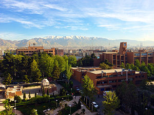
    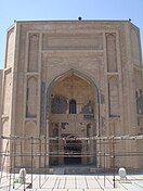  From top left: Azadi Tower, Rudbar-e Qasran Road, Former building of Parliament of Iran, Tangeh Vashi, Tehran skyline view from top of Milad Tower, Jameh Mosque in Varamin, and Tughrul Tower in Rey | |
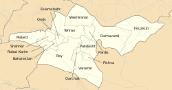 Counties of Tehran Province | |
 Location of Tehran Province in Iran | |
| Coordinates: 35°42′42″N 51°24′25″E / 35.7117°N 51.4070°ECoordinates: 35°42′42″N 51°24′25″E / 35.7117°N 51.4070°E | |
| Country | |
| Region | [1] |
| Capital | Tehran |
| Counties | 16 |
| Government | |
| • Governor | |
| Area | |
| • Total | 18,814 km2 (7,264 sq mi) |
| Population (2016)[3] | |
| • Total | 13,267,637 |
| • Estimate (2020) | 13,973,000[2] |
| • Density | 710/km2 (1,800/sq mi) |
| Time zone | UTC+03:30 (IRST) |
| • Summer (DST) | UTC+04:30 (IRDT) |
| Main language(s) | Persian |
| HDI (2018) | 0.834[4] very high · 1st |

| Year | Pop. | ±% |
|---|---|---|
| 1986 | 8,712,087 | — |
| 2006 | 11,345,375 | +30.2% |
| 2011[5] | 12,183,391 | +7.4% |
| 2016[3] | 13,267,637 | +8.9% |
| amar.org.ir | ||
Tehran Province (Persian: استان تهران Ostān-e Tehrān) is one of the 31 provinces of Iran. It covers an area of 18,814 square kilometres (7,264 sq mi) and is located to the north of the central plateau of Iran.
The province was put as part of the First Region with its secretariat located in its capital city, Tehran, upon the division of the provinces into 5 regions solely for coordination and development purposes on June 22, 2014.[1]
Tehran Province borders Mazandaran Province in the north, Qom Province in the south, Semnan Province in the east, and Alborz Province in the west. The metropolis of Tehran is the capital city of the province and of Iran. As of June 2005, this province includes 13 townships, 43 municipalities, and 1358 villages.
Tehran Province is the richest province of Iran as it contributes approximately 29% of the country's GDP. Furthermore, it houses approximately 18% of the country's population. Tehran Province is the most industrialized province in Iran; 86.5% of its population resides in urban areas and 13.5% of its population resides in rural areas.
The province gained importance when Tehran was claimed the capital by the Qajar dynasty in 1778. Today, Tehran, with a population of 8 million, is ranked amongst the 40 most populous metropolitan cities of the world.

Geography[]
The province of Tehran has over 12 million inhabitants and is Iran's most densely populated region. Approximately 86.5 percent reside in urban areas and 13.5 percent in rural areas of the province.[6]


The largest rivers of this province are Karaj River and Jajrood River.
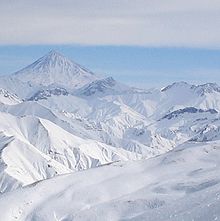
Mountain ranges such as The Alborz span the north; Savad Kooh and Firooz Kooh are located in the north east; Lavasanat, Qarah Daq, Shemiranat, Hassan Abad and Namak Mountains are in the southern areas; Bibi Shahr Banoo and Alqadr are situated in the south east and the heights of Qasr-e-Firoozeh being located to the east of the province.
Environmentally, the climate of Tehran province is stable and has 4 seasons, in winter it's cold and snowy, in spring & autumn it's mild and fresh and rainy, and in summer it's warm to hot and dry. but in the mountains it is cold & and semi-humid all year round, and in the higher regions is cold with long winters. The hottest months of the year are from mid-July to mid-September when temperatures range from 28 °C (82 °F) to 30 °C (86 °F) and the coldest months experience 1 °C (34 °F) around January–February, but at certain times in winter it can reach −20 °C (−4 °F). Tehran city has cold winters and warm to hot summers. Average annual rainfall is approximately 200 millimetres (7.9 in), the maximum being during the winter season mostly in the form of snow. On the whole, the province has a cold semi-arid, steppe climate in the south and an alpine climate in the north.
History[]
Tehran Province has several archeological sites indicating settlements dating back several thousand years. Until 300 years ago, Rey was the most prominent of the cities of the province. However, the city of Tehran rose to become the larger city and capital of Iran by 1778, and since then has been the political, cultural, economic, and commercial nucleus of Iran.
Tehran has over 1,500 historical sites of cultural significance registered with the Cultural Heritage Organization of Iran. The oldest of these in Tehran province are the remains of two sites in Firuzkuh County that date back to the 4th millennium BCE.
Cities[]
The following table shows the ten largest cities of Tehran Province:[7]
| Rank | Name | County | 2016 |
|---|---|---|---|
| 1 | Tehran | Tehran | 8,693,706 |
| 2 | Eslamshahr | Eslamshahr | 448,129 |
| 3 | Shahriar | Shahriar | 309,607 |
| 4 | Qods | Qods | 309,605 |
| 5 | Malard | Malard | 281,027 |
| 6 | Golestan | Baharestan | 239,556 |
| 7 | Pakdasht | Pakdasht | 236,319 |
| 8 | Qarchak | Qarchak | 231,075 |
| 9 | Varamin | Varamin | 225,628 |
| 10 | Nasimshahr | Baharestan | 200,393 |
Divisions[]
Tehran Province is sub-divided into sixteen Counties (shahrestan), listed below with their populations at the 2016 Census:[3]
- Tehran County – 8,737,510
- Damavand County – 125,480
- Ray County – 349,700
- Shemiranat County – 47,279
- Varamin County – 283,742
- Shahriar County – 744,210
- Eslamshahr County – 548,620
- Robat Karim County – 291,516
- Pakdasht County – 350,966
- Firuzkuh County – 33,558
- Qods County – 316,636
- Malard County – 377,292
- Pishva County – 86,601
- Baharestan County – 536,329
- Pardis County - 169,060
- Qarchak County – 269,138
Tehran province today[]
Tehran is the commercial heart of Iran. Tehran province has over 17,000 industrial units employing 390,000 people, 26% of all units in Iran. The province contains 30% of Iran's economy, and comprises 40% of Iran's consumer market. The province has three hydro dams namely Latiyan, Lar, and Amir Kabir as well as two natural lakes, providing the water supply of Tehran and the province.[citation needed]
The province contains 170 mines, over 330 square kilometres of forests, and over 12800 square kilometres of pasture.[citation needed]
Generally speaking, year round, regions such as the southern slopes of the Alborz Mountains, especially in the mountains, valleys, and rivers and artificial lakes formed behind the great dams of Amir Kabir, Latiyan and Lar along with natural lakes of Jaban and Tarr provide considerable recreation for the province.
Moreover, due to excessive snowfall in the northern areas of the province during the winter season, the Alborz mountains form an excellent environment for winter sports such as skiing. Dizin, Shemshak, and Tochal are the most popular skiing resorts.
Transportation[]
Road transport[]

Tehran Province is covered with and connected to other provinces with a big Freeway and Expressway network:

 Freeway 2 (Tehran–Karaj Freeway): This freeway connects Tehran to the capital city of neighboring province of Alborz, Karaj and continues towards Tabriz and Europe.
 Freeway 5 (Tehran–Saveh Freeway): This Freeway connects city of Tehran to its southern suburbs such as Sabashahr, Robat Karim and Parand and continues towards Markazi Province to Saveh and Salafchegan. There are plans to continue the freeway towards Khuzestan.
 Freeway 7 (Tehran–Qom Freeway/Khalij-e-Fars (Persian Gulf) Freeway): This Freeway connects Tehran City to its airport, Imam Khomeini International Airport and continues towards Qom and Isfahan.
- Tehran–Pardis Freeway: This freeway connects Tehran City to its northeastern suburbs such as Pardis, Bumehen and Rudehen and joins Haraz Road and Firuzkuh Road.

 Tehran–Shomal Freeway: This under construction freeway will connect Tehran to Chalus and the touristic areas in Shomal.
 Makhsus Road: This road is the old road from Tehran to Karaj. Because trucks are not allowed on the freeway this road has a high congestion of trucks.
 Road 38: This road connects Tehran to Shahriar and Malard in southwestern Tehran and continues towards Buin-Zahra in Qazvin Province.
 Road 44: This Expressway connects Tehran to Mashhad.
 Road 65 (Saidi Expressway/Saveh Road): This road connects Tehran to its southern suburbs such as Chahardangeh, Eslamshahr and Golestan. It continues towards Saveh and further south towards Isfahan, Abadeh, Shiraz and finally the Persian Gulf coastal industrial city of Asaluyeh.
 Road 71 (Qom old Road): This road is the road that connected Tehran to Qom as a main road before the opening of the freeway in 1980. It is still an important transit road because trucks are not allowed in the freeway.
 (Damavand Road/Haraz Road): This road connects Tehran to cities like Rudehen, Abali and Damavand and continues towards Amol in Mazandaran province in Shomal. It is the most congested road from Tehran to Shomal after Chalous Road.
 Road 79 (Firuzkuh Road): This road connects Tehran to Firuzkuh and Qaemshahr and therefore Sari.
- Greater Tehran Expressway Network:
| show Expressways of Tehran |
|---|

Rail network[]
National Rail Network[]
The city of Tehran is connected to the North, South, West and East with railway. It has weekly trains for Istanbul. Tehran is the headquarters of RAJA (Iran national railway). There maybe plans to build high speed railway lines from Tehran to Mashhad and Isfahan.
Tehran Metro[]

Tehran is served by a system of metro of 3 urban lines (1, 2, 4) and one suburban line (5) serving Karaj and Tehran western suburbs. There are plans to extend the system to 8 urban lines and 4 express suburban lines.
Airports[]
Tehran Province has two main passenger airports:
- Mehrabad Airport
- Imam Khomeini Airport
It also has numbers of air force bases.
Parks, recreation and other attractions[]


- Darband (hiking trail)
- Chitgar Park
- Mellat Park
- Laleh Park
- Jamshidieh Park
- Niavaran Park
- Tangeh Savashi
- Police Park
- Darabad hiking trail
- Darakeh hiking trail
- Jahan-e Kudak Park
- Azadi Sports complex
- Enghelab Sports Complex and Golf course
- Eram Amusement Park
- Several caves, springs, and waterfalls outside Tehran
- Latyan Lake
- Lavizan Forest Park
- Vard-Avard Forest Park
- Khojir National Park
- Kavir National Park
- Tar Lake
- Amir Kabir Lake
- Lar Protected Natural Habitat
- Varjeen Protected Natural Habitat
Religious centers[]
Mosques, shrines, mausoleums, and tombs[]
- Soltani Mosque, built by Fath Ali Shah
- Atiq Mosque, built in 1663.
- Mo'ezz o-dowleh mosque, built by Fath Ali Shah
- Haj Seyd Azizollah mosque, built by Fath Ali Shah
- Al-javad mosque, Iran's first modernist design mosque.
- The Old Sepahsalar mosque, another prominent Qajar era mosque.
- The new Sepahsalar Mosque (Madreseh e Motahari)
- Filsuf o-dowleh Mosque, Qajar era
- Moshir ol-Saltaneh Mosque, Qajar era
- Mo'ayyer ol-Mamalik Mosque, Qajar era
- Shahr Banu Mausopleum
- Javan-mard Qassab Mausoleum, a pre-Islamic semi-mythical hero
- Dozens of Imam-zadeh shrines, hundreds of years old, including that of Imam Zadeh Saleh.
- Dozens of : traditional places of prayer
- Several Tekyehs: traditional places for mourning Muharram ceremonies for Husayn ibn Ali.
- Ebn-e Babooyeh cemetery, where numerous Iranian figures, such as Takhti and Ali Akbar Dehkhoda, are buried.
- Zahir o-dowleh cemetery, housing the tombs of art and cultural figures such as Iraj Mirza, Mohammad Taghi Bahar, Forough Farrokhzad, Abolhasan Saba, Ruhollah Khaleghi, and Darvish-khan are buried.
- Kordan Tomb, Seljuqi era, Karaj.
- Maydanak Tomb, 13th century, Karaj
- The Polish cemetery north of Tehran, where numerous Western Allied soldiers of World War II are buried
Churches[]
- Surep Georg Church, 1790
- Thaddeus Bartoqimus Church, 1808
- Enjili Church, 1867
- Assyrian Church
Colleges and universities[]
Tehran province's major universities are:
- Shariaty Technical College
- Allameh Tabatabaii University
- Amirkabir University of Technology (Tehran Polytechnic)
- Alzahra University
- Shamsipour Technical College
- Baqiyatallah Medical Sciences University
- Farabi Institute of Virtual Higher Education
- Iran University of Science and Technology (IUST)
- Imam Hossein University
- Imam Sadeq University (ISU)
- Iran University of Medical Sciences
- K.N.Toosi University of Technology
- Shahed University
- Shahid Beheshti University
- Sharif University of Technology
- Tarbiat Modarres University (Professor Training University)
- Tehran University of Medical Sciences
- Tarbiat Moaalem University
- University of The Arts
- University of Social Welfare and Rehabilitation Sciences
- University of Tehran
- Islamic Azad University of Tehran-Science and Research
- Islamic Azad University of Pishva
- Islamic Azad University of Islamshahr
- Islamic Azad University of Damavand
- Islamic Azad University of Roodehen
- Islamic Azad University of Tehran-Medical Sciences
- Islamic Azad University North Tehran Branch
- Islamic Azad University of Tehran-South
- Islamic Azad University Central Tehran Branch
- Shahid Beheshti University of Medical Sciences
- Institute for Studies in Theoretical Physics and Mathematics (IPM)
- Hadith College of Tehran
- Imam Ali University for Army Officers
- Comprehensive University of Technology
- Tehran University of Applied Science and Technology
- Bagher Aloloum University
- Iran College of Tele-communications
- Medical University for the Islamic Republic of Iran's Army
- NAJA University of Police
- School of Economic Affairs (SEA)
- School of International Relations
- Shahed University of Medical Sciences
- Shahid Sattari University of Aeronautical Engineering
- University of Islamic Sects
- The Research Institute of The Petroleum Industry
- Iran Polymer and Petrochemical Institute
- Power and Water Institute of Technology(PWIT)
- Payame Noor University
See also[]
References[]
- ^ Jump up to: a b همشهری آنلاین-استانهای کشور به ۵ منطقه تقسیم شدند
- ^ "توجه: تفاوت در سرجمع به دليل گرد شدن ارقام به رقم هزار مي باشد. (in Persian)". Retrieved September 29, 2020.
- ^ Jump up to: a b c "National census 2016". amar.org.ir. Retrieved 2017-03-14.[]
- ^ "Sub-national HDI - Area Database - Global Data Lab". hdi.globaldatalab.org. Retrieved 2018-09-13.
- ^ "National Census 2011" (PDF). amar.org.ir. Retrieved 2020-03-17.[]
- ^ www.sci.org.ir/content/userfiles/_sci_en/sci_en/sel/j-shvro-84.html. Retrieved November 2011[dead link]
- ^ "Tehran (Iran): Counties & Cities - Population Statistics, Charts and Map". www.citypopulation.de. Retrieved 2021-07-17.
External links[]
| Wikimedia Commons has media related to Tehran Province. |
- Official website of Tehran Governorship
- Tehran Province's Cultural Heritage Organization
- . Encyclopædia Britannica (11th ed.). 1911.
| show Places adjacent to Tehran Province |
|---|

| show Authority control |
|---|
- Tehran Province
- Provinces of Iran
- Geography of Tehran